


During the Sanctuary Quest mission, the ROV will be used to “groundtruth” the images that are recorded by the sidescan sonar each evening. Click image for larger view.
Sanctuary Quest
April 24 - June 20, 2002
The U.S. coast from southern California to Washington state features vast areas of submerged mountain ranges, canyons, plateaus, volcanoes, basins, rocky outcrops, and pinnacles, many of which have never been surveyed or explored adequately. These unique conditions contribute to one of the greatest diversities of marine life in the world, including whales, sea otters, seabirds and hundreds of fish species.
Aboard the McArthur, the Sanctuary Quest Expedition team conducted research, exploration, and monitoring within and adjacent to the national marine sanctuaries ![]() in this region. Over the long term, the expedition should help to provide a framework for understanding more about the efficacy and role of the sanctuary system in protecting and conserving marine resources, and to provide the impetus for continued regional research.
in this region. Over the long term, the expedition should help to provide a framework for understanding more about the efficacy and role of the sanctuary system in protecting and conserving marine resources, and to provide the impetus for continued regional research.
Background information for this exploration can be found on the left side of this page. Daily updates are included below. More detailed logs of exploration activities can be found on the right.
![]() Watch an introductory video describing the objectives for the Sanctuary Quest mission. (QuickTime, 2.5 Mb).
Watch an introductory video describing the objectives for the Sanctuary Quest mission. (QuickTime, 2.5 Mb).
Updates & Logs
Click images or links below for detailed mission logs.
June 20 The entire Olympic Coast NMS crew spent a welcome night at home because of the ships' one-day early return. Everyone pitched in today to get the open house ready for the public. Because of security concerns, access to the ship was limited to media, students and VIPs. Over 300 people dropped by City Pier to see the ship, the ROV and a dozen or more exhibits on Olympic Coast NMS research and programs.
Click image for larger view.

June 19 With news of an early end to our mission, Sanctuary Quest researchers relaxed last night, watching videos in the wardroom and preparing for our arrival in Port Angeles. We docked at City Pier and began offloading personal gear and scientific equipment. Once ashore, the action shifted to the Olympic Coast NMS office, where staff are busy preparing for tomorrow's open house.
Read a wrap up of the Olympic Coast Sanctuary Quest leg in their last mission log.


June 18 CO Craig Bailey is still concerned about ROV operations and the ship's unpredictable propulsion. We resumed wildlife transects off Cape Flattery and encountered a vast feeding flock of shearwaters and other birds. Among the birds, two groups of between four and six humpbacks were lunge-feeding. We captured hydroacoustic data showing a large mass of zooplankton and fish near the surface.
Bad news comes at mid-day: because of the McArthur's mechanical problems, the mission will end a day early and no paleoshoreline dives will be attempted.
Click images for larger view.

June 17 Today we were hampered by high seas and rough weather, effectively curtailing all of our operations. Archaeologist Gary Wessen came aboard to begin our paleoshoreline dives. We've made a weather retreat into the lee of Cape Flattery. Tonight, propulsion problems with McArthur forced cancellation of one benthic habitat and one paleoshoreline dive.
Click image for larger view.

June 16 The wildlife survey began near Cape Flattery and we followed a line 45 miles to the west. Today, we saw 46 individual humpbacks, bringing the mission total to 121 individuals. All day we were accompanied by black-footed albatross.
The night operations began over the head of Nitinat Canyon, almost 40 miles from Cape Flattery. Our first dive began well with a brief look at the canyon edge. Ship and ROV soon drifted out into the canyon and we lost view of bottom. Our first dive had to be aborted once we had lowered all but 10 meters of tether. In other words, we ran out of rope. Our second dive proved very productive up on the plateau at the canyon's edge. We were surrounded all night by giant Pacific halibut, spot prawns and squid. The dive was disappointing from a habitat standpoint—most of the bottom appeared to have considerable trawl track damage. The most dramatic scene we encountered involved a halibut butting the ROV.
Follow the ROV day and night explorations in today's mission log.

June 15 Today's wildlife surveys were spectacular, including a sighting of a black tern, usually associated with inland marsh habitats, not 17 miles offshore. Bird numbers, particularly sooty shearwaters, are unexpectedly low. We saw 50 Pacific white-sided porpoise, a minke whale, eight orca whales, eight humpback whales and two northern fur seals. We enjoyed the evening just south of Tatoosh Island lighthouse with a barbeque and birthday party for the ship's June birthdays, Chief Marine Engineer Paul Lovejoy and Ordinary Seaman Chip Stephens on McArthur's fantail. The crew broke out their Hawaiian shirts for the occasion. Our night dive was on the edge of the Juan de Fuca Canyon and was cut short due to difficulty locating and holding station on the site. In the wee hours, we dove at another location on the canyon edge. One surprise was a view of the bottom covered with brittle stars.
Read more about today's work in the full mission log.

June 14 We started early this morning with wildlife surveys in exceptionally clear weather and flat seas. Another great day for humpbacks—37 whales in 16 groups. Behaviors included lots of fluking and several displays of full breaching. Birds were abundant, including Cassin's auklets, Leach's storm petrels, ancient murrelets and on South polar skua—a long way from its breeding grounds in Antarctica.
Dive operations have shifted to an area about 19 miles off Point of Arches, on the southwest wall of the Juan de Fuca Canyon. Here we might find, according to historic trawl data, ancient coral and sponge habitat.
Want to get close enough to smell a humpback's breath? Then join the crew as they follow these amazing creatures in today's mission log.


June 13 Today, we were able to start the wildlife surveys early in beautiful conditions. Humpback whales were abundant and we were able to lower one of the ship's launches to approach whales for photo identification. As the boat went from whale to whale, up to 3 miles from the ship, the seabird and whale sighting effort continued on the flying bridge. In all, we sighted 14 groups of whales, totaling 24 individuals. We encountered on lone Northern fur seal. That evening, we returned to The Rockpile and launched the ROV at about 8 pm. Organisms we observed included hagfish, hydrocorals, rockfish, hydroids, skates, and flatfishes. Once again, thruster problems halted ROV operations.
Click images for larger view.

June 12 We launched the ROV at about 8:30 a.m., diving in an area about 17 miles off the mouth of the Quillayute River. At about 50 meters we began seeing large boulders covered with plumose sea anemones and large schools of rockfish. The dive ended at about 10:30 a.m. The light fog lifted, allowing us to begin an east-west wildlife survey transect. We saw six humpback whales and had a very productive day of birding. Species we saw included blackfooted albatross, sooty shearwaters, Cassin's auklets and others. Conditions were beautiful. In the afternoon, we had fire and abandon ship drills. In the evening, we returned to The Rockpile to continue ROV operations. Our evening dive was aborted because of thruster problems on the ROV.
Click image for larger view.

June 11 The Olympic Coast Sanctuary Quest mission is underway. The McArthur departed Aberdeen at about 6:30 p.m. and crossed the Grays Harbor bar into the Pacific. Our first mission dive was planned near Point Grenville to investigate reported methane seeps. High seas forced us to cancel the dive. We continued steaming north to our second set of dives, on a feature off La Push we call The Rockpile and arrived on station in the early hours of the morning.
Click image for larger view.

June 5 The Cordell Bank leg of the Sanctuary Quest mission wraps up. Read Michael Carver's, a biological technician for the Cordell Bank National Marine Sanctuary, description of how the ROV was used during their exploration of this dramatic undersea environment.
Click here for the mission log.
![]() Watch a short video taken from the ROV while exploring Cordell Bank. (QuickTime, 980k).
Watch a short video taken from the ROV while exploring Cordell Bank. (QuickTime, 980k).

June 3 The team attempted to leave Drake's Bay, but swells up to twelve feet turned them back. The scientists had time to calibrate the echosounder, an instrument that gives a visual display of the biomass in the water column. Sea-surface and salinity readings are being recorded constantly while in transit. This is interesting to watch because it is upwelling season, and there are fronts of very cold water mixed in between warmer fronts of water. When we were outside San Francisco, the salinity reading was much lower than at other areas because of the outgoing fresh water tidal plume coming out of San Francisco Bay.
Click image for larger view.


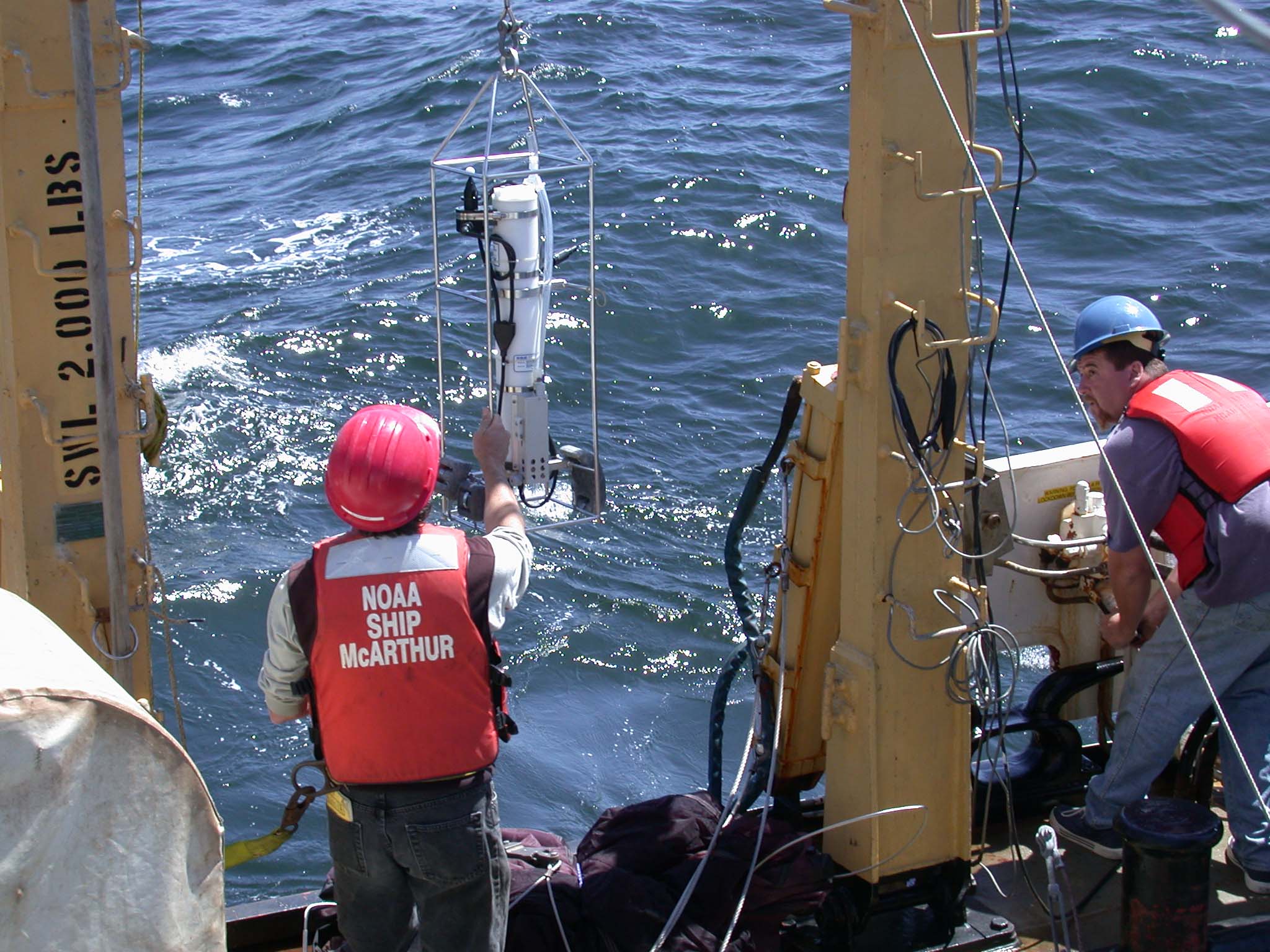
June 2 Despite high winds and swells, a lot of work was accomplished in the Gulf of the Farallones National Marine Sanctuary. Four seabird/marine mammal surveys were done. A “hotspot” of activity was located west of San Francisco, where the outgoing tidal plume (bright green and turbid colored water) met with the offshore (dark green, blue colored water). Brandt's cormorants, Western gulls, Common Murres, and a Tufted Puffin (all nesting species on the Farallon Islands) were spotted. It is nesting season, and these adults were probably foraging to feed their young. As we headed offshore, just past the continental shelf break, a pod of Dall's porpoise was spotted. In between surveys, four CTD's (conductivity, temperature, depth) were done at established Ecosystem Dynamics Study (EDS) stations.
Click images for larger view.
![]() Watch a short video on the Cordell Bank monitoring efforts. (QuickTime, 1.1 Mb).
Watch a short video on the Cordell Bank monitoring efforts. (QuickTime, 1.1 Mb).

June 1 Ten to fifteen foot swells and 20-30 knot winds keep us anchored in Drakes Bay. If the weather does make a significant switch, we are close enough to motor out and get some work done.
Click image for larger view.
![]() Watch a short video showing the rough seas. (QuickTime, 1.0 Mb)
Watch a short video showing the rough seas. (QuickTime, 1.0 Mb)

May 26 - 27 The Cordell Bank National Marine Sanctuary leg of the Sanctuary Quest Mission gets underway. Within the first two days they've spotted schools of blue, yellowtail, and widow rockfish, scattered lingcod, and a six-gill shark.
Read more about all the creatures discovered in the full mission log.

May 31 Although the weather still didn't look good, the McArthur headed out of San Francisco. A short wildlife survey was accomplished; lots of Common Murres were seen. These birds tend to concentrate on the continental shelf waters this time of year.
We also were able to get a water profile of conductivity, temperature, at depth (CTD) reading as well as a cholorphyll profile. The swells were pretty rough, so we turned around and anchored in Drakes Bay around Point Reyes to avoid the rough seas. When the swells are large we can't deploy the ROV because the boat has to maintain position while the ROV is motoring around. If the boat starts moving, the ROV starts to get dragged along with it, which is unsafe for the equipment. The conditions also make it difficult and unsafe to deploy the tucker trawl and manta nets.
Click image for larger view.
May 30 ROV repairs went well, all systems were checked and ready to go. The weather offshore didn't look too good, so the McArthur stayed in port another night.


May 29 Four Ecosystem Dynamics Study stations were monitored between 10 p.m. and 4:30 a.m. The surface manta tows pulled in the regular gelatinous zooplankton, phytoplankton and a variety of juvenile fishes, such as rockfish, lingcod, and lantern fish (a fish that produces bioluminescent light).
As the night crew signed off for the night (or is it morning?) the daytime ROV and wildlife observers hit the deck ready to go. Sometime during the ROV dive, there was a technical difficulty that required the McArthur to head back to San Francisco for repairs. The team expects to be up and running again tomorrow.
Click images for larger view.


May 28 Another great day of calm weather. This morning on a seabird and marine mammal survey; Alcids, Black-footed Albatross, Sooty Shearwater, Rhinocerous Auklet, Dall's Porpoise, Pacific White Sided Dolphin, and Risso's Dolphin were all seen. Lots of blue sharks appeared in convergence zones (areas where different water masses converge).
ROV surveys covered the base of the bank around 300 feet, up to shallower pinnacle habitats. Footage has revealed 3 different types of algae, lots of echinoderms, anemones, sponge, rockfish, lingcod, and another six-gill shark.
Click images for larger view.
![]() Watch a short video demonstrating an ecosystem dynamic study process. (QuickTime, 896k).
Watch a short video demonstrating an ecosystem dynamic study process. (QuickTime, 896k).

May 25 After four days in the Gulf of the Farallones the McArthur finished this leg of the Sanctuary Quest research cruise. The science team was able to gather valuable information to add to the long-term Ecosystem Dynamics Study.
Read a wrap up of this leg of the mission in the full mission log.

May 23 Completed night sampling at three stations with the Tucker trawl, a multi net one-meter plankton net that allows stratified sampling of the water column. The surface layer of the ocean is sampled with a Manta net that skims along the top of the water. The Tucker nets were filled with copepods, krill and several species of juvenile fishes. The manta nets are picking up good numbers of juvenile rockfish, krill and juvenile Dungeness crab.
The ocean is cold and very productive. In the morning, three humpback whales are observed feeding near the NOAA ship McArthur. Feeding flocks of shearwaters and auklets continue to work the surface and Common Murres (Uria aalge) are common. The salmon fleet out of San Francisco has also been around us the entire cruise. The Gulf of the Farallones is alive.
Click images for larger view.

May 22 A seabird and marine mammal observation transect was conducted. Wildlife observers see aggregations of seabirds on the ocean, surface feeding shearwaters and lots of Cassin's Auklets (Ptychoramphus aleuticus) and Common Murres (Uria aalge). The latter two species are foraging in the food rich waters to feed their young who are on the nearby Farallon Islands.
Learn more about the wildlife observation study in the full mission log.

May 21 On Tuesday morning, the first day in the Gulf of the Farallones, five humpback whales (Megaptera novaeangliae) are sighted as the NOAA ship McArthur heads toward the Farallon Islands. The first activity for the daytime science team was to deploy the ROV just north of Southeast Farallon Island. As the ROV dives under the water a curious California sea lion (Zalophus californianus) is seen in the forward looking camera swimming by to seemingly check out the strange object entering its world. The ROV encounters difficulty diving deeper, so the decision is made to head into the calmer waters of Drake's Bay near Point Reyes to make adjustments.
Click image for larger view.

May 20 The McArthur headed back out to sea at 9 p.m. after spending several days preparing the ROV and acoustics equipment. After passing under the Golden Gate Bridge the ship went straight to the first of three areas to measure ocean conditions and sample zooplankton. This sampling is part of long-term Ecosystem Dynamics Study correlating plankton abundance and marine wildlife sightings. The science team plans to have research operations 24 hours a day with plankton sampling at night. During the day the other part of the science team will be sampling for chlorophyll at the same areas and making observations for marine mammals and seabirds while in transit between sampling stations. The main component of the daytime operations will be to use the ROV to do habitat characterization of the ocean bottom by giving the science team real time video of marine life and seafloor.
Click image for larger view.

May 1 On Wednesday, the NOAA ship McArthur experienced a fire in one of their main generators while docked in Port Hueneme. The ship had come into port because of strong winds and high seas that had curtailed all operations. Staff from the NOAA Office of Marine and Aviation Operations are currently working to repair the damage, and it is anticipated that the ship will depart for San Francisco on approximately May 15 to prepare for work in the Gulf of the Farallones National Marine Sanctuary. Operations in the Monterey Bay sanctuary have been cancelled.
![]() ROV Operator Vince Gerwe describes the advantages of an ROV in a short video clip. (QuickTime, 920k).
ROV Operator Vince Gerwe describes the advantages of an ROV in a short video clip. (QuickTime, 920k).
Read about ROV operations in the full mission log.

April 30 Early Tuesday morning, the NOAA Ship McArthur transited east from Santa Rosa Island after the completion of sidescan sonar operations. At 10:30 am, the McArthur arrived at Yellow Bluffs on the south side of Santa Cruz Island. The ROV was deployed for 1.5 hours in 250 feet of water. Scientists recorded live notations onto the digital video images captured by the ROV. This system enables the scientists to verify the initial identification of all fish and invertebrate species, and determine the characteristics of the area's habitat. At this particular dive site, the habitat primarily included sandy bottom and some rocky outrcroppings.
Biologists identified Pacific and speckled sandabs, blacksmith, blackeyed goby, and several species of rockfish. They also identified invertebrates like white sea urchins, a fish-eating sea star, red sea stars, sea pens, and pelagic red crabs. Pelagic red crabs have been seen around the Channel Islands in recent weeks as well, which may indicate the start of an El Niño event.
Click image for larger view.

April 29 The ROV sustained moderate damage when it was accidentally sucked into the McArthur's prop. Expedition team members replaced its umbilical cord. The ROV's manipulator arm also was damaged, one of its lights was broken, and its frame was bent during the accident. Additional sidescan sonar operations were conducted in place of ROV operations.
Click image for larger view.

April 28 Great sea conditions and visibility today! The Expedition team encountered Risso's Dolphins (Grampus griseus) in groups of three, purple-striped jellyfish (Pelagia colorada), California sea lions (Zalophus californianus), By-the-Wind Sailors (Velella velella) and ocean sunfish (Mola mola). Sidescan sonar operations were conducted off the coast of San Miguel Island.
Click image for larger view.

April 27 The Sanctuary Quest team headed out for a successful first couple of days. Traveling to the south side of Santa Cruz Island, the conditions were perfect for SCUBA and remotely-operated vehicle (ROV) operations in Smugglers Cove.
Learn more about the first several mission days in the full mission log.

April 22-25 Docked in San Diego, the NOAA ship McArthur was loaded with the research equipment needed for the two-month-long expedition, including an ROV, winch, A-frame, operation van, sidescan sonar, and much more. The crew then spent the rest of the time hooking up the sidescan sonar equipment and testing the ROV equipment, all in preparation for the launch. The photography crew set up, used time-lapse techniques to film the mobilization efforts, and collected video imagery of the ship.
![]() Watch a video on one of the goals of the mission. (QuickTime, 1.1 Mb)
Watch a video on one of the goals of the mission. (QuickTime, 1.1 Mb)
Sign up for the Ocean Explorer E-mail Update List.