


Mapping the Puerto Rico Trench Explorers
Leg I: September 24-30, 2002 Leg II: February 18-March 7, 2003
William Danforth
Amy Kennedy
Rebecca Lester
Catalina Martinez
Gene Parker
Taconya Piper
Chris Polloni
Rex Roettger
Uri ten Brink
Toshi Uozumi
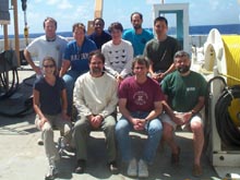
Science crew on Leg II of the Puerto Rico Trench mapping expedition. Click image for larger view.
 William Danforth
Geologist
U.S. Geological Survey
Woods Hole, MA
William Danforth is a geologist who has worked with the USGS Woods Hole Field Center ![]() for 15 years. He serves as a sea floor mapping specialist and helps lead the development, implementation, and maintenance of digital techniques for the collection, processing, analysis, and display of acoustic/imaging data. His 12 years of field experience includes participating in numerous cruises throughout the U.S. Exclusive Economic Zone, collecting side-scan sonar, seismic, bathymetric, and multibeam data for the U.S. Geological Survey, as well as collaborative efforts with universities, other government agencies and private firms.
for 15 years. He serves as a sea floor mapping specialist and helps lead the development, implementation, and maintenance of digital techniques for the collection, processing, analysis, and display of acoustic/imaging data. His 12 years of field experience includes participating in numerous cruises throughout the U.S. Exclusive Economic Zone, collecting side-scan sonar, seismic, bathymetric, and multibeam data for the U.S. Geological Survey, as well as collaborative efforts with universities, other government agencies and private firms.
 Amy Kennedy
Marine Mammal Observer
Amy Kennedy graduated from the Maine Maritime Academy with a degree in ocean science. She then joined the crew of the NOAA Ship Whiting as a hydrographic survey technician. After a year and a half of charting, she accepted a position as senior survey technician aboard the NOAA Ship Miller Freeman. Currently, Ms. Kennedy is a contract marine mammal observer with extensive experience in aerial and shipboard marine mammal data collection and photography. Her work has taken her to Alaska to study large whales and harbor porpoise, British Columbia to study gray whales, Florida to study right whales and manatees, and the west coast to study the distribution of killer whales.
 Rebecca Lester
Marine Mammal Observer
Center for Coastal Studies
Rebecca Lester is an intern at the Center for Coastal Studies in Provincetown, MA. She works with the Humpback Whale Studies Program, focusing primarily on population monitoring. She is also undertaking an analysis of the effect of research vessels on cow-calf pairs, and is involved in public education as an assistant naturalist on whale-watching vessels. Ms. Lester graduated from the University of Melbourne in 2000 with bachelor's degrees in environmental engineering and zoology. She spent several months with Massachusetts Bays/Coastal Zone Management assisting their aquatic entomologist and their volunteer coordinator on the Wetland Health Assessment Toolbox program.
 Catalina Martinez
Web Coordinator
NOAA Office of Ocean Exploration
Catalina Martinez joined NOAA's Office of Ocean Exploration (OE) as a Dean John A. Knauss Marine Policy Sea Grant Fellow in 2002 from the University of Rhode Island (URI). She completed a master's degree in oceanography from URI in 2000, and received another master's in marine affairs from URI in 2002. She developed and implemented education programs as an outreach educator in marine science through URI's Office of Marine Programs, as well as through the National Science Foundation's K-12 Graduate Teaching Fellowship program. She has worked on fishery and other marine related issues in various regions of the world. Her most recent work with OE took her on research cruises to the Gulf of Alaska and the northwestern Hawaiian Islands.
 Gene Parker
Hydrographic Surveyor
NOAA Ocean Service
Gene Parker has 15 years experience with NOAA's National Ocean Service (NOS) nautical charting program as a hydrographic surveyor, conducting single beam echosounder, multibeam, and side-scan sonar surveys. His education includes oceanographic and marine technology studies at the Florida Institute of Technology. His current NOAA position encompasses a wide range of duties, including training hydrographic field personnel and conducting cartographic reviews, data verification, and quality assessment of NOAA and contract surveys. Gene is also a certified NOAA diver. As a team member of the PROBE Expedition II, his responsibilities included acquisition, processing, and graphical presentation of bathymetric data.
 Taconya Piper
John A. Knauss Marine Policy Fellow
NOAA
Office of Ocean Exploration
Taconya Piper joined NOAA's Office of Ocean Exploration (OE) this year as a Dean John A. Knauss Marine Policy Fellow from the University of Maryland's Sea Grant College. She has a B.S. in Environmental Science from the University of Maryland Eastern Shore, and a M.S. in marine-estuarine environmental science with a specialization in fisheries science also from the University of Maryland Eastern Shore. As a graduate student, she participated in the Student Career Experience Program working with NOAA's Northeast Fisheries Science Center. She was also the recipient of an Environmental Protection Agency's Graduate Research Fellowship.
 Chris Polloni
Research Technologist
U.S. Geological Survey
Woods Hole Field Center
Chris Polloni is a computer specialist with over 30 years experience in oceanographic data acquisition, processing, displaying and archiving. As a research technologist for the Sea floor Mapping Group at the USGS Woods Hole Field Center ![]() , he helps coordinate GIS applications and research methods for data processing, visualization and publication. In Project PROBE, he assisted with data processing and archiving of the SeaBeam multibeam data stream. His work on board the NOAA Ship Ronald H. Brown, utilizing the SeaBeam system, has revealed new geologic features in and around the Puerto Rico Trench. He helped map the same area with the Geologic Long Range Inclined Asdic (GLORIA, an early deep-ocean marine side scan system) in 1986.
, he helps coordinate GIS applications and research methods for data processing, visualization and publication. In Project PROBE, he assisted with data processing and archiving of the SeaBeam multibeam data stream. His work on board the NOAA Ship Ronald H. Brown, utilizing the SeaBeam system, has revealed new geologic features in and around the Puerto Rico Trench. He helped map the same area with the Geologic Long Range Inclined Asdic (GLORIA, an early deep-ocean marine side scan system) in 1986.
 Rex Roettger
Educator-at-Sea
Ramey School
Puerto Rico
Rex Roettger joined project PROBE as part of the educational outreach effort. His responsibilities included collecting images to document the scientific research, serving as a watch standard, and sharing his experience with students back in the classroom. He has 15 years of teaching experience; presently, he teaches science at the middle and high school levels at Ramey School in Puerto Rico. Mr. Roettger has a B.S. in education with an emphasis in biological science from Ohio University, and is now finishing a master's in educational technology from Humboldt State University. Currently, he is collaborating with Penn State University on a research project studying hydrothermal vent and cold seep communities.
 Uri ten Brink
Research Geologist
U. S. Geological Survey
Woods Hole Field Center
Uri ten Brink is a Research Geologist with the U.S. Geological Survey's Woods Hole Field Center ![]() in Woods Hole, MA. A native of Israel, Uri ten Brink grew up spending much of his free time hiking and sailing. After military service and an undergraduate degree in geology and physics, he moved to New York, where he obtained his Ph.D. in marine geophysics from Lamont-Doherty Earth Observatory of Columbia University. His Ph.D. thesis, and later work, explored the relationship between volcanic eruptions, volcano spacing, and the stresses created by the weight of volcanoes in the Hawaiian chain. During his post-doctoral work at Stanford University, and later as a scientist at the USGS Woods Hole Field Center, he co-led three over-snow seismic traverses in Antarctica, and initiated scientific cooperation between Israeli, Jordanian, and Palestinian scientists in studying the Dead Sea and the Dead Sea rift. Presently, much of his research is focused on understanding the processes that formed the Puerto Rico Trench, and on the development of real-time moored ocean bottom seismometers. Uri ten Brink is also an adjunct scientist at the Woods Hole Oceanographic Institution
in Woods Hole, MA. A native of Israel, Uri ten Brink grew up spending much of his free time hiking and sailing. After military service and an undergraduate degree in geology and physics, he moved to New York, where he obtained his Ph.D. in marine geophysics from Lamont-Doherty Earth Observatory of Columbia University. His Ph.D. thesis, and later work, explored the relationship between volcanic eruptions, volcano spacing, and the stresses created by the weight of volcanoes in the Hawaiian chain. During his post-doctoral work at Stanford University, and later as a scientist at the USGS Woods Hole Field Center, he co-led three over-snow seismic traverses in Antarctica, and initiated scientific cooperation between Israeli, Jordanian, and Palestinian scientists in studying the Dead Sea and the Dead Sea rift. Presently, much of his research is focused on understanding the processes that formed the Puerto Rico Trench, and on the development of real-time moored ocean bottom seismometers. Uri ten Brink is also an adjunct scientist at the Woods Hole Oceanographic Institution ![]() .
.
 Toshi Uozumi
Physical scientist
Atlantic Hydrographic Branch
Norfolk, VA
Toshi Uozumi is a physical scientist at the Atlantic Hydrographic Branch in Norfolk, VA. He became involved in hydrography after graduating from the University of Southern Mississippi with a master's degree in marine chemistry. Mr. Uozumi began his hydrographic survey experience aboard the NOAA Ship Rainier as an assistant survey technician.