

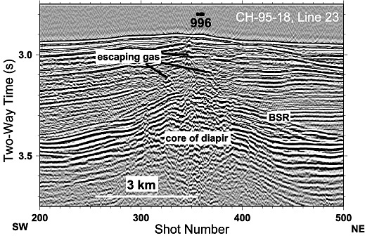
Single channel seismic data (line 23 of R/V Cape Hatteras cruise 95-18) collected by the US Geological Survey crossing the Blake Ridge Diapir from southwest (left) to northeast (right) provides an image of the subseafloor. The diapir is the pronounced concave feature in the middle of the diagram. The feature labelled BSR is a bottom-simulating reflector that marks the base of the gas hydrate zone. Gas hydrate (“methane ice”) is stable in the overlying sediments, but only methane gas can exist in the sediments beneath the BSR. The BSR is clearly visible on the diapir's flanks, but it is warped upward and disrupted over the center of the diapir. Vertically oriented features above the center of the diapir are faults that provide conduits for methane and other chemicals to reach the sea floor, where they can be used to sustain chemosynthetic communities.
Related Links
Windows to the Deep Exploration