In January 2021, President Joe Biden signed an Executive Order that puts America on the path to protect 30% of its land and 30% of its ocean areas by 2030 to fight climate change and restore balance to the ecosystems that we depend on for clean air and water, food, and quality of life.
June is a month to celebrate the ocean. On June 8, people around the globe will celebrate World Ocean Day with the theme of “one ocean, one climate, one future – together.” President Biden has declared June to be National Ocean Month, recognizing in his proclamation that ocean exploration and research will help us gain new insights into ocean ecosystems and biodiversity and the ocean’s role in climate moderation. And June marks the launch of the 10-year United Nations Decade of Ocean Science for Sustainable Development , a global cooperative program to deliver the science we need for the ocean we want, to achieve a healthy, safe, and resilient ocean for sustainable development by 2030 and beyond.
Since its inception in 2001, NOAA Ocean Exploration has been involved in collecting data and information that have been used in decisions to protect some of our nation’s most important marine places. As we move forward to the next 20 years, we will continue to contribute foundational data needed to understand, and therefore protect, our ocean.
This June, as we celebrate our ocean and 20 years of NOAA Ocean Exploration, here’s a look at some of the marine protected areas where our data has made a difference.
Protecting an Underwater Mountain: Expansion of Monterey Bay National Marine Sanctuary
In 2008, the boundary of Monterey Bay National Marine Sanctuary was expanded to protect Davidson Seamount, one of a group of submarine volcanoes off the continental margin offshore central California. Expeditions supported by NOAA Ocean Exploration in 2002 and 2006 revealed that this massive underwater structure hosts large coral forests, vast sponge fields, crabs, deep-sea fish, shrimp, basket stars, and high numbers of rare and unidentified species, helping to illustrate the need to protect Davidson Seamount.
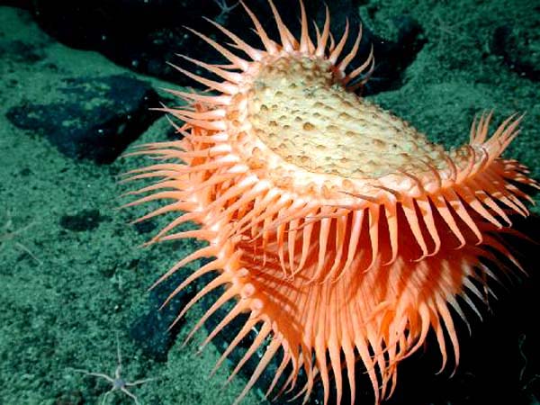
Found at 1,875 meters (6,150 feet) depth on the slopes of Davidson Seamount during the 2006 Davidson Seamount: Exploring Ancient Coral Gardens expedition, this unidentified anemone resembles a Venus flytrap. Image courtesy of NOAA/MBARI.
Learn moreEnTRENCHed in Data: Marianas Trench Marine National Monument Established
A series of “Ring of Fire” expeditions in 2003, 2004, and 2006 supported by NOAA Ocean Exploration led to discoveries that played a significant role in the designation of the Marianas Trench Marine National Monument in 2009. The monument was established to protect features such as submerged volcanoes, hydrothermal vents, coral reef ecosystems, and biologically diverse ecosystems. Subsequent NOAA Ocean Exploration expeditions to the region, including the 2016 Deepwater Exploration of the Marianas, have provided insights to the geology and biology within this national monument.
During the 2016 Deepwater Exploration of the Marianas, the team observed active venting and thick volcanic smoke at Daikoku Seamount, within the Marianas Trench Marine National Monument. These observations supported the hypothesis that this underwater volcano had erupted as recently as 2014. Video courtesy of NOAA Ocean Exploration, 2016 Deepwater Exploration of the Marianas.
Learn moreFirst of Its Kind: Northeast Canyons and Seamounts Marine National Monument Established
In 2016, President Barack Obama established the Northeast Canyons and Seamounts Marine National Monument to protect fragile and largely pristine deep-sea environments. Located about 130 miles off the coast of Cape Cod, Massachusetts, it is the first and only marine national monument in the Atlantic Ocean. Data and information collected during mapping and remotely operated vehicle expeditions led by NOAA Ocean Exploration in 2013 and 2014 were instrumental in establishment of the monument. These expeditions provided some of the first visual surveys of the canyons and seamounts now protected within monument boundaries and confirmed the existence of deep-sea coral and sponge habitats, deepwater fish habitats, and other vulnerable marine habitats that warrant protection. A NOAA Ocean Exploration expedition in 2019 provided additional insights to help in the management of the monument.
Retriever Seamount, which is one of four seamounts within the boundary of the Northeast Canyons and Seamounts Marine National Monument, is home to a diverse array of marine life, such as those within this sponge community discovered during a 2019 NOAA Ocean Exploration dive. Video courtesy of NOAA Ocean Exploration, Deep Connections 2019.
Learn moreOne of the Biggest Gets Bigger: Expansion of Papahānaumokuākea Marine National Monument
Papahānaumokuākea Marine National Monument protects over 1,508,870 square kilometers (582,578 square miles) of the Pacific Ocean, making it one of the largest marine protected areas in the world. Established in 2006, the monument was expanded in 2016, in part due to data collected during NOAA Ocean Exploration expeditions in 2015 and 2016. During these expeditions, we conducted some of the first visual surveys of monument waters at depths greater than 2,000 meters (6,560 feet), collecting critical baseline information to meet NOAA science and management needs within the Hawaiian Archipelago.
In 2016, NOAA Ocean Exploration conducted a dive at depths between 1,600 to 1,800 meters (5,250 to 5,905 feet) on an unnamed seamount within Papahānaumokuākea Marine National Monument. Located east of Bank 9, this seamount had never been surveyed. Video courtesy of NOAA Ocean Exploration, Hohonu Moana 2016.
Learn moreReducing Impacts: Frank R. Lautenberg Deep-Sea Coral Protection Area Created
Data and information collected during seafloor mapping and visual surveys on NOAA Ocean Exploration-led expeditions in 2012, 2013, and 2014 informed the establishment of the Frank R. Lautenberg Deep-Sea Coral Protection Area, which protects more than 100,000 square kilometers (38,610 square miles) of seafloor habitat in the Mid-Atlantic region. Created by the Mid-Atlantic Fishery Management Council in 2016, this large marine protected area protects deep-sea corals from the impacts of bottom-tending fishing gear.
During the Windows to the Deep 2019 expedition, while exploring Baltimore Canyon off the coast of Virginia, we encountered these large, healthy walls of Paragorgia, or bubblegum coral. These corals have been around a very long time, serving as important habitat for other animals. They are now protected within the Frank R. Lautenberg Deep-Sea Coral Protection Area. Video courtesy of NOAA Ocean Exploration, Windows to the Deep 2019.
Learn more