


Expedition Purpose
Why Are Scientists Exploring Midwater Communities of the Celebes Sea?
A key purpose of NOAA’s Ocean Exploration Initiative is to investigate the more than 95 percent of Earth’s underwater world that until now has remained virtually unknown and unseen. Such exploration may reveal clues to the origin of life on Earth, cures for human diseases, answers on how to achieve sustainable use of resources, links to our maritime history, and information to help protect endangered species. Indonesia is well-known as one of Earth’s major centers of biodiversity. Although Indonesia covers only 1.3 percent of Earth’s land surface, it includes:
• 10 percent of the world’s flowering plant species;
• 12 percent of the world’s mammal species;
• 16 percent of all reptile and amphibian species; and
• 17 percent of the world’s bird species.
In addition, together with the Philippines and Great Barrier Reef, this region has more species of fishes, corals, mollusks, and crustaceans than any other location on Earth.
What, exactly, is meant by biodiversity, and why is it important? The term ‘biodiversity’ is usually understood to include variety at several levels:
• variety of ecosystems: high biodiversity suggests many different ecosystems in a given area;
• variety of species: high biodiversity suggests many different species in a given area;
• variety of interactions between species; and
• variety within species (genetic diversity); high biodiversity suggests a relatively high level of genetic variety among individuals of the same species.
A simple definition of biodiversity could be: ‘The variety of all forms of life, from genes to species, to the broad scale of ecosystems.’
Biodiversity is important to humans because our survival depends upon many other species and ecosystems. Some examples are:
• fresh air containing oxygen;
• clean water;
• productive soils;
• food, medicines and natural products;
• natural resources that provide the basis for human economies; and
• natural beauty that improves our quality of life.
(adapted from the Biodiversity Project, http://www.biodiversityproject.org/bdimportant.htm ![]() ).
).
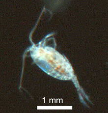
Quite a lot is known about Indonesia’s terrestrial and shallow-water ecosystems. But scientific knowledge and understanding of mid-water ocean communities is generally sketchy, and many mid-water animals have not been studied at all - even though the midwater ocean environment (everything between the sea surface and the ocean floor) is our planet’s largest ecosystem. Midwater animals range from microscopic zooplankton to the largest animals on Earth, provide a major source of nutrition for benthic (bottom) communities, and are an important link in the transfer of energy and materials from the top to the bottom of the ocean.
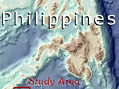
The seas of Indonesia and the Philippines (including the Sulu, Banda, Celebes, Java, Molucca, and Halmahera Seas) are the only deep-water gap between the continental shelves of Australia and Southeast Asia. Water flowing from the Western Pacific Ocean into the Indian Ocean is channeled by numerous island chains to form a series of ocean currents known as the Indonesian Throughflow. The dominant Throughflow current passes off the southern Philippines into the Celebes Sea (which is partially enclosed by Borneo (Kalimantan) and the island of Celebes (Sulawesi), then flows through the Makassar Strait, around Java and the Lesser Sunda Islands, and eventually becomes part of the west-flowing South Equatorial Current.
The path of the Indonesian Throughflow through the Celebes Sea coincides with an imaginary boundary known as ‘Wallace’s Line.’ Alfred Russell Wallace was an English naturalist who spent eight years in Indonesia during the mid-1800’s studying wildlife and collecting specimens for museums. During his travels, Wallace noticed that animals on the island of Bali seemed to be related to similar species found in Asia, while animals on the Island of Lombok (only 20 miles away to the southeast) were very different and more closely resembled species in Australia. The boundary between these two ‘zoogeographic regions’ became known as ‘Wallace’s Line,’ and extends from the middle of the Celebes Sea, through the Makassar Strait between Borneo and Celebes, through the strait between Bali and Lombok.
Wallace and Darwin
By 1858, Wallace had written "On the Tendency of Varieties to Depart Indefinitely From the Original Type," in which he outlined the idea of the origin of species by natural selection. Wallace sent his paper to Charles Darwin for comment, unaware that Darwin had independently formulated a very similar theory. Eventually, Wallace and Darwin made a joint public announcement of their ideas, but since Wallace was thousands of miles away in Indonesia, Darwin became much more widely associated with the concepts of natural selection and evolution.
This junction of two great zoogeographic regions is sometimes referred to as ‘Wallacea,’ and is an area of particularly high biological diversity and endemism. Endemic species are species that are found nowhere else. The high number of endemic species in Wallacea is probably due to several factors:
• High temperatures associated with the tropical climate are thought to increase rates of mutation, which in turn increase the opportunity for new species to arise;
• The presence of many islands creates habitats that are more or less isolated from each other, and such isolation favors the evolution of new species that are uniquely adapted to local conditions; and
• During past ice-ages, lower sea levels created land bridges between the islands of Java, Borneo, Sumatra and Bali and allowed species to spread among these islands, but deep ocean trenches prevented migrations to islands to the east.
These factors help explain the diversity of terrestrial organisms on either side of Wallace’s Line; but what about marine organisms? Does Wallace’s Line also exist in the ocean environment? Recent research on the genetics of some marine species suggests that populations in the seas of Indonesia may also be biologically isolated from each other, even though strong currents would be expected to spread larvae around the region and prevent this kind of isolation.
Why is this important? Because Earth’s marine habitats are in serious trouble. In particular, coral reefs are in decline: 10% of reef environments have already been permanently lost, and this figure may increase to as much as 70% by the year 2020 (Wilkinson, 1992). Protected areas known as marine reserves are one way to deal with this problem; studies have shown that marine reserves can help restore biomass and diversity in over-exploited communities. To be effective, though, marine reserves must have a supply of new organisms to re-populate such communities, and for many marine species this means a supply of larval organisms.
So, decisions about the size and location of marine reserves require information on how much interaction or ‘connectivity’ exists between populations in a given region. One way to predict connectivity is to examine the currents that flow between populations, and couple these data with information about the larval cycle of organisms of interest (organisms with long larval cycles would be expected to travel farther than those with shorter cycles). But this approach may not give an accurate picture if there are other factors that tend to keep populations isolated from each other.
Because so little is known about organisms in Indonesian midwater communities, there are probably many other ways in which these organisms are important. For example, salps are transparent planktonic animals belonging to the subphylum Tunicata (also known as Urochordata). They are chordate animals like humans and other vertebrates, but look more like jellyfish. Salps are found throughout Earth’s oceans, but are rarely seen because their jelly-like bodies are easily damaged by nets. Even so, they can multiply into dense swarms containing billions of individual animals. Each animal consumes microscopic plants (phytoplankton), and a large swarm may remove as much as 74% of the phytoplankton present in surface waters in a single day. Carbon compounds contained in the phytoplankton are eventually excreted in the salps’ fecal pellets, which sink rapidly to the bottom of the ocean. In this way, scientists estimate that a swarm of salps may transport up to 4,000 tons of carbon into deep water each day. Because the carbon in phytoplankton is derived from atmospheric carbon dioxide, carbon transport by salps may have a significant impact on removing this greenhouse gas from the atmospheric circulation.
The 2007: Exploring the Inner Space of the Celebes Sea Expedition is focused on exploring the variety of midwater organisms in the most biologically diverse region on Earth. Key expedition questions include:
• What animals are found in Indonesian midwater communities?
• How does the biodiversity of Indonesian midwater communities compare with other marine communities in this region, and with other midwater communities in other regions?
• What proportion of animal species in Indonesian midwater communities is endemic to this region (found nowhere else on Earth), and how does this degree of endemism compare with that of other regions?
Expedition scientists will use a variety of tools and techniques to answer these questions. A specially-designed trawl net will be used to collect physical specimens from midwater communities. Oceanographic conditions such as conductivity, temperature, depth, and dissolved oxygen will be measured with instruments attached to the trawl. Additional specimens will be collected using a remotely operated robotic vehicle (ROV), as well as by divers using specialized blue-water diving techniques. Underwater digital video cameras will provide the first-ever video images of living animals in the deep basins of the Celebes Sea. Additional information on Expedition technology is provided below.
Exploration Technology
CTD - A CTD collects data on seawater conductivity, temperature, and depth. These data can be used to determine salinity of the seawater which is a key indicator of different water masses. For more information about CTDs, visit http://www.oceanexplorer.noaa.gov/technology/tools/sonde_ctd/sondectd.html ![]() .
.
MOCNESS Trawl - MOCNESS stands for Multiple Opening and Closing Net, with an Environmental Sensing System. ‘Multiple’ means that MOCNESS can include from six to 20 nets supported on a sturdy rectangular frame that is towed by a research vessel at a speed of two to three knots. Sensors attached to the frame report conductivity (salinity), temperature, depth, and chlorophyll, oxygen and light levels. MOCNESS nets are made of fine mesh ranging in size from 64 microns up to 3 mm, and can sample as deep as 6,000 meters. For more information on MOCNESS, visit http://www.whoi.edu/instruments/viewInstrument.do?id=10008 ![]() .
.
Blue-water Diving - Traditionally, midwater animals are collected in nets pulled behind research vessels or indirectly as stomach contents of other animals captured with nets, fishing lines, or traps. Recently, submersibles have also been used to sample midwater populations. These techniques usually damage at least some of the collected species, particularly gelatinous zooplankton. An alternative approach is to make collections with divers using ordinary SCUBA equipment. Diving in the open ocean is quite different from nearshore diving, because there are no objects for visual reference, and it is very easy for divers to become disoriented. Techniques for blue-water diving have been developed by scientists participating in the 2007: Exploring the Inner Space of the Celebes Sea Expedition that use a system of lines and floats to create visual reference points and a means for keeping divers in touch with each other. For more information, see the essay on blue-water diving at http://oceanexplorer.noaa.gov/explorations/07philippines/background/diving/diving.html
Ropecams - Ropecams are underwater digital video cameras equipped with waterproof lights and attached to a rope. Usually, several cameras are attached to a single line and lowered into the water column. Timers turn the lights and cameras on and off at fixed time intervals to obtained video imagery of animals in the vicinity of the ropecams. Often bait is used to attract animals into range of the cameras. Ropecams provide a quick and relatively inexpensive way to obtain video images in deep-sea environments. For more information on ropecams, see the essay on Expedition Technologies at http://oceanexplorer.noaa.gov/explorations/07philippines/background/tech/tech.html and http://www.kodak.com/US/en/corp/features/digitalInnovators/kristof/index.shtml ![]()
Global Explorer ROV - The Global Explorer Remotely Operated Vehicle is an underwater robot built and operated by Deep Sea Systems International. The ROV can be equipped with high resolution digital and high definition television imaging equipment, as well as a variety of tools for geological and biological sampling. The vehicle is rated for a maximum depth of 10,000 feet, and may be towed by a support vessel or operated in a free-swimming mode powered by six thrusters controlled via a tether connected to the support ship. For more information on the Global Explorer ROV, visit http://www.oceanexplorer.noaa.gov/explorations/02arctic/logs/sep5/media/rov.html and http://www.globalexplorerrov.com/about.htm ![]() .
.
For More Information
Contact Paula Keener-Chavis,
Director, Education Programs
NOAA Office of Ocean Exploration
Other lesson plans developed for this Web site are available in the Education Section.