
By Dr. Martha Nizinski, NOAA Office of Science and Technology, National Systematics Laboratory
August 24 - September 9, 2016

NOAA Ship Pisces underway. Image courtesy of the NOAA. Download larger version (jpg, 509 KB).
Submarine canyons continue to be areas of high interest to federal and state agencies tasked with research and management responsibilities, particularly those for deep-sea corals. Most canyons are poorly known, but based on data retrieved from previous investigations, many scientists and managers believe submarine canyons provide refuge for a variety of fauna including corals, fishes, and other animals.
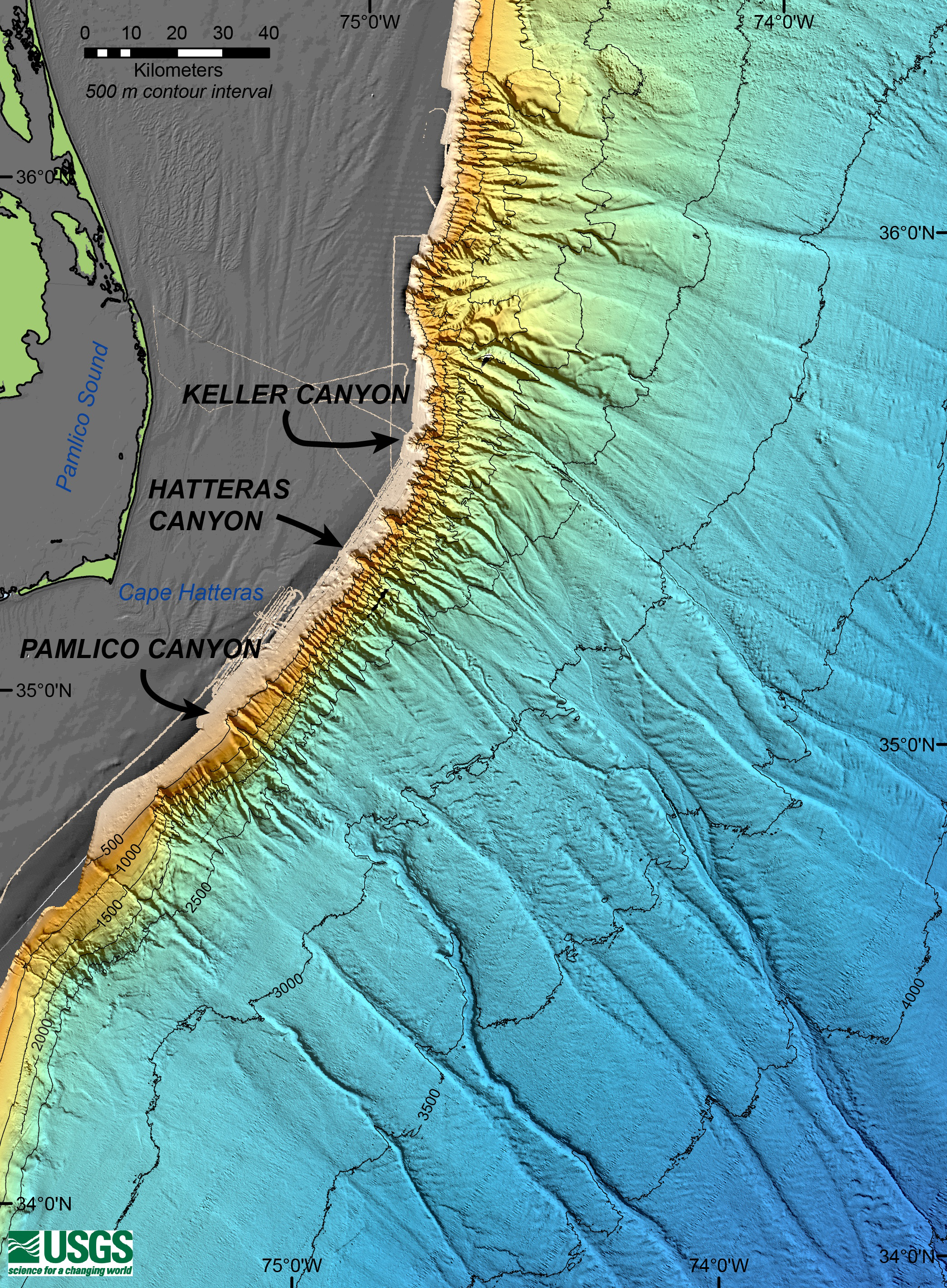
Beginning on August 24, 2016, a team of scientists and engineers aboard NOAA Ship Pisces will spend 15 days at sea exploring three deepwater canyons off the coast of North Carolina. Specifically, the team will target Keller, Pamlico, and Hatteras canyons.
 off the coast of North Carolina will be surveyed for deep-sea coral habitats.")
This map displays the operating area of the Exploring Carolina Canyons expedition. Three submarine canyons (Keller, Hatteras, Pamlico) off the coast of North Carolina will be surveyed for deep-sea coral habitats. Image courtesy of Walter Cho, Woods Hole Oceanographic Institution. Download larger version (jpg, 5.6 MB).
With the overall goal of surveying suspected deep-sea coral habitats associated with these canyons, the team will conduct a science mission with the following objectives:
Autonomous underwater vehicle, Sentry. Image courtesy of Walter Cho, Woods Hole Oceanographic Institution. Download larger version (jpg, 185 KB).
Using the autonomous underwater vehicle (AUV) Sentry as the primary sampling gear, the team will spend approximately three days in each canyon. The objective of the first AUV deployment in each canyon will be to collect multibeam bathymetry data. During an eight- to twelve-hour deployment, Sentry will conduct reconnaissance to provide images of the bottom terrain. Using these data, the team will then plan a much longer deployment, at least 40 hours in duration, to collect images of the seafloor. These imagery deployments will cover those areas where deep-sea coral habitats are most likely to occur.
Depending on the multibeam results, the mission will then focus on either discrete areas of interest, such as mounds or other areas of high relief, or follow long transects along depth contours in areas of high slope (> 30°) gradients within the canyons. Sentry will not only be taking high-quality images of the biology and geology of the canyon, but will also be monitoring a variety of environmental parameters (i.e., depth, salinity, turbidity, and dissolved oxygen).
When Sentry is on board the ship to download data and recharge batteries, the team will conduct a variety of other ship-based operations to study these submarine canyons. First, a CTD rosette will be deployed to aid in the characterization of the water column down the axis of the canyon. This apparatus records the depth, salinity, and temperature profile of the water column and collects water samples at depth. These water samples will be analyzed to characterize the stable carbon and nitrogen composition of the particulate organic matter (i.e., food) at targeted depths. Additionally, the team will attach a monocore to the CTD on several of these deployments. The monocore will take a discrete sample of the bottom sediments. These samples will be used to characterize the infaunal community structure and composition, including abundance and diversity of these organisms, and their associated environment (e.g., chlorophyll a, organic carbon, and particle size).
Throughout the mission, the ship’s multibeam system will map the seafloor in regions where data are missing or incomplete. By filling in these “holes,” the team aims to complete a high-quality image of the seafloor topography. These maps will be important for mission planning, not only for this cruise, but also for future missions in the region.


