
By Alanna Durkin, Temple University
Most expeditions rely on remotely operated vehicles (ROVs) for exploration and sample collection. These robotic submersibles are tethered to the ship so pilots can control the ROV’s position and sampling, and scientists can see the view from the sub’s cameras in real time. An autonomous underwater vehicle (AUV), on the other hand, goes on untethered, solo missions with a set course and only reveals its findings after being retrieved and brought back on board.
So what does it look like when a deep-sea cruise’s primary sampling equipment is an AUV? Although AUVs don’t collect samples to bring to the surface like ROVs, by using the AUV Sentry, the DEEP SEARCH expedition team will still collect valuable ecological data by giving scientists a “birds-eye view” of some known sites and some completely unexplored habitats.
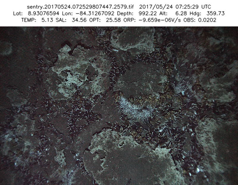
AUV Sentry took this image of chemosynthetic mussel beds at Mound 12 on the Costa Rica margin on an R/V Atlantis research cruise in May 2017. Image courtesy of WHOI from a cruise with the AUV Sentry under the direction of Dr. Erik Cordes, Temple University. Download larger version (jpg, 450 KB).
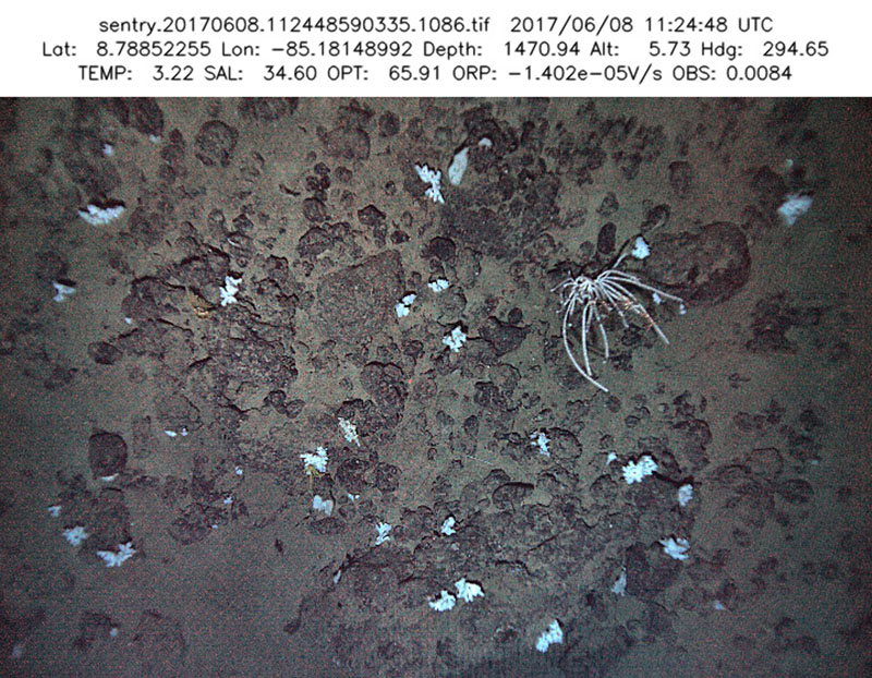
These sponges and coral were seen on the same R/V Atlantis cruise to the Costa Rica margin on a seamount. Image courtesy of WHOI from a cruise with the AUV Sentry under the direction of Dr. Erik Cordes, Temple University. Download larger version (jpg, 513 KB).
The AUV being used in this cruise, Woods Hole Oceanographic Institution’s Sentry , is equipped with a multibeam echosounder to map seafloor bathymetry, a suite of sensors to measure water chemistry, and a downward-looking camera to image benthic habitats and communities. When combined, these data create a comprehensive picture of a patch of seafloor, telling scientists more about what the habitat looks like, what animals live there, and what kind of physical environment the animals are living in. The high-resolution photos are taken in a regular, overlapping pattern to make photomosaicking possible and create one continuous image of the dive area.
How does this snapshot fulfill the goals of the DEEP SEARCH project? Sentry’s data perform three major functions:
In addition to expanding our knowledge of previously visited sites along the continental margin, many of Sentry’s dives will target new, unexplored sites that have been selected because they are likely to have habitats of interest. Finding new canyons to explore is relatively easy with access to bathymetry data from previous Mid-Atlantic cruises, and many likely cold seep sites have been identified from sonar data that detects bubble plumes in the water column.1
Sentry will be deployed to map the expected seafloor source of these bubbles to confirm that methane is being released from an active seep and investigate the ecological community this seep supports. Additionally, the AUV will be equipped with special sensors for measuring fluorescence and oxidation-reduction potential (ORP), both indicators of seepage in the water column, to help us determine the levels and quality of seep activity required for the chemosynthetic community to thrive.
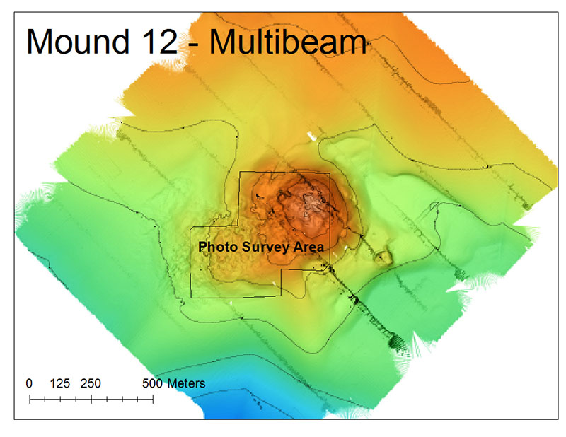
AUV Sentry first collects multibeam data to map the bathymetry of the seafloor, which helps scientists find features of interest such as the large mound seen here. Map created by Alanna Durkin. Download larger version (jpg, 451 KB).
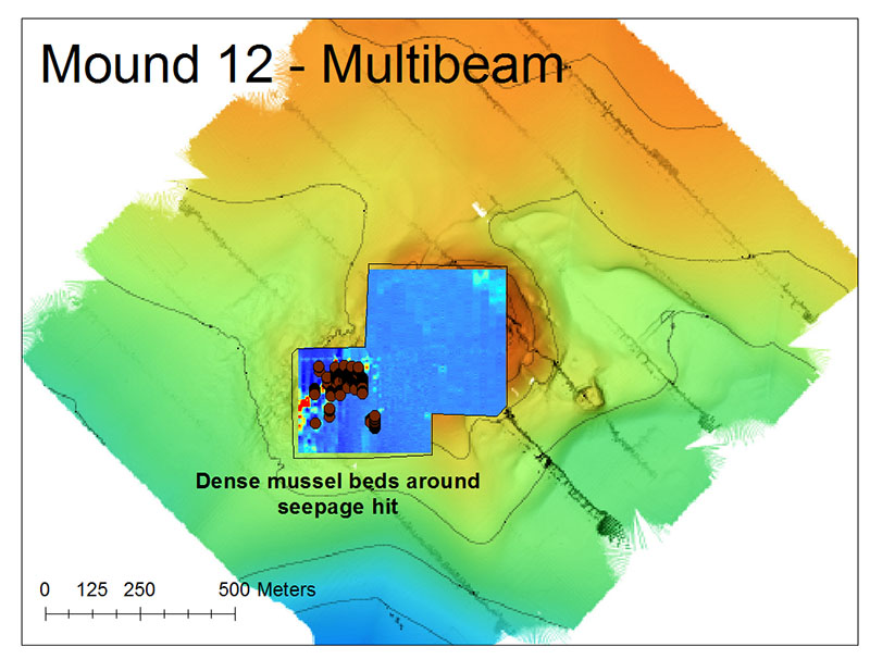
This high-resolution bathymetric map of a mussel bed was created using AUV Sentry data. The red dots designate dense clusters of mussels found at a seep. Map created by Alanna Durkin. Download larger version (jpg, 477 KB).
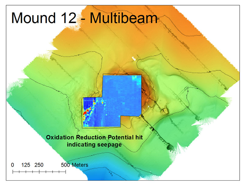
Data collected from the oxidation-reduction probe (ORP sensor) illustrates reducing environments (red) located around the mussel bed. These areas often correspond to low oxygen conditions around active seepage. Data collected from these sensors, combined with the high-resolution maps (see above) and imagery, help us understand the spatial extent of seep communities and their associated environmental conditions. Map created by Alanna Durkin. Download larger version (jpg, 483 KB).
Finding new, unknown cold-water coral habitats is the most challenging task when choosing dive targets. Given the importance of deep-sea coral reefs for supporting diverse fish populations and the vulnerability of corals to human impacts, researchers have risen to this challenge by designing predictive distribution models for many different coral species.2 Through years of observation and experiments, scientists have determined the habitat features and environmental conditions that these corals prefer and best tolerate and used the data to build these models.
Sentry will dive on several sites that have been deemed most likely to support coral populations to either confirm or refute the model’s predictions. Regardless of whether the AUV is successful in finding a deep coral reef, its sensors will be measuring temperature, salinity, pH, and dissolved oxygen to feed these models new oceanographic data, improve their predictive capabilities, and inform hypotheses about limitations to coral dispersal along the Mid-Atlantic continental margin.
The maps and photomosaics gathered from Sentry on this cruise are only the first step in this multi-cruise project. Future expeditions will take seafloor samples using ROVs and deploy and monitor moorings and benthic landers. The AUV-collected data will help us make informed decisions about which sites need to be explored further or which communities are the best to sample from. Sentry is serving as our “eyes” this fall so that future robot arms don’t sample blindly, making future explorations more efficient and fruitful!
1 Skarke A, Ruppel C, Kodis M, Brothers D, Lobecker E. Widespread methane leakage from the sea floor on the northern US Atlantic margin. Nat Geosci. 2014;7(9):657-661. doi:10.1038/Ngeo2232.
2 Georgian SE, Shedd W, Cordes EE. (2014) High resolution ecological niche modelling of the cold-water coral Lophelia pertusa in the Gulf of Mexico. Mar Ecol Prog Ser 506: 145-161. doi: 10.3354/meps10816