Seamounts Named to Honor NOAA and Partners’ Role in Ocean Exploration
August 13, 2020
Three seamounts in the Pacific Ocean now bear names honoring the contributions to science made by NOAA and its partners in ocean exploration during a campaign led by the NOAA Office of Ocean Exploration and Research (OER). Seamounts are just what their name implies, mountains in the sea. Usually of volcanic origin, they are defined as seafloor features that are at least, and often more than, 1,000 meters (3,300 feet) tall.

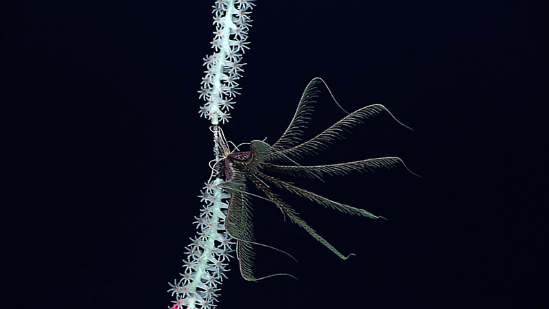
This feather star (unstalked crinoid) was seen attached to a coral during a March 11, 2016, dive on what has since been named Okeanos Explorer Seamount. Seamounts are oases of life. With structure for animals to settle and live on and currents supplying food and nutrients, seamount biodiversity (variety of life) is often high. Image courtesy of the NOAA Office of Ocean Exploration and Research, 2016 Hohonu Moana. Download larger version (778 KB).
Two of these seamounts are located south of Midway Islands within the Papahānaumokuākea Marine National Monument, which protects the Northwestern Hawaiian Islands.
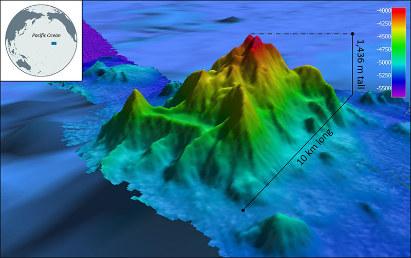
The Okeanos Explorer Seamount was named to honor NOAA Ship Okeanos Explorer for the role it played in the seamount's discovery. OER scientists first mapped the 1,436-meter (4,711-foot) feature using shipboard mapping sonars and then explored it with OER’s remotely operated vehicle (ROV) Deep Discoverer during the 2016 Hohonu Moana expedition. This expedition also marked the deepest exploration in the monument (to date) and provided resource managers with critical data about unexplored parts of the monument. The Okeanos Explorer Seamount will be an enduring reminder of the important work conducted aboard the ship, the only federal vessel dedicated to exploring our largely unknown ocean for the purpose of discovery and the advancement of knowledge about the deep ocean, in one of the largest conservation areas on Earth.

This image shows the topography of the Okeanos Explorer Seamount. The seamount was named after NOAA Ship Okeanos Explorer, which played a key role in its discovery in 2016. Colors represent water depth in meters as defined in the color key. Image courtesy of the NOAA Office of Ocean Exploration and Research, 2016 Hohonu Moana. Download larger version (629 KB).
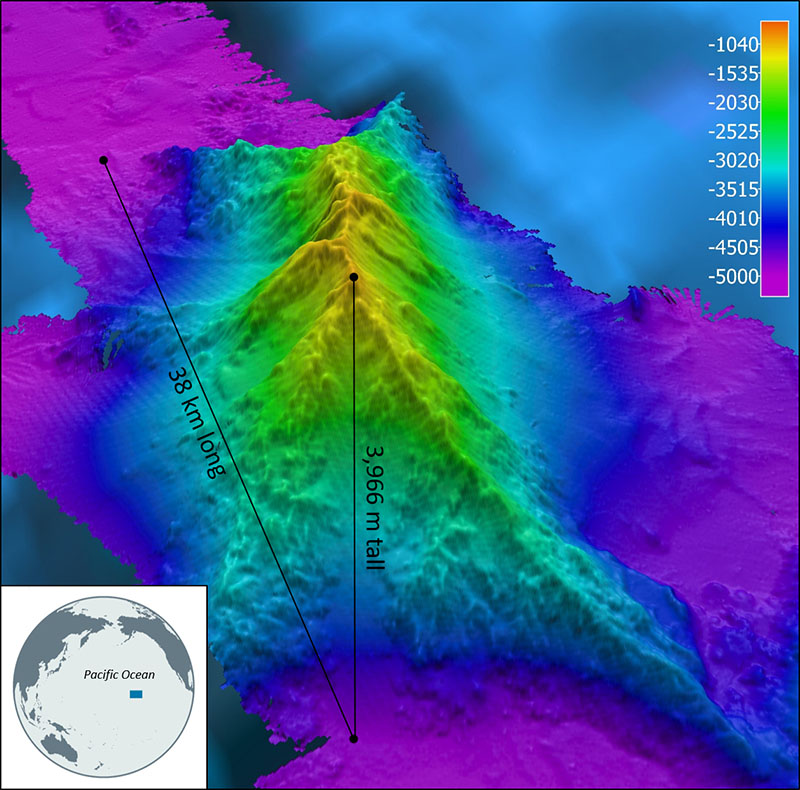
Named for the Hawaiian word for “discovered,” the Kaunana Seamount, at 3,966 meters (13,012 feet), is the tallest of the three seamounts introduced here. It honors OER’s ROV Deep Discoverer for its role in the discoveries made in the region. During the campaign, Deep Discoverer conducted the deepest exploration of the monument to date, and data collected with the vehicle have greatly contributed to our understanding of the monument’s deep-sea habitats.

This image shows the topography of the Kaunana Seamount. The seamount was named in honor of OER’s remotely operated vehicle Deep Discoverer for its role in the discoveries made during an expedition to the Northwestern Hawaiian Islands. Colors represent water depth in meters as defined in the color key. Image courtesy of the NOAA Office of Ocean Exploration and Research, 2016 Hohonu Moana. Download larger version (804 KB).
Further to the west, between the Northern Mariana island of Anatahan and the Mariana Trough, lies the 2,352-meter (7,717-foot) Afa’maolek Seamount. In the language of the CHamoru people indigenous to Guam and the Northern Mariana Islands, “Afa’maolek” translates to “to be good to one another, collaborate, form a group, help out, cooperate with, be friends.” The name was chosen to honor both the collaborative work conducted aboard Schmidt Ocean Institute’s Research Vessel Falkor and Okeanos Explorer during operations in the Mariana region as well as the local indigenous language and culture.
These aren’t the first seamounts named to recognize NOAA’s work. In fact, the first deep-sea feature to be formally categorized as a seamount was named after geographer George Davidson from the U.S. Coast and Geodetic Survey, one of NOAA's predecessor agencies. The 2,400-meter (7,874-foot) Davidson Seamount, now part of the Monterey Bay National Marine Sanctuary, was discovered during the mapping of California's coast in 1933 and visited during a number of OER-supported expeditions in the last two decades.
With much of our ocean still unmapped and unexplored, there are many seamounts, and other features, still to be discovered — and named. Anyone can propose a name: Staff from NOAA’s Office of National Marine Sanctuaries at the monument proposed the names for the Okeanos Explorer and Kaunana seamounts, and Schmidt Ocean Institute proposed the name for the Afa’maokek Seamount. However, it’s up to the interagency U.S. Board on Geographic Names (BGN) to approve these names.
Congress has authorized the BGN to standardize and approve geographic names for use throughout the federal government. The BGN’s Advisory Committee on Undersea Features provides the board with advice on matters related to undersea features beyond the seaward boundaries of territorial seas, recommending standardization policies and name approvals to ensure the consistency of geographic names on maps and charts and related publications. Currently, the BGN has approved names for approximately 5,000 undersea features.
As demonstrated here, NOAA plays an important role in ocean exploration. Future efforts by NOAA and partners to improve our understanding of the ocean and the resources within it have been bolstered by, and will support, the recent Presidential Memorandum on Ocean Mapping in the U.S. Exclusive Economic Zone and Shoreline and Near Shore of Alaska and National Strategy for Mapping, Exploring, and Characterizing the United States Exclusive Economic Zone. In addition, they will support international initiatives, such as the Department of Defense’s Indo-Pacific Strategy and Seabed 2030 , which is a collaborative effort that aims to produce the definitive map of the world ocean floor by 2030, and provide important opportunities to engage other countries as partners in ocean exploration.