NOAA Ocean Exploration Awards $4 Million to Advance Ocean Knowledge
Through the Ocean Exploration Fiscal Year 2022 (FY22) Funding Opportunity, NOAA Ocean Exploration selected eight projects for financial support totaling approximately $4 million. For the FY22 competition, we solicited proposals for projects to conduct or support ocean exploration resulting in outcomes that provide or enable initial assessments about unknown or poorly understood regions of U.S. waters. The funding opportunity invited proposals for projects under the themes of ocean exploration, marine archaeology, or technology that align with the outcomes of the Workshop to Identify National Ocean Exploration Priorities in the Pacific and support the National Strategy for Mapping, Exploring, and Characterizing the United States Exclusive Economic Zone (pdf).
AUV-Based Acoustic Mapping and Characterization of Seafloor Hydrothermal Discharge
Principal Investigator: Guangyu Xu, University of Washington
Hydrothermal vents often feature a variety of unique biological communities and metal-rich deposits, making them important to society and economies. However, most hydrothermal vent sites discovered to date are on the deep-ocean floor at great depths below the sea surface. Because of the inherent difficulties of deep-sea exploration and the inadequacy of existing vent-characterization techniques, the majority of the known hydrothermal vent fields remain poorly studied, and many sites are yet to be discovered. To advance our knowledge about hydrothermal vents, this research team will develop an innovative approach to identifying, locating, and characterizing hydrothermal discharge using an autonomous underwater vehicle (AUV) equipped with coordinated multibeam sonars. After a robust evaluation program, which will include computer simulations and laboratory experiments at an engineering tank facility, the new approach will be demonstrated at an active hydrothermal vent site off the Oregon/Washington coast. Anticipated outputs include seafloor bathymetry, 3D acoustic plume images, quantitative vent maps, and 3D panoramic images of vent sites. By extending the capabilities of AUVs, this project will deliver an efficient approach to collecting comprehensive baseline data about hydrothermal activity needed by researchers and policy makers.
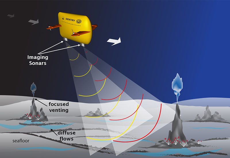
This schematic illustrates how the project team will use an autonomous underwater vehicle to collect seafloor data using coordinated multibeam sonars. Image courtesy of Kim Reading, Applied Physics Lab, University of Washington. Download largest version (jpg, 364 KB).
Characterizing Variability in Pacific Northwest Methane Seeps Using a Fleet of Small AUVs
Principal Investigator: Craig McNeil, University of Washington
Methane is a potent greenhouse gas, and it’s released into the ocean from the seafloor as gas bubbles via methane seeps. Despite the prevalence of seeps along continental margins, data is limited, and their impacts on the ocean and atmosphere, both positive and negative, are poorly understood. To advance our knowledge about methane seeps, this research team will develop and demonstrate an approach to efficiently and effectively map and characterize methane seeps over wide areas. This approach will use easily deployable and relatively inexpensive autonomous underwater vehicles equipped with imaging sonars and custom sensors to find and map seeps and measure associated bubbles and dissolved methane right at the source and up through the water column. The team will demonstrate their approach at known seep sites off the coasts of Washington and Oregon with the goal of improving our understanding of how methane from these seeps influences life on the seafloor and in the water column as well as its role in the global carbon cycle.
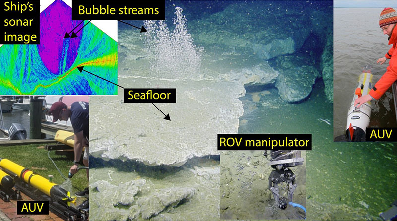
This compilation of images provides a visual introduction to this project. Clockwise from left: bubble streams detected in sonar data, bubble streams escaping from the seafloor, a REMUS 100 autonomous underwater vehicle (AUV), temperature measurements being taken by remotely operated vehicle (ROV) at a seep site, and the VT-690 AUV. Images courtesy of Ocean Exploration Trust (ROV captures) and NOAA Pacific Marine Environmental Laboratory (sonar image). Download largest version (jpg, 771 KB).
Exploring Attu’s Underwater Battlefield and Offshore Environment
Principal Investigator: Jason Raupp, East Carolina University
Attu in Alaska’s Aleutian Islands is the site of the only World War II (WWII) battle fought on North American soil. In 2019, the Attu Battlefield and associated airfields were incorporated into the Aleutian Islands WWII National Monument. Nevertheless, few people know about the battle, the larger campaign, or their significance to the nation, and Attu’s underwater battlefield is completely undocumented. To bring attention to this chapter in U.S. history, this research team will inventory Attu’s maritime heritage sites. To do so, they will use an innovative synthetic aperture sonar system both towed behind a research vessel and deployed on an uncrewed underwater vehicle to map the seafloor and detect targets. A remotely operated vehicle will be used to capture follow-up video and still photographs. In addition to discovering and documenting WWII maritime heritage sites, this team also seeks to answer questions about Attu’s pre-war maritime history and hire Alaska Native consultants to contribute to our understanding of Attu’s marine environment and the Unangax^ (oo-naan-gah) / Sasignan population displaced by the U.S. government during the war. Finally, this work will provide a foundation for further work to locate missing in action U.S. and Japanese service personnel.
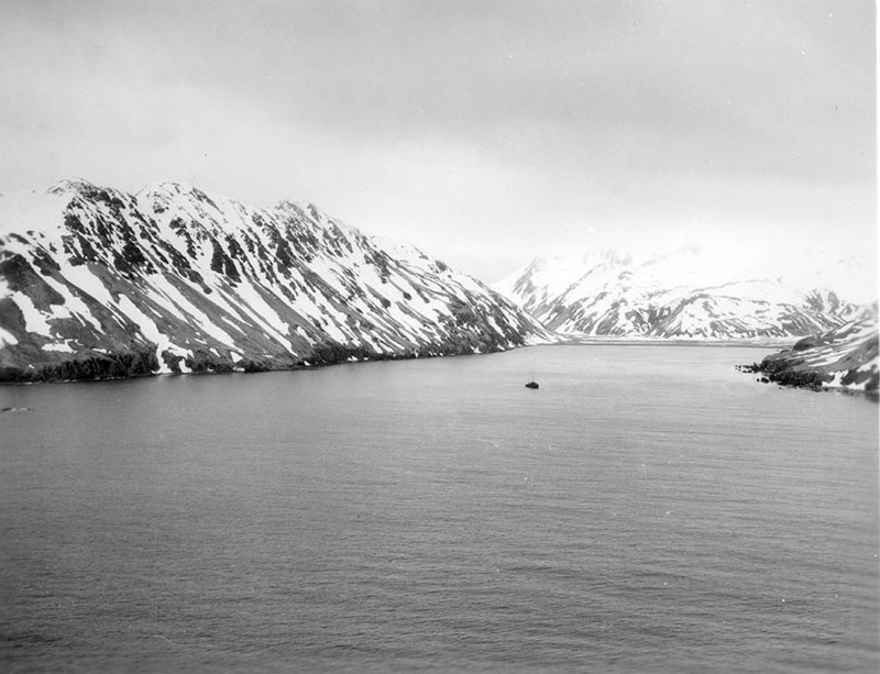
This photograph of Attu’s Holtz Bay was captured by a serviceman stationed on the island during World War II. Image courtesy of the National Archives. Download largest version (jpg, 198 KB).
Exploring the Biodiversity of Remote Pacific Ocean Deep-Sea Coral Communities With eDNA
Principal Investigator: Meredith Everett, NOAA Northwest Science Fisheries Center
Deep-sea corals and the animals that live among them are an important component of community biodiversity in the deep-sea worldwide. Despite the growing interest in resource development in the deep ocean, there has been little research on the impacts it may have on deep-sea benthic communities. And, since they’re difficult to access, they’re difficult to study. This research team will use environmental DNA (eDNA) and voucher specimens collected from deep waters around remote islands and seamounts in the Pacific to improve our understanding of the biodiversity and biogeographic boundaries of deep-sea coral communities in the remote tropical region of the Pacific. Their work will involve identifying deep-sea coral species from voucher specimens, developing an eDNA reference database using these specimens, and using this database to analyze eDNA samples collected in deep-sea coral communities across the region. This work will provide protocols and baseline data, which will facilitate further exploration and research and inform management of marine protected areas in the region.
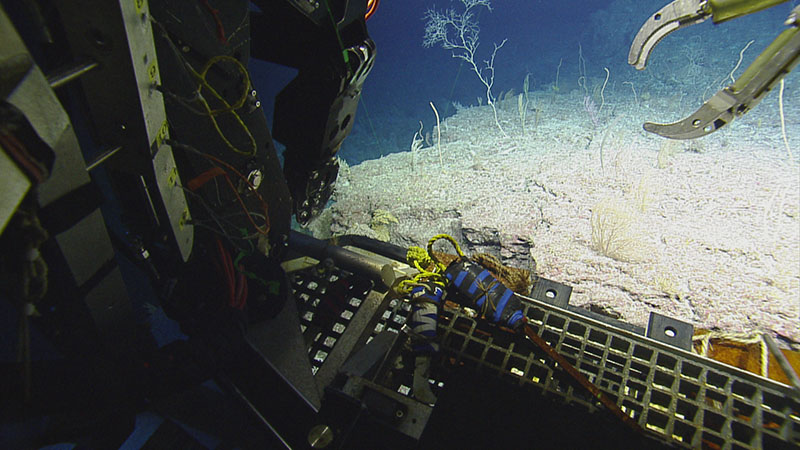
During an expedition to Baker and Howland Islands and Johnston Atoll aboard Exploration Vessel Nautilus in 2019, scientists collected environmental DNA, which will be analyzed as part of this project. Image courtesy of Ocean Exploration Trust. Download largest version (jpg, 1.4 MB).
Exploring Deepwater WWII Battlefields in the Pacific Using Emerging Technologies
Principal Investigator: Jennifer McKinnon, Ships of Exploration and Discovery Research, Inc.
The U.S. victory over Japan in the Battle for Saipan in the Northern Mariana Islands in 1944 was a decisive moment for World War II (WWII) in the Pacific. Today, the landing beaches for the U.S. invasion are part of a U.S. National Historic Landmark District. Despite their significance, the subsea remains of the battle (shipwrecks, tanks, amphibious vehicles, aircraft, and more) remain unexplored. This research team will use emerging technologies to locate, explore, and characterize the offshore battlefield’s maritime heritage resources. They will apply artificial intelligence to lidar data to locate and identify these resources and use remotely operated vehicle photogrammetric modeling to document them. In addition, at each site they will collect environmental DNA to better understand its biodiversity and employ military veteran divers, as part of a citizen science rehabilitative therapy training program, to gather the data. The results of this project will help marine resource managers understand the socioeconomic value of these important archaeological and biological resources (e.g., for tourism and fisheries) and increase public appreciation and understanding of WWII maritime heritage.
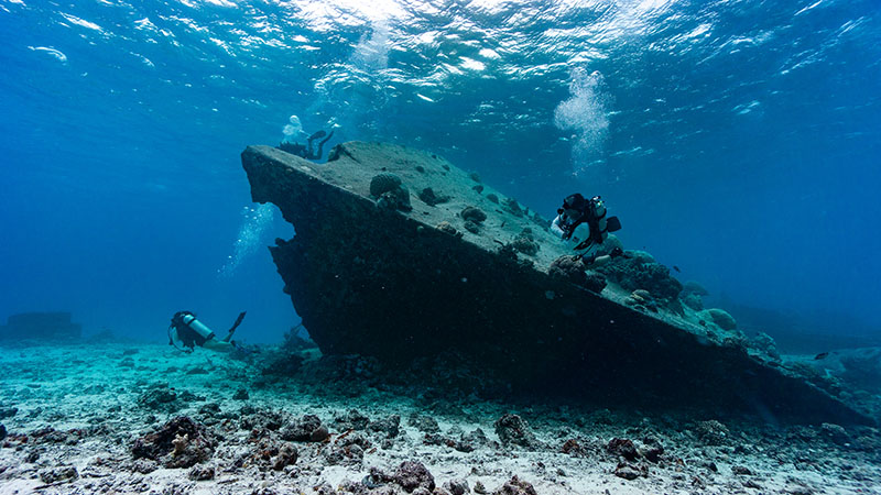
Task Force Dagger Foundation veteran divers inspect the bow of the sunken World War II Japanese shipwreck Shoan Maru. It carried conscripted Korean soldiers when it was sunk by the U.S. military in the harbor in Saipan. Image courtesy of Nicole Grinnan. Download largest version (jpg, 5.3 MB).
Exploring Pelagic Biodiversity of the Gulf of Alaska and the Impact of Its Seamounts
Principal Investigator: Russ Hopcroft, University of Alaska, Fairbanks
The northern Gulf of Alaska is a region of high productivity and supports some of the nation’s largest commercial fisheries. But, ocean warming and deoxygenation are raising concerns about the future of the region’s poorly understood deep waters and the fish and invertebrates that live there. This research team has devised a novel, multipronged exploration program to investigate the diversity and distribution of these deep-ocean animals. Building on previous work, their program includes acoustic, photographic, video, and physical and molecular (DNA) inventories of the small animals (zooplankton and micronekton) in the water column, like fish, crustaceans, gelatinous animals, and squid. Special attention will be given to how seamounts and changing biomass of gelatinous animals (due to a warming ocean) impact water column communities. By integrating state-of-the-art acoustic sensing and sampling methods, including a towed imaging system, this project will add to our understanding of the ecology of the northern Gulf of Alaska, the connections between its shelf and ocean habitats, and its response to changing conditions. It will also help us better manage the important resources provided by the region.
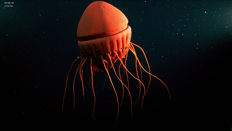
About the size of a large melon, the cornate jellyfish Periphyllopsis braueri is among the most majestic inhabitants of the poorly known deepwater communities in the Gulf of Alaska. Image courtesy of NOAA/UAF/Oceaneering. Download largest version (jpg, 2.9 MB).
Guam: A Biogeographic and Maritime Cultural Landscape Exploration of a WWII Amphibious Battlefield
Principal Investigator: Anne Wright, National Park Service Submerged Resource Center
During World War II (WWII), Guam was a strategic military location for both the United States and Japan. In July 1944, U.S. troops invaded and secured the Japanese-held island. There has not been a comprehensive inventory of the submerged resources related to the invasion, but evidence suggests there is likely a significant amount of WWII-related cultural resources on the seafloor near the landing beaches of Asan and Agat (now units of War in the Pacific National Historical Park). This research team will use autonomous underwater and remotely operated vehicles and divers to identify, map, and document submerged resources related to the invasion (e.g., shipwrecks, aircraft, amphibious vehicles, and artillery). They will also assess war-related impacts on the coast, seafloor, and barrier coral reef to investigate how damage to the reef may have impacted the island’s ecosystem and coastal vulnerability. This project will further our understanding of one of the most significant invasions of the WWII Pacific theater as well as how it may have shaped the natural environment in the area today.
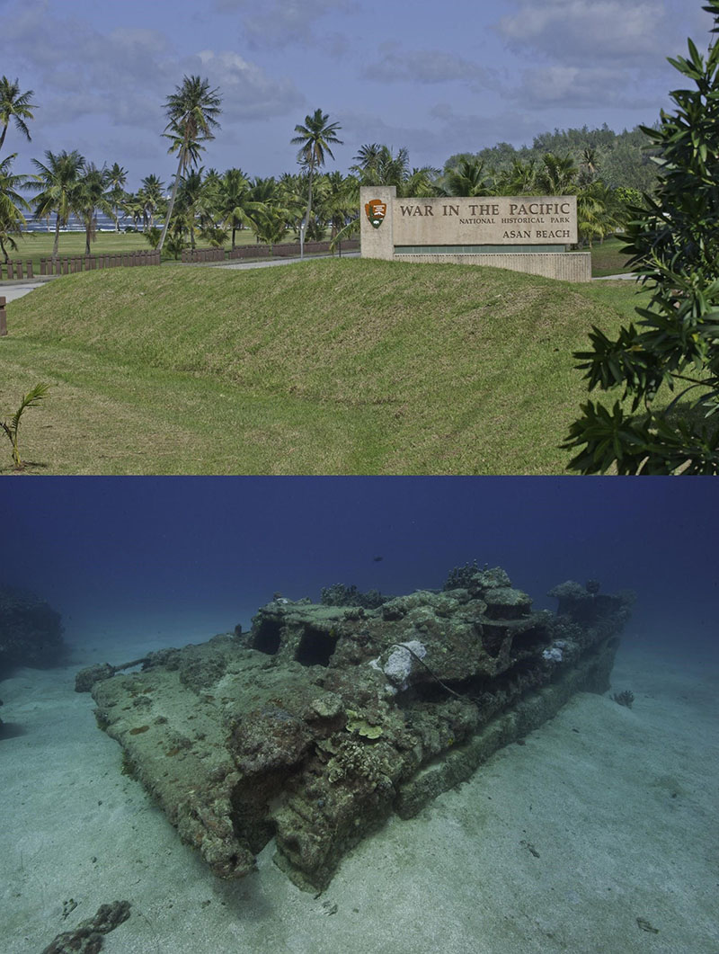
Previous work of the National Park Services’ Submerged Resource Center at War in the Pacific National Historical Park sets the stage for this project, which aims to improve understanding of the historic context and natural impacts of World War II in the region. Images courtesy of National Park Services. Download largest version (jpg, 1.4 MB).
Machine Learning-Based Automated Detection of Seafloor Gas Seeps
Principal Investigator: Adam Skarke, Mississippi State University
Seafloor gas seeps are hotspots of deep-sea biodiversity, an important part of the global carbon cycle, indicators of potential marine geohazards, and an energy production resource. However, the deep ocean is largely unexplored, and most seeps are discovered through manual visual analysis of water column sonar imagery, which is time consuming, costly, and inconsistent, so a lot remains to be learned about their extent, abundance, and contribution to global scale processes. Recognizing the importance of seeps and the significant potential for further seep discovery, this research team will develop an efficient and cost-effective machine learning-based software system to automatically detect gas seeps in mapping sonar water column data. The system, trained and validated using a database of known seeps, will allow detection of seeps in newly collected or archived multibeam sonar water column data and has the potential to rapidly advance the scope and efficiency of global seafloor seep discovery in support of ocean research, resource management, and economic development.
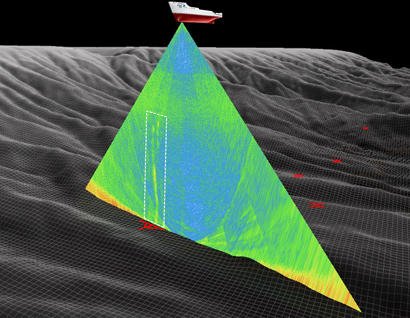
This project’s machine learning-based software system will automatically detect and segment gas bubble plumes (yellow-green vertical linear features within white dashed box) in mapping sonar water column data (triangular fan under ship). The system will use the resulting segmented sonar data to estimate the location of gas seeps on the seafloor (red targets). Image courtesy of Adam Skarke using bathymetric and water column data collected by NOAA Ocean Exploration. Download largest version (jpg, 2.1 MB).
Published July 1, 2022