A key purpose of NOAA’s Ocean Exploration Initiative is to investigate the more than 95 percent of Earth’s underwater world that until now has remained virtually unknown and unseen. Such exploration may reveal clues to the origin of life on Earth, new knowledge about the forces that cause natural hazards such as volcanoes and earthquakes, cures for human diseases, answers on how to achieve sustainable use of resources, and information to protect endangered species.
During the summer of 2010, scientists from Indonesia and the United States will work together on an expedition to explore the deep ocean surrounding Indonesia. This mission is called INDEX SATAL 2010, since the expedition is focused on INDonesia, EXploration, and the Sangihe Talaud (SATAL) region. Working from the Indonesian Research Vessel Baruna Jaya IV and the NOAA Ship Okeanos Explorer, these ocean explorers expect to find new deep-sea ecosystems, undiscovered geological features, and living organisms that have never been seen before. New discoveries are always exciting to scientists; but information from ocean exploration is important to everyone, because:Biodiversity in deep sea ecosystems includes new species that can provide important drugs and other useful products;
Indonesia is well-known as one of Earth’s major centers of biodiversity (which means the variety of all forms of life). Although Indonesia covers only 1.3 percent of Earth’s land surface, it includes:
Some of the reasons for this extraordinary biodiversity are discussed below in “More About Indonesia’s Biodiversity.” Very little is known about Indonesia’s deep ocean, but scientists expect that biodiversity may be high there as well, along with new ecosystems and many species that have never been seen before.
Conditions in the deep-sea environment include very high pressures, total darkness, extreme temperatures, and toxic chemicals. Hydrothermal vents, for example, are deep ocean habitats where hot fluids erupt from the seafloor. These habitats are found near mid-ocean ridges where Earth’s tectonic plates are spreading apart. The ridges are formed by hot lava that erupts between spreading tectonic plates. Hydrothermal vents are produced when cold seawater seeps down into Earth’s crust through cracks in the ocean floor near mid-ocean ridges. As the seawater moves deeper into the crust, it is heated by molten rock. As the temperature increases, sulfur and metals such as copper, zinc, and iron dissolve from the surrounding rock into the hot fluid. Eventually, the mineral-rich fluid rises again and erupts from openings in the seafloor. The temperature of the erupting fluid may be as high as 400°C, and contains hydrogen sulfide. When the hot hydrothermal fluid meets cold (nearly freezing) seawater, minerals in the fluid precipitate. The precipitated mineral particles give the fluid a smoke-like appearance, so these vents are often called black smokers or white smokers, depending upon the types of minerals in the fluid. Precipitated minerals may also form chimneys that can be several meters high.
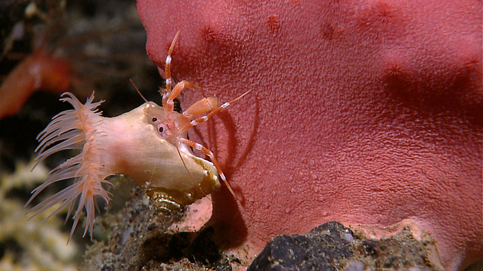
The conditions around hydrothermal vents would be deadly to humans and many other species, but deep ocean explorers have found living organisms with special adaptations that allow them to thrive in the deep-sea environment. Some of these adaptations produce new drugs and other useful products. At present, almost all drugs produced from natural sources come from terrestrial plants, but marine organisms produce more drug-like substances than any group of organisms that live on land. Some chemicals from microorganisms found around hydrothermal vents (the exopolysaccharide HE 800 from Vibrio diabolicus) are promising for the treatment of bone injuries and diseases, while similar chemicals may be useful for treating cardiovascular disease. Other examples of useful products include Thermus thermophylus is a microorganism that is adapted to live under extremely high temperature conditions near hydrothermal vents. One of these adaptations is a protein (Tth DNA polymerase) that can be used to make billions of copies of DNA for scientific studies and crime scene investigations. Another microorganism (genus Thermococcus) produces a type of protein (an enzyme called pullulanase) that can be used to make sweeteners for food additives.
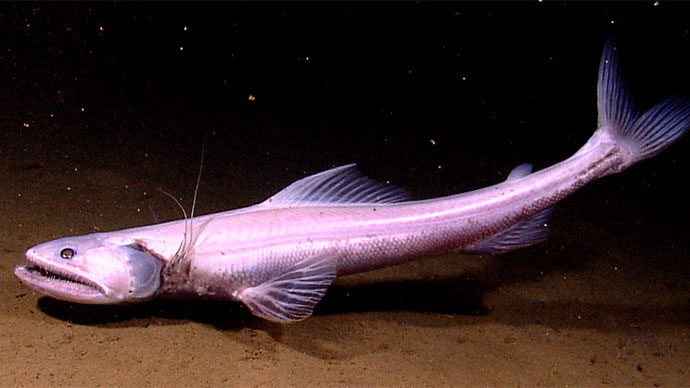
High biodiversity in some deep-sea ecosystems also includes fishes that can be used for human food. Seamounts, for example, are undersea mountains that are usually the remains of submarine volcanoes. They rise more than 1,000 m from the deep ocean floor and are entirely underwater. Seamount slopes are very steep, and produce current patterns that bring nutrients from deeper waters. These nutrients enhance the growth of marine plants that support complex food webs in the vicinity of seamounts.
Most deep-water fishes are not considered commercially-important because their flesh lacks protein and has a watery consistency that makes them unattractive as food for humans. In the 1980’s, however, fishermen discovered large populations of deep water fishes living around seamounts. These fishes had firm, tasty flesh and high protein and lipids content. Moreover, these fishes were ten times more abundant than other deep-water fishes in neighboring areas. Unfortunately, many seamount species have been overfished by industrial fishing gear such as bottom trawls. Seamount fish populations may be managed for smaller scale artisanal fisheries that are sustainable and still provide food and economic benefits for local communities. This type of management depends upon information on deep sea ecosystems and populations that can come from deep ocean exploration.
The geology of the seafloor around Indonesia is very complex and active. Active geology means that the land and seafloor of Indonesia frequently experience volcanoes, earthquakes, and tsunamis. Volcanoes in Indonesia have caused more human fatalities and generated more tsunamis than any other volcanic region on Earth. The reason for this geologic activity is that Indonesia is located at the junction of several tectonic plates that make up Earth’s crust. Collisions between these plates cause volcanoes and earthquakes, and may also cause tsunamis (for additional discussion, see “More About Tectonic Plate Movements,” below).
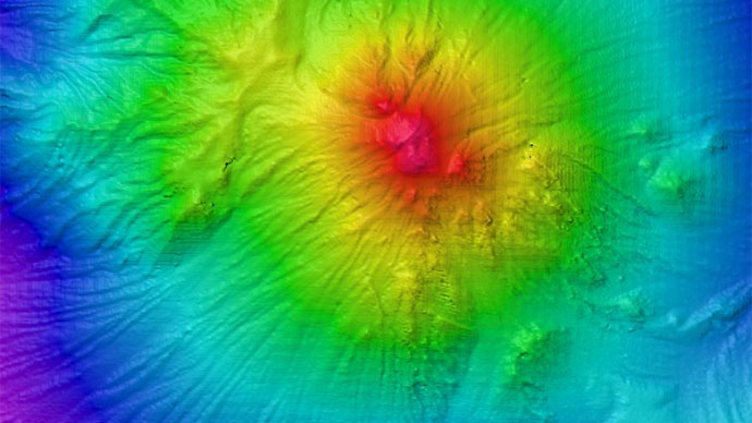
On a global scale, Earth’s crust seems to be divided into 14 large plates (Figure 1). At this scale, Indonesia is located at the junction of the Eurasian, Pacific, India, and Australian Plates. In many places, including Indonesia, there are also many smaller plates that make the geology much more complex. Figure 2 illustrates some of these smaller plates. The India and Australian Plates are pushing underneath the Burma and Sunda Plates, forming an arc of volcanoes in western Indonesia. To the east, several smaller plates collide in various ways that also produce earthquakes and volcanoes.
Motion between these plates is not constant, because friction between the plates tends to keep them from moving. But while they are not moving, tectonic forces cause stresses to accumulate in the upper plate which gradually becomes deformed. Stresses may accumulate over centuries, until the deformation suddenly releases causing the plate to rebound. This plate motion produces an earthquake, as well as a giant underwater “kick” that generates a tsunami. The Banda Aceh earthquake and tsunami on December 26th, 2004 was caused by a sudden slip when the India Plate slid beneath the Burma Plate.
The 2003 Ocean Explorer Puerto Rico Trench Expedition mapped deformation patterns in the Caribbean tectonic plate, and these patterns were used to predict earthquake and tsunami hazards. Similar information from Indonesia’s deep ocean can be used to help prepare for these hazards.
Earth’s average temperature is now warmer than it has been at any time since at least 1400 AD. It is important to remember that averages include numbers that are higher and lower than the “average” value. So the warming in some areas can be much higher than the average while other areas may actually be cooler. Debate continues about the causes of climate change, but it is clear that:
Sea level rise makes coastal communities more vulnerable to storms and flooding. Another concern for Indonesia is the effect of higher temperatures on coral reefs. Many scientists believe that the health of many coral reefs is declining because of multiple stresses, one of which is increased water temperature.
While the deep ocean might seem to be far away from the atmosphere, deep sea currents transport heat between all of the world’s oceans. This deep ocean circulation is sometimes called the “global conveyor belt,” and has a significant influence on Earth’s climate. Some scientists are concerned that warmer temperatures at the ocean surface and increased freshwater inflow from melting ice may weaken the global conveyor belt. Ocean exploration can provide some of the essential knowledge about ocean-atmosphere interactions that is needed to understand, predict, and respond to these impacts. For more information about the “global conveyor belt,” see the Okeanos Explorer “Why Do We Explore” Leaders Guide, page 18.
Interaction between Earth’s ocean and atmosphere is producing another stress that affects many marine organisms. Carbon dioxide in Earth’s atmosphere has been increasing for many years, and this has caused more carbon dioxide to be dissolved in the ocean. This increase in dissolved carbon dioxide is causing ocean waters to become more acidic. Increased acidity leads to a decrease in carbonate ions that are essential to the process of calcification through which many organisms produce shells and other skeletal structures (for more details, see “More About pH and the Carbonate Buffer System,” and the Ocean Explorer Lophelia 2008 mission logs.) In addition to corals, shellfish, echinoderms, and many marine plankton also build body parts through calcification. Pteropods are planktonic snails that are an important component of food webs in high-latitude regions, and have been shown to have pitted or partially dissolved shells in waters where carbonate ions are depleted.
Major technologies that may be used to answer these questions include:
Multibeam Sonar
Sonar (which is short for SOund NAvigation and Ranging) systems are used to determine water depth, as well as to locate and identify underwater objects. In use, an acoustic signal or pulse of sound is transmitted into the water by a sort of underwater speaker known as a transducer. The transducer may be mounted on the hull of a ship, or may be towed in a container called a towfish. If the seafloor or other object is in the path of the sound pulse, the sound bounces off the object and returns an “echo” to the sonar transducer. The time elapsed between the emission of the sound pulse and the reception of the echo is used to calculate the distance of the object. Some sonar systems also measure the strength of the echo, and this information can be used to make inferences about some of the reflecting object’s characteristics. Hard objects, for example, produce stronger echoes that softer objects. This is a general description of “active sonar”. “Passive sonar” systems do not transmit sound pulses. Instead, they “listen” to sounds emitted from marine animals, ships, and other sources.
Multibeam sonar is one of the most powerful tools available for modern deep sea exploration. A multibeam system uses multiple transducers pointing at different angles on either side of a ship to create a swath of signals. The time interval between signal transmission and return echo arrival is used to estimate depth over the area of the swath. In some systems, the intensity of the return echo is also used to infer bottom characteristics that can be used for habitat mapping. In addition to high-resolution maps, multibeam data can be used to create three dimensional models or even “fly-by” videos that simulate a trip across the area being mapped. Click here for a fascinating example. This 3D fly-through movie shows the seafloor in the Magic Mountain area of Explorer Ridge (near the coast of ) where there are active hydrothermal vents. To see what the vents look like, you can view other fly-throughs of the same area. Recently, a new generation of multibeam sonars has been developed that are able to map features in the water column as well as the seafloor. This ability will potentially allow multibeam sonars to map the location of fish and marine mammals, as well as a wide range of physical oceanographic processes. Learn more about sonar systems.
CTD
CTD stands for conductivity, temperature, and depth, and refers to a package of electronic instruments that measure these properties. Conductivity is a measure of how well a solution conducts electricity and is directly related to salinity, which is the concentration of salt and other inorganic compounds in seawater. Salinity is one of the most basic measurements used by ocean scientists. When combined with temperature data, salinity measurements can be used to determine seawater density which is a primary driving force for major ocean currents. Often, CTDs are attached to a much larger metal frame called a rosette, which may hold water sampling bottles that are used to collect water at different depths, as well as other instruments that can measure additional physical or chemical properties.
Remotely Operated Vehicles
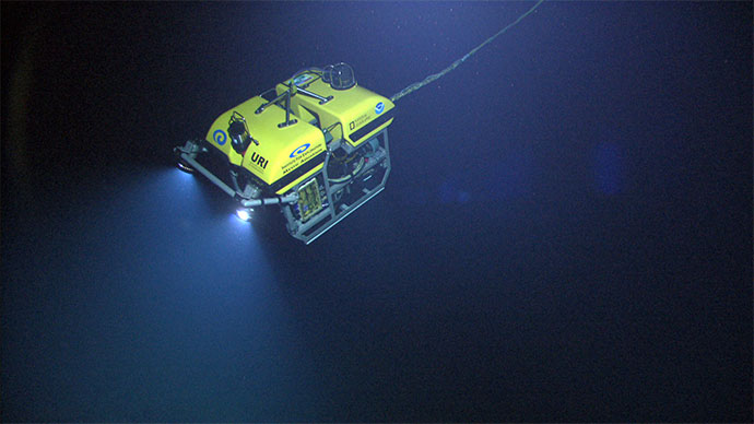
Remotely operated vehicles (ROVs) are unoccupied robots linked to an operator by a group of cables. Underwater ROVs are usually controlled by an operator aboard a surface ship. Most are equipped with one or more video cameras and lights, and may also carry other equipment such as a manipulator or cutting arm, water samplers, and measuring instruments to expand the vehicle's capabilities. For the INDEX SATAL 2010 Expedition, NOAA Ship Okeanos Explorer will carry Little Hercules, an ROV whose primary purpose is to gather high quality video imagery. Little Hercules has four thrusters and can operate as deep as 4000 meters.
More information about other ROVs.
The seas of Indonesia and the Philippines (including the Sulu, Banda, Celebes, Java, Molucca, and Halmahera Seas) are the only deep-water gap between the continental shelves of Australia and Southeast Asia. Water flowing from the Western Pacific Ocean into the Indian Ocean is channeled by numerous island chains to form a series of ocean currents known as the Indonesian Throughflow. The dominant Throughflow current passes off the southern Philippines into the Celebes Sea (which is partially enclosed by Borneo (Kalimantan) and the island of Celebes (Sulawesi)), then flows through the Makassar Strait, around Java and the Lesser Sunda Islands, and eventually becomes part of the west-flowing South Equatorial Current.
The path of the Indonesian Throughflow through the Celebes Sea coincides with an imaginary boundary known as “Wallace’s Line.” Alfred Russell Wallace was an English naturalist who spent eight years in Indonesia during the mid-1800’s studying wildlife and collecting specimens for museums. During his travels, Wallace noticed that animals on the island of Bali seemed to be related to similar species found in Asia, while animals on the Island of Lombok (only 20 miles away to the southeast) were very different and more closely resembled species in Australia. The boundary between these two “zoogeographic regions” became known as “Wallace’s Line,” and extends from the middle of the Celebes Sea, through the Makassar Strait between Borneo and Celebes, through the strait between Bali and Lombok.
This junction of two great zoogeographic regions is sometimes referred to as “Wallacea,” and is an area of particularly high biological diversity and endemism. Endemic species are species that are found nowhere else. The high number of endemic species in Wallacea is probably due to several factors:These factors help explain the diversity of terrestrial organisms on either side of Wallace’s Line; but what about marine organisms? Does Wallace’s Line also exist in the ocean environment? Recent research on the genetics of some marine species suggests that populations in the seas of Indonesia may also be biologically isolated from each other, even though strong currents would be expected to spread larvae around the region and prevent this kind of isolation.
Volcanoes and earthquakes are both linked to movements of tectonic plates, which are portions of the Earth’s outer crust (the lithosphere) about 5 km thick, as well as the upper 60 - 75 km of the underlying mantle. These plates move on a hot flowing mantle layer called the asthenosphere, which is several hundred kilometers thick (Figure 1). Heat within the asthenosphere creates convection currents that cause tectonic plates to move several centimeters per year relative to each other.
Where tectonic plates slide horizontally past each other, the boundary between the plates is known as a transform plate boundary. As the plates rub against each other, huge stresses are set up that can cause portions of the rock to break, resulting in earthquakes. Places where these breaks occur are called faults. A well-known example of a transform plate boundary is the San Andreas fault in California.
View animations of different types of plate boundaries.
A convergent plate boundary is formed when tectonic plates collide more or less head-on. When two continental plates collide, they may cause rock to be thrust upward at the point of collision, resulting in mountain-building (the Himalayas were formed by the collision of the Indo-Australian Plate with the Eurasian Plate). When an oceanic plate and a continental plate collide, the oceanic plate moves beneath the continental plate in a process known as subduction. Deep trenches are often formed where tectonic plates are being subducted, and earthquakes are common. As the sinking plate moves deeper into the mantle, fluids are released from the rock causing the overlying mantle to partially melt. The new magma (molten rock) rises and may erupt violently to form volcanoes, often forming arcs of islands along the convergent boundary. These island arcs are always landward of the neighboring trenches.
View the 3-dimensional structure of a subduction zone.
Where tectonic plates are moving apart, they form a divergent plate boundary. At divergent plate boundaries, magma rises from deep within the Earth and erupts to form new crust on the lithosphere. Most divergent plate boundaries are underwater (Iceland is an exception), and form submarine mountain ranges called oceanic spreading ridges. While the process is volcanic, volcanoes and earthquakes along oceanic spreading ridges are not as violent as they are at convergent plate boundaries. View the 3-dimensional structure of a mid-ocean ridge.
What Do pH Numbers Mean? An “acid” is commonly defined as a chemical that releases hydrogen ions (abbreviated H+). The pH (which stands for “power of hydrogen”) of a solution is defined as the negative logarithm of the hydrogen ion concentration in moles per liter. So,
pH = - log [H+]
where brackets are understood to mean “concentration”.
The logarithm of a number x is the power to which another number called the “base” must be raised to produce x. So, the logarithm of 1000 to the base 10 is 3 because 10 raised to the power of 3 is equal to 1000. Where pH is concerned, the base is always 10.
If a solution has a hydrogen ion concentration of 1 x 10⁻⁷ moles/liter, the logarithm of this concentration is -7, and the pH is 7. The pH scale ranges from 0 to 14, which corresponds to a hydrogen ion concentration range of 1.0 mole/liter to 1 x 10-14 mole/liter. A pH of 7 is considered neutral. A pH below 7 (higher hydrogen ion concentration) is acidic; a pH above 7 (lower hydrogen ion concentration) is basic.
A decrease of 0.1 pH unit may not seem like much, until we remember that this is a logarithm. So a pH of 8.2 corresponds to a hydrogen ion concentration of:
1 x 10-8.2 moles/liter = 0.00000000631 moles/liter
(10 raised to the -8.2 power)
and a pH of 8.1 corresponds to a hydrogen ion concentration of:
1 x 10-8.1 moles/liter = 0.00000000794 moles/liter
so a drop of 0.1 pH unit represents a 25.8% increase in the concentration of hydrogen ions.
Note that while the term “ocean acidification” is commonly used, the ocean is not expected to actually become acidic (which would mean that the pH was below 7.0). “Acidification” in this case only means that the pH is declining.
The Carbonate Buffer System Ð pH is a measure of acidity, which is the concentration of hydrogen ions; increasing hydrogen ions cause increased acidity; a pH of 7 is considered neutral; a pH below 7 is acidic; a pH above 7 is basic. Dissolved chemicals cause seawater to act as a pH buffer; that is, seawater tends to resist changes in pH. This “carbonate buffer system” is described by the following equation:

This equation shows that carbon dioxide dissolves in seawater to form carbonic acid, a weak acid. Most of the carbonic acid normally dissociates to form hydrogen ions, bicarbonate ions, and carbonate ions. Carbon dioxide, carbonic acid, bicarbonate ions, and carbonate ions are all present in normal seawater, although not in the same concentrations (bicarbonate and carbonate concentrations are much higher than carbon dioxide and carbonic acid). When these chemicals are in equilibrium, the pH of seawater is about 8.1 - 8.3 (slightly basic). More dissolved carbon dioxide causes an increase in hydrogen ions and a lower ocean pH. But the pH change in seawater is less than if the same amount of carbon dioxide were dissolved in fresh water because the carbonate buffer system in seawater removes some of the added hydrogen ions from solution.
But the chemical reactions that take place in this buffer system have another consequence. Bicarbonate ions form much more readily than carbonate ions, so added hydrogen ions tend to react with carbonate ions to form bicarbonate. So, adding hydrogen ions to seawater causes a decrease in carbonate ions; and carbonate ions are essential to the process of calcification through which many organisms produce shells and other skeletal structures.