by Dr. Patricia Fryer, Department of Microbiology, University of Hawaii
The northeastern region of Indonesia, just south of the Philippine islands, is made up of the islands of the Sangihe Arc on the west and the Talaud Islands ridge on the east. This is a geologically complex area of both ancient blocks of continental crust and young volcanic regions. The region has a long history of break-up of and collision between tectonic plates (blocks of the crust and upper mantle of the Earth).
The ancient continental blocks were once part of the supercontinent of Gondwana, and began to break up some 200 million years ago. Today, the region marks the boundaries between the Philippine Sea Plate, the Eurasian Plate, and the Indo-Australian Plate. Relative movements between these three large plates cause faulting and rotations within smaller blocks in the region, creating one of the most unique geologic settings on Earth.
The stage set for our expedition is intricate. The Celebes Sea is being subducted northeastward beneath southwestern Mindanao at the Cotabato Trench and southward beneath the northeastern arm of Sulawesi. Between these two trenches, the eastern edge of the Celebes Sea is riding up over the Molucca Sea Plate. In fact, the Molucca Sea Plate is being subducted both westward beneath the Sangihe Arc and eastward beneath Halmahera. This is the Earth's only example of a collision between facing volcanic arcs.
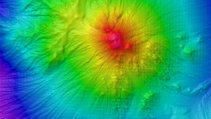
Volcanoes of the Sangihe Arc are built on the eastern edge of the Celebes Sea and erupt lavas formed as the Molucca Sea Plate is subducted into mantle realms where heat and pressure are great enough to initiate melting. Most of the recent volcanic activity in the region has been reported from the southern end of the Sangihe Arc, and the composition of lavas along the arc indicates decreasing magma generation northward. One might expect this with the change from Molucca Sea subduction beneath the Sangihe Arc to the Celebes Sea subduction beneath Mindanao in the north. Recent evidence, however, suggests there is very active volcanism going on at a submarine volcano (Kawai Barat) at the northern end of the Sangihe Arc.
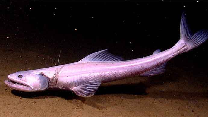
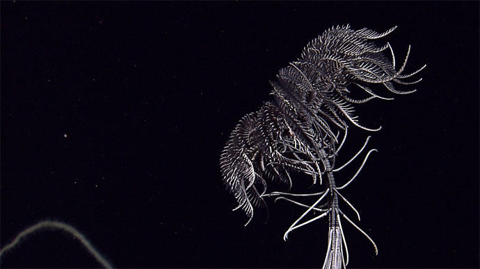
One of the objectives of our expedition is to explore the northern part of the Sangihe Arc and gather information about the distribution of volcanism and associated hydrothermal activity in the region. Another is to explore the Sangihe Trench within the Molucca Sea to understand its structures and seek likely environments for biological communities.
Between the colliding arcs, in the middle of the Molucca Sea, the ocean floor is buckling upward and has risen above sea level to form the islands of Talaud and others along the Molucca Sea’s Central Ridge. The interplay between the pop-up structures that mark the Central Ridge and its northern extension, the Miangas Ridge, are of interest for understanding the both the geologic and biologic aspects of this unique collision zone. Evidence suggests there is a structural relationship between the pop-up structures and deformation going on to the east near the Philippine Trench.
The structures of the Central Ridge appear to be offset by fault trends and underlying structures of the forearc region (between the Philippine Trench and the Central Ridge). The Philippine Trench is located about 130 kilometers east of Talaud and 100 kilometers east of Miangas. Sediment derived from Mindanao has migrated southward and accumulated along the edge of the plate overriding the subducting Philippine Sea Plate. It has formed a thick wedge of layers that have been deforming and slumping in response to the collision. Northeast-trending faults have broken the subducted Snellius Plateau that underlies the wedge of sediments. Where major faults cut the accumulating wedges of sediment above subduction zones elsewhere in the world, there are often avenues for the escape of fluids and muds from depth. Such fluid seeps can tell us about the types of reactions that are occurring within the subducting plate, can feed mud volcanoes, and can host communities of organisms that live in the extreme chemical environments these fluids produce.
Bock, Y., L. Prawirodirdjo, J. F. Genrich, C. W. Stevens, R. McCaffrey, C. Subarya, S. S. O. Puntodewo, and E. Calais (2003), Crustal motion in Indonesia from Global Positioning System Measurements, Journal of Geophysical Research, 108(B8), 2367, doi:10.1029/2001JB000324.
Widiwijayanti, C., Mikhailov, V., Diament, M., Deplus, C., Louat, R., Tikhotsky, S., Gvishiani, A., 2003. Structure and evolution of the Molucca Sea area: Constraints based on interpretation of a combined sea-surface and satellite gravity dataset. Earth Planet. Sci. Lett. 215, 135–150.
Widiwijayanti, C., C. Tiberi, C. Deplus, M. Diament, V.Mikhailov, and R. Louat (2004), Geodynamic evolution of the northern Molucca Sea area (Eastern Indonesia) constrained by 3-D gravity field inversion, Tectonophysics, 386, 203–222 .