by David Butterfield, Joint Institute for the Study of the Atmosphere and Oceans, University of Washington and NOAA/PMEL
Data from the multibeam sonar on NOAA Ship Okeanos Explorer provided a 3D image of an underwater gas plume rising 4,600 feet from the seafloor off the California Coast in 2009. Video courtesy of the NOAA Office of Ocean Exploration and Research. Download larger version (mp4, 24.8 MB).
The ocean and seafloor around Indonesia are still largely unexplored and undoubtedly hold many surprises and scientific discoveries. Indonesian waters, a seafaring commercial crossroads for centuries, are also an important oceanic crossroads between the Pacific and Indian ocean basins, a place where oceanic water masses mix and oceanic plates collide. There are many biological questions that can be answered in this area, but there are also important geological and chemical issues here. What kind of hydrothermal systems exist here, and what is their impact on the local ecology? Are there significant mineral deposits forming?
The area we have chosen to explore in this collaborative project between Indonesia and NOAA encompasses a wide range of geological features on the ocean floor, including a deep-ocean trench and a submarine volcanic arc. Overall, this region is complex, with multiple small marginal sea basins colliding and subducting. The volcanically active Sangihe Arc, extending north from our starting port city of Bitung on the northern tip of the Sulawesi peninsula, is a result of subduction of the Molucca sea basin beneath the Celebes sea basin.

Map showing the area to be explored during the INDEX 2010 expedition. The area contains extraordinary geological complexity and underwater features including the deep-ocean Phillippine Trench and volcanically active Sangihe Arc. Image courtesy of the NOAA Office of Ocean Exploration and Research, INDEX-SATAL 2010. Download larger version (jpg, 270 KB).
In this environment, we expect to find some submarine volcanic activity along and to the west of the Sangihe Arc. One hydrothermal site of interest to us, Kawio Barat, is known from joint Indonesian/Australian surveys in 2001 and 2003 [McConachy et al. 2004]. Our chemistry objective on this mission will be to detect active fluid flow from the seafloor in the form of cold seeps, hydrothermal vents, and volcanic eruptions. Relatively fine-scale bathymetric maps, combined with water column measurements, will help us locate interesting source areas on the seafloor that can be explored with the remotely operated vehicle (ROV) during this mission.
INDEX 2010 will be the very first scientific exploration mission utilizing telepresence from onboard the Okeanos Explorer. Unlike many previous expeditions, we will not have a large group of scientists on board the ship collecting and analyzing samples. Instead, we will use the tools on the Okeanos Explorer to generate digital data that can be sent back via satellite to scientists on shore, where it can be interpreted to identify key areas that deserve continued exploration. The main shipboard systems we will use include the Kongsberg EM302 multibeam bathymetric mapping system and the SeaBird 911 Conductivity-Temperature-Depth (CTD) water column profiler.

Black smoker vent in the High-Rise Field, Endeavour segment, Juan de Fuca Ridge. Metals and hydrogen sulfide combine to form dark sulfide minerals when hot fluids mix with seawater. Image courtesy of D. Butterfield, Univ. of Washington and J. Holden, Univ. Massachusetts Amherst. Download larger version (jpg, 209 KB).
The EM302 will cover significant areas of the seafloor and create maps with significantly higher resolution than the maps that are currently available. These maps will allow us to identify individual features, such as small volcanic cones, ridges, or faults. The EM302 also has the capability to see variations in density within the water column above the seafloor, and this capability will allow us to see fish and other marine life.
The EM302’s mapping capability may detect gas bubbles rising through the water from sources on the seafloor during the expedition, a capability demonstrated in one of the shakedown cruises for the Okeanos Explorer off the coast of Oregon. Gas bubbles in the waters of Indonesia could indicate that an active volcano is releasing gas from its magma chamber, as happens during active seafloor volcanic eruptions (Embley et al. 2006; Chadwick et al. 2007; Hughes-Clark et al. ); finding gas bubbles on this mission will give us a very hot target to investigate with the ROV. Scientists on board the ship and on shore will monitor the output of the EM302 system for the signature of bubbles in the water and will be prepared to respond if bubbles are found.

Sampling gas bubbles at an active volcanic vent on NW Rota-1 submarine volcano, Mariana Arc, March 2010. Yellow and white clouds are particles of elemental sulfur produced by degassing of sulfur dioxide from the erupting lava. Image courtesy of James F. Holden, UMass Amherst. Download larger version (jpg, 160 KB).

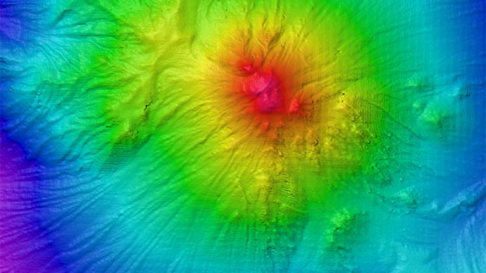
Bubble plume image captured with multibeam sonar on Kilo Moana, March 2010. The red base is the summit of NW Rota-1 volcano on the Mariana Arc. The blue semicircular disk is a swath through the water over the summit, showing the rising bubble plume as red, green, and light blue density anomalies. Image courtesy of Susan Merle, Oregon State University, NOAA Vents Program, PMEL. Download larger version (jpg, 112 KB).
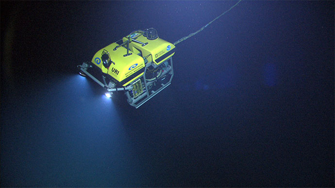
While the EM302 will map large swaths of the seafloor within our target areas, the CTD system will be used over specific seafloor features that may have active fluid flow from hydrothermal systems or cold seeps. In addition to sensing the salinity and temperature, the CTD will have sensors to detect suspended particles and oxidation/reduction potential. These additional sensors are exceptionally sensitive and are critical for detecting chemical and particle plumes in the water over features of interest. The CTD results will help to decide which targets are of highest priority to dive on with the ROV Little Hercules.
Active volcanic eruptions, for example, produce plumes dominated by yellow/white elemental sulfur accompanied by low pH due to the injection of magmatic sulfur dioxide into seawater. In contrast, mature hydrothermal systems tend to produce black metal sulfide particles, and cold seeps may produce no particles but have a significant redox signal due to high concentrations of methane or hydrogen. By filtering water samples and bringing them back to the lab on shore to analyze, we can learn something about the type of hydrothermal system without seeing it up close on the seafloor.
One of our main goals on this mission, however, is to find new hydrothermal sites on the seafloor and send back high-definition video images. In future missions, we hope to return to this crossroads area of Indonesia for more detailed exploration and sampling of some of these still undiscovered sites.
To learn more about the type of activity producing the plumes, visit: Submarine Ring of Fire 2006: Hydrothermal Plumes and Prospecting.
To learn more about the composition of vent fluids, visit: Submarine Ring of Fire 2006: The Role of Magmatic Fluids in Hydrothermal Vents on Volcanic Arcs.
Embley, R.W., W.W. Chadwick, Jr., E.T. Baker, D.A. Butterfield, J.A. Resing, C.E.J. de Ronde, V. Tunnicliffe, J.E. Lupton, S.K. Juniper, K.H. Rubin, R.J. Stern, G.T. Lebon, K.-I. Nakamura, S.G. Merle, J.R. Hein, D.A. Wiens, and Y. Tamura (2006): Long-term eruptive activity at a submarine arc volcano. Nature, 441(7092), 494–497.
Chadwick, W.W. Jr., K.V. Cashman, R.W. Embley, H. Matsumoto, R.P. Dziak, C.E.J. de Ronde, T.K. Lau, N.D. Deardorff, and S.G. Merle. (2007) Direct video and hydrophone observations of submarine explosive eruptions at NW Rota-1 Volcano, Mariana Arc., J. Geophys. Res., 113, B08S10.
McConachy, T.F., H. Permana, R.A. Binns, I. Zulkarnain, J.M. Parr, C.J. Yeats, N.D. Hananto, B. Priadi, S. Burhanuddin, and E.P. Utomo (2004) Recent investigations of submarine hydrothermal activity in Indonesia.