By Kody Kramer
and Bill Shedd,
Bureau of Ocean Energy Management - Resource Studies, Gulf of Mexico Region
April 22, 2012

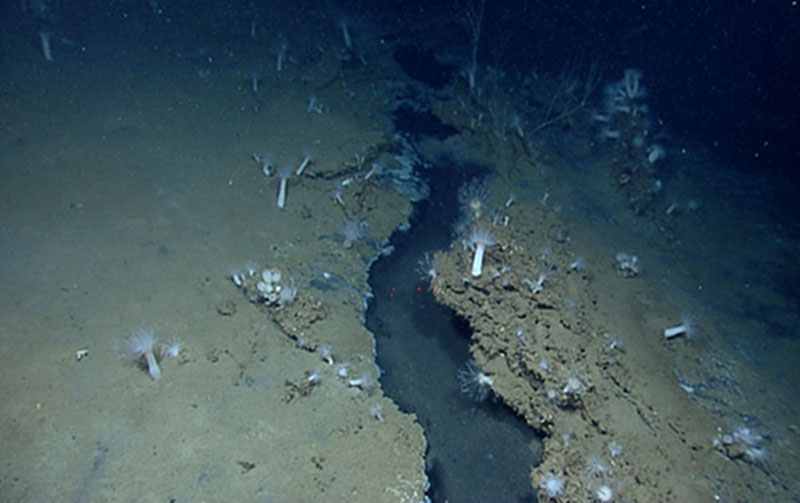
Underwater “rivers” and ponds of liquid brine were discovered at the EW915 site. When enough pressure is applied to buried salt by the overlying seafloor sediments, the salt flows, just like squeezing a tube of toothpaste. When salt squeezes up near the seafloor, it mixes with seawater and dissolves into brine, which is then brought to the seafloor by buoyant gas and oil. But, because brine is denser than seawater, it flows along the seafloor as rivers and streams, often collecting in massive pools to form brine lakes. Little Herc followed one of these crystal clear brine streams flowing within a fissure between carbonate outcrops, leading to a brine pool. Note the corals and numerous sea anemones on the banks of the river. Image courtesy of the NOAA Office of Ocean Exploration and Research, Gulf of Mexico Expedition 2012. Download larger version (jpg, 336 KB).
BOEM is studying volume estimates of oil and gas naturally released into the Gulf of Mexico, and is also interested in locating deep-water chemosynthetic and coral communities, which by regulation are protected from drilling and exploration activities of the oil industry. Kody Kramer and Bill Shedd, geoscientists from BOEM, traveled to a newly established Exploration Command Center (ECC) at Stennis Space Center, MS, to take part in the real-time video broadcast of the EW915 dive.
On Friday, the Okeanos Explorer and her tandem remotely operated vehicles (ROV), Little Hercules and Seirios, dove on a never before seen area of the seafloor in Ewing Bank block 915 (EW915), 130 miles south of New Orleans. EW915 was chosen because of its high probability for very large, natural hydrocarbon seeps, interpreted on oil industry 3-D seismic data by geoscientists at the Department of the Interior’s Bureau of Ocean Energy Management (BOEM). Video courtesy of the NOAA Office of Ocean Exploration and Research, Gulf of Mexico Expedition 2012. FridayDownload (mp4, 388 MB).
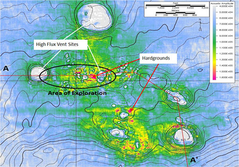
Kody and Bill used a seismic amplitude map of the seafloor to select specific dive targets which may be natural oil and/or gas seeps. The colors on this map indicate how hard the seafloor may be. Red, yellow, and green colors indicate possible areas of authigenic carbonate hardgrounds suitable as substrates for benthic communities. Light blue colors indicate where the seafloor is muddy and relatively barren, as in most of the Gulf of Mexico. Gray and white are indicators of an extremely soft seafloor, such as areas naturally charged with methane gas and oil originating from thousands of feet below.

A seismic amplitude map of the seafloor was used to select specific dive targets which may be natural oil and/or gas seeps. The colors on this map indicate how hard the seafloor may be. Image courtesy of WesternGeco. Download larger version (jpg, 755 KB).
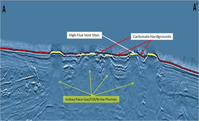
During this dive, scientists witnessed numerous instances where gas bubbles suddenly erupted from the seafloor as Little Herc passed by. A few of these seeps vented continuously, while others released bubbles intermittently. A vertical seismic cross-section showing the sedimentary layering below the seafloor along line A – A’, similar to the geologic layering seen when driving through a road cut in a hill, illustrates how the layers here are completely blanked out by pluming, column-like features. These seismic plumes are interpreted to be high flux (flow) zones of gas and salty brine which originated in the deep subsurface and migrated upward to the seafloor.

A vertical seismic cross-section showing the sedimentary layering below the seafloor along line A – A’, similar to the geologic layering seen when driving through a road cut in a hill, illustrates how the layers here are completely blanked out by pluming, column-like features. Image courtesy of WesternGeco. Download larger version (jpg, 321 KB).
Some really exciting seafloor features were also discovered at this site: underwater rivers and ponds of liquid brine. Like the Bonneville Salt Flats of Utah, salt occurs in thick layers in the Gulf of Mexico, deposited millions of years ago and subsequently buried deep under sediments washed out from North America by the Mississippi River system. However, when enough pressure is applied to salt by the overlying sediments, the salt flows, just like squeezing a tube of toothpaste.

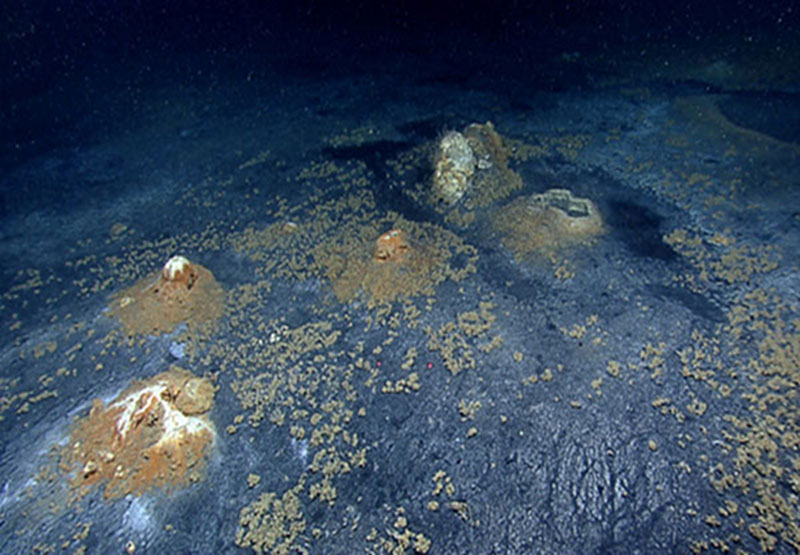
Salt “volcanoes” with oil, gas, and brine being expelled. Image courtesy of the NOAA Office of Ocean Exploration and Research, Gulf of Mexico Expedition 2012. Download larger version (jpg, 492 KB).
When salt squeezes up near the seafloor, it mixes with seawater and dissolves into brine, which is then brought to the seafloor by buoyant gas and oil. But, because brine is denser than seawater, it flows along the seafloor as rivers and streams, often collecting in massive pools to form brine lakes. There are lakes under the ocean! Little Herc followed one of these crystal-clear brine streams flowing within a fissure between carbonate outcrops, leading to a brine pool. Little Herc’s thrusters disturbed the surface of the pool, creating waves which rolled outward, lapping its “shoreline.”
Possibly the most interesting geologic features encountered were small cones of salt, expelling droplets of brine-covered oil. Here, less-dense oil migrated upwards to the seafloor through faults in the subsurface, passing through areas of brine still trapped below. As the brine-covered oil droplets escaped the seafloor and travelled upward towards the surface of the Gulf, their denser layers of brine were shed, falling back to the seafloor. Droplet by droplet, the salt slowly built up a cone around the oil seep; much like the mineral-laden waters being expelled at Yellowstone National Park which form similar, even more massive structures. The base of these cones were covered by a brown, unknown mineral, while the top was white, giving the appearance of snow-capped mountains (yet, only a few inches tall).
EW915 was truly an awe-inspiring site.