By Mashkoor Malik, NOAA Ocean Exploration and Research,
John Doroba, Hydrographic Survey Technician - NOAA Ship Rainer,
and Lt Megan Nadeau, Operations Officer - NOAA Ship Okeanos Explorer
February 27 – March 14

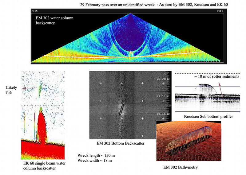
Figure 1: A known but unidentified wreck investigated by the Okeanos Explorer during her transit from Charleston, SC, to the northern Gulf of Mexico. The wreck was imaged by EM 302 MBES, EK 60, and Knudsen SBP, resulting in various distinct data sets as provided in the image. Image courtesy of the NOAA Office of Ocean Exploration and Research, Gulf of Mexico Expedition 2012. Download larger version (jpg, 627 KB).
NOAA Ship Okeanos Explorer began her second voyage of the year from Charleston, SC on February 27, 2012. The crew enjoyed a few days of rest in Charleston, SC, soaking in the history and traditions of the city, before setting sail. The ship began her six day transit towards the Northeast region of the Gulf of Mexico, during which, the ship mapped various geographic features including the continental shelf off the Carolinas and Florida, ledges, a known but unidentified wreck (Figure 1) and the Florida escarpment.

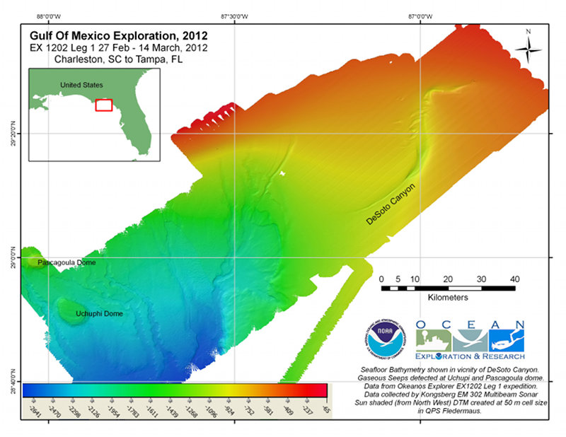
Bathymetic map of DeSoto Canyon generated at 50 meter grid cell size resolution based on preliminary data processing onboard during the expedition. Image courtesy of the NOAA Office of Ocean Exploration and Research, Gulf of Mexico Expedition 2012. Download larger version (jpg, 2.7 MB).
The ship arrived in vicinity of DeSoto canyon, the primary exploration area of this expedition, on March 4 and commenced mapping of the canyon using the Kongsberg EM 302 multibeam echosounder (EM302 MBES), Kongsberg EK 60 singlebeam fisheries echosounder (EK60), and Knudsen sub-bottom profiler (SBP).
In May 2011, NOAA’s Office of Ocean Exploration and Research held an Atlantic Basin Workshop with 50 scientists and managers to identify targets best suited for telepresence-enabled exploration by the Okeanos Explorer and E/V Nautilus. During this workshop, DeSoto canyon was identified as one of several priority exploration areas to be considered for Okeanos Explorer expeditions in the Gulf of Mexico.
The DeSoto Canyon lies approximately 100 kilometers south-southwest of Pensacola, Florida. The DeSoto Canyon’s gradual gradients and unusual S-shape makes it distinct to its counterparts in the east coast encountered earlier by the ship. The canyon cuts through the continental shelf in the northern part of the gulf, hosting an upwelling of deep nutrient-rich water and resulting in relatively high primary productivity in this area. The origin and distinct shape of the canyon has been debated to be a result of the presence of salt domes, erosion, and deposition due to bottom currents, and subsurface structure of possibly a salt ridge (Harbison, 1968). The bottom depths range from ~ 400-1,000 meters.

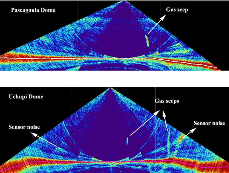
Water column targets (presumed gaseous seeps) detected over the Pascagoula and Uchupi dome during the current expedition. Image courtesy of the NOAA Office of Ocean Exploration and Research, Gulf of Mexico Expedition 2012. Download larger version (jpg, 733 KB).
DeSoto canyon has been the subject of several earlier research and exploration activities including the study of surface current (Wang et al, 2003); bottom currents (Hamilton et al, 2001); mapping the canyon heads with multibeam sonar (Gardner et al, 2003); underwater video and imagery exploration (OER expedition Operation Deep Scope, 2004); and seismic reflection surveys (Harbison, 1968). Despite these previous efforts, no publicly available multibeam data existed over the northern part of the canyon prior to this expedition. Therefore, the focus of our exploration was to produce a high resolution bathymetric map of the canyon which is expected to aid in further research and exploration planning efforts in the area. Additionally, the EM 302 MBES and EK 60 water column data that were collected around the clock will be used to detect anomalies such as assemblages of biomass or gaseous seeps (Gulf of Mexico 2011).
High-resolution bathymetry and water column data are expected to provide scientists new insights into distribution of the gaseous seeps and benthic habitats. For example, data collected during this cruise will be used during the upcoming OER ROV exploration cruises and research cruises being planned in the vicinity of the DeSoto Canyon by Florida State University later in March 2012. We are currently processing the vast amount of data collected during this cruise and all the data are expected to be available via the National Geophysical Data Center 3-6 weeks after the cruise.
The ship completed her mapping of the DeSoto canyon on March 12, 2012, and arrived in Tampa, FL, on March 14, 2012 where a crew change will bring Okeanos Explorer ROV team onboard to conduct the Leg II (3/19-4/7/12) and Leg III (4/11-4/29/12) of this expedition.
Gardner, J.V, J. E. Hughes Clarke, L. A. Mayer, and P. Dartnell, 2003: Bathymetry and Acoustic Backscatter of the Mid and Outer Continental Shelf, Head of De Soto Canyon, Northeastern Gulf of Mexico, U.S. Geological Survey Open-File Report 03–7. http://geopubs.wr.usgs.gov/open-file/of03-007/
Wang, D.-P., L.-Y. Oey, T. Ezer, and P. Hamilton, 2003: Near-surface currents in DeSoto Canyon (1997–99): Comparison of current meters, satellite observation, and model simulation. J. Phys. Oceanogr., 33, 313–326.
Hamilton, P., and A. Lugo-Fernandez, 2001: Observations of high speed deep currents in the northern Gulf of Mexico. Geophys. Res. Lett., 28, 2867-2870.
Harbison, R.N, 1968: Geology of DeSoto Canyon, Journal of Geophysical Research, Vol. 73, No. 16, August 15, 1968.