by Tim Shank, Woods Hole Oceanographic Institution
Andrea Quattrini, Temple University
Meme Lobecker, NOAA Office of Ocean Exploration and Research
August 2, 2013
 and cup corals.")
Diverse deep-sea coral and sponge habitats were imaged in the canyons explored during the Northeast U.S. Canyons 2013 Expedition. In this image from Hydrographer Canyon, a rock face is shown with a diversity of octocorals (soft corals and sea fans) and cup corals. Image courtesy of the NOAA Office of Ocean Exploration and Research, Northeast U.S. Canyons Expedition 2013. Download larger version (jpg, 1.4 MB).
From July 8-25, the Northeast U.S. Canyons 2013 Expedition explored diverse habitats and geological settings of the deep canyons region off the Northeast United States. The remotely operated vehicle Deep Discoverer (ROV D2) completed 16 dives to depths ranging from 500 to 2,200 meters along the continental slope of the northeast U.S. Focused exploration of the deep seafloor occurred between Block to Hydrographer Canyons. D2 surveyed four major submarine canyons, including Block, Alvin, Atlantis, and Hydrographer; one unnamed minor canyon; three priority sites considered to be geohazard areas; and three potential (and confirmed) hydrocarbon seep areas.
Exploration of the canyons revealed that they are likely more dynamic, both geologically and biologically, than previously thought and that each canyon may have its own signature geological and biological character over the depths examined. Specifically, each dive documented a different suite of biological and geological features. Rock morphology and size differed widely among many dives.
Initial impressions of this exploration also reveal these canyons to be hotspots for biodiversity, putatively hosting more than 25 species of corals; more than seven species of sponges; more than 30 species of fishes; and dozens of crustacean (e.g., crabs, lobsters, barnacles, shrimp), cephalopod (squids and octopus), and echinoderm species (e.g., starfish, sea urchins, sea cucumbers). Notable were the numerous fauna (animals) that were not previously known to occur in the area, including several species of crabs and corals.

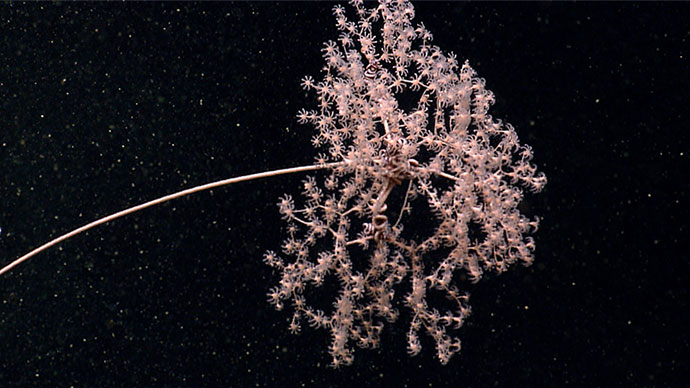
Rare stalked crinoids were observed during a deep dive in Block Canyon. Stalked crinoids were first described as fossils and were thought to be long extinct until the early 19th century. Image courtesy of the NOAA Office of Ocean Exploration and Research, Northeast U.S. Canyons Expedition 2013. Download larger version (jpg, 1.4 MB).
While exploration of this deep-water canyon system revealed that the community structure of benthic fauna was related to both depth and substrate (seafloor) type, wall failures and breaches were recognized as having a high potential for yielding unstable habitat for the establishment of hard-bottom communities.
The ROV D2 visited three sites prioritized by the U.S. Geological Survey to examine the geological formation, character, and potential instability of the seafloor, estimate relative timing of landslide events, and determine whether these areas pose a hazard to tsunami generation. Information gathered during ROV dives will be used to test hypotheses about the evolution of the features in the region and the potential for marine geological hazards (e.g., wall failures and landslides).
D2 also surveyed water column anomalies (bubble streams rising from the seafloor) to determine if methane and associated chemosynthetic communities were present. All three of these exploration dives revealed living chemosynthetic communities, e.g., beds of Bathymodiolus mussels, which hosted at least 10 species, including gastropod snails, polychaete worms, and shrimp associated with hydrocarbon seepage.
On two of the dives to seep areas, D2 imaged methane bubbling directly through sediments on the seafloor and also methane hydrates (or frozen methane), confirming that the processes that lock methane into ice occur in canyon areas in this region of the Atlantic. These cold seep areas were extensive (more than 100 meters in length).
With further examination and comparisons to the upcoming Leg 2 in additional canyon environments, exploration results of the first leg of the Northeast U.S. Canyons Expedition will continue to reveal new scientific discoveries that will enable a broad range of exciting scientific research in the future.
 shown in the photo are 10 centimeters apart and were used throughout the dive to provide scale.")
Three sites were investigated during the cruise where sonar data detected what appeared to be gas plumes in the water column. Further investigation revealed cold seeps and extensive chemosynthetic communities at all three locations. Shown in this image, chemosynthetic mussels of varying sizes were present at New England Seep Site 1. The red lasers (red dots in photo) shown in the photo are 10 centimeters apart and were used throughout the dive to provide scale. Image courtesy of the NOAA Office of Ocean Exploration and Research, Northeast U.S. Canyons Expedition 2013. Download larger version (jpg, 1.6 MB).
Throughout the cruise, previously collected multibeam data was used to plan all ROV dives. Gridded bathymetry data were viewed in collaboration with the onshore science team, and dive tracks were planned and plotted in 3D and shared with the team.

Bathymetric map summarizing operations conducted during Leg 1 of the Northeast U.S. Canyons 2013 Expedition. The grey background shows bathymetry data previous acquired by NOAA Ship Okeanos Explorer, and the colored bathymetry is new data acquired during the cruise. Also shown are the locations where ROV dives and CTD casts were conducted and XBTs were deployed to acquire data. Image courtesy of the NOAA Office of Ocean Exploration and Research, Northeast U.S. Canyons Expedition 2013. Download larger version (jpg, 468 KB).
Each night while most of the crew and scientists were sleeping, the survey department kept the ship busy conducting mapping operations. Though much of the area explored was mapped during previous cruises, more than 7,200 square kilometers were mapped during leg 1, including:
At at least one site where sonar data discovered gas plumes in 2012, water column data revealed that precise locations showing bubble release were no longer actively releasing bubbles, and that new locations in the local vicinity were now showing active plumes.
Additionally, subbottom data was acquired over targets selected in collaboration with scientists from the U.S. Geological Survey's Methane Hydrates and Marine Hazards Program.
All data collected by the mapping department of the NOAA Ship Okeanos Explorer is available to the public and can be obtained by contacting oar.oer.exmappingteam@noaa.gov.
Below is a collection of highlight images from Leg 1, some that have been previously featured on the website, some that have not.
 team members onboard NOAA Ship Okeanos Explorer prep the ROV Deep Discoverer and Camera Sled Seirios for the next dive.")
Remotely operated vehicle (ROV) team members onboard NOAA Ship Okeanos Explorer prep the ROV Deep Discoverer and Camera Sled Seirios for the next dive. Image courtesy of the NOAA Office of Ocean Exploration and Research, Northeast U.S. Canyons Expedition 2013. Download larger version (jpg, 1.6 MB).

An octopus guards her eggs under an overhang in Hydrographer Canyon. Image courtesy of the NOAA Office of Ocean Exploration and Research, Northeast U.S. Canyons Expedition 2013. Download larger version (jpg, 1.4 MB).

Corals, including cup corals and bubblegum corals reside on the hard substrate near the edge of the mussel bed. Image courtesy of the NOAA Office of Ocean Exploration and Research, Northeast U.S. Canyons Expedition 2013. Download larger version (jpg, 1.6 MB).

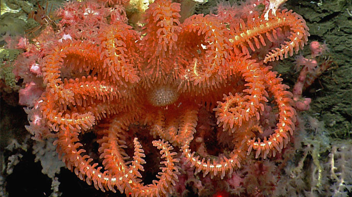
Close up of a brisingid sea star. Image courtesy of the NOAA Office of Ocean Exploration and Research, Northeast U.S. Canyons Expedition 2013. Download larger version (jpg, 1.5 MB).
 with the brittle star Ophicocreas oedipus. This pair were previously only known on the seamounts in this region.")
In a Atlantis Canyon, there were multiple observations of the obligate pair, M. melanotrichos (soft coral) with the brittle star Ophicocreas oedipus. This pair were previously only known on the seamounts in this region. Image courtesy of the NOAA Office of Ocean Exploration and Research, Northeast U.S. Canyons Expedition 2013. Download larger version (jpg, 1.2 MB).

A brittle star rests on a potentially new species of black voral. Brittle star/coral associations were common throughout the canyons investigated during this expedition. Image courtesy of the NOAA Office of Ocean Exploration and Research, Northeast U.S. Canyons Expedition 2013. Download larger version (jpg, 1.3 MB).

Amongst the diverse coral community along Hydrographer Canyon, ROV Deep Discoverer observed a glass sponge containing cephalopod eggs. Look closely—one might be hatching! Image courtesy of the NOAA Office of Ocean Exploration and Research, Northeast U.S. Canyons Expedition 2013. Download larger version (jpg, 1.4 MB).

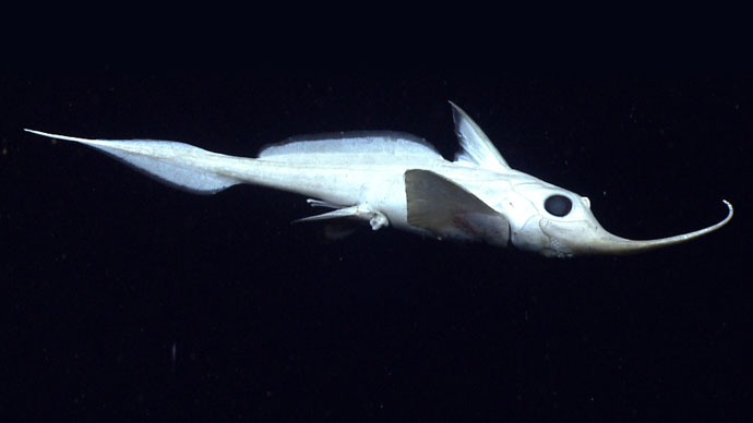
A Rhinochimera swims 10 meters above the sea floor in Hydrographer Canyon. Image courtesy of the NOAA Office of Ocean Exploration and Research, Northeast U.S. Canyons Expedition 2013. Download larger version (jpg, 974 KB).
 moves across the seafloor as ROV Deep Discoverer explores Veatch Canyon.")
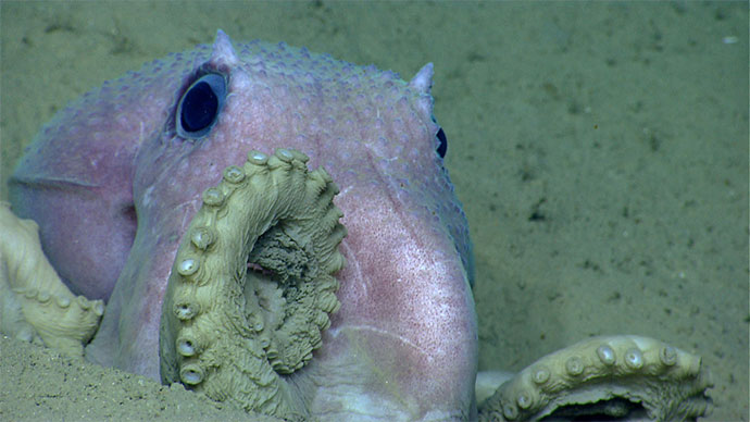
A baby octopus (Graneledone verrucosa) moves across the seafloor as ROV Deep Discoverer explores Veatch Canyon. Image courtesy of the NOAA Office of Ocean Exploration and Research, Northeast U.S. Canyons Expedition 2013. Download larger version (jpg, 1.3 MB).

A bathysaurus was observed in Veatch Canyon. These fish use their lower jaw to scoop in sand. Image courtesy of the NOAA Office of Ocean Exploration and Research, Northeast U.S. Canyons Expedition 2013. Download larger version (jpg, 1.2 MB).

A king crab explores the soft sediment. Image courtesy of the NOAA Office of Ocean Exploration and Research, Northeast U.S. Canyons Expedition 2013. Download larger version (jpg, 1.3 MB).

Several different fish species, including this Gaidropsarus peaking out from under a carbonate rock, were observed during the expedition. Image courtesy of the NOAA Office of Ocean Exploration and Research, Northeast U.S. Canyons Expedition 2013. Download larger version (jpg, 1.2 MB).

Percy, a bobtail squid, was one of the cutest cephalopods seen on the first leg and became the unofficial mascot of the expedition for mission personnel on board NOAA Ship Okeanos Explorer. Image courtesy of the NOAA Office of Ocean Exploration and Research, Northeast U.S. Canyons Expedition 2013. Download larger version (jpg, 1.5 MB).

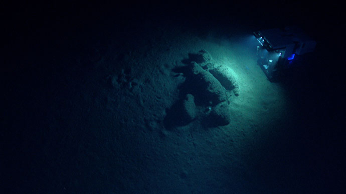
ROV Deep Discoverer explores the geomorphology of Block Canyon. Image courtesy of the NOAA Office of Ocean Exploration and Research, Northeast U.S. Canyons Expedition 2013. Download larger version (jpg, 1.1 MB).

A skate rests vertically along the wall of Atlantis Canyon. Image courtesy of the NOAA Office of Ocean Exploration and Research, Northeast U.S. Canyons Expedition 2013. Download larger version (jpg, 1.7 MB).

Three sites were investigated during the cruise where sonar data detected what appeared to be gas plumes in the water column. Shown in this image, chemosynthetic mussels of varying sizes were present at New England Seep Site 1. Image courtesy of the NOAA Office of Ocean Exploration and Research, Northeast U.S. Canyons Expedition 2013. Download larger version (jpg, 1.4 MB).

ROV Deep Discoverer is recovered after a successful dive at Block Canyon. Image courtesy of the NOAA Office of Ocean Exploration and Research, Northeast U.S. Canyons Expedition 2013. Download image (jpg, 75.6 KB).

Dr. Brendan Roark preps the CTD rosette onboard NOAA Ship Okeanos Explorer. Image courtesy of the NOAA Office of Ocean Exploration and Research, Northeast U.S. Canyons Expedition 2013. Download larger version (jpg, 1.3 MB).