By Derek Sowers, Physical Scientist - NOAA Office of Ocean Exploration and Research

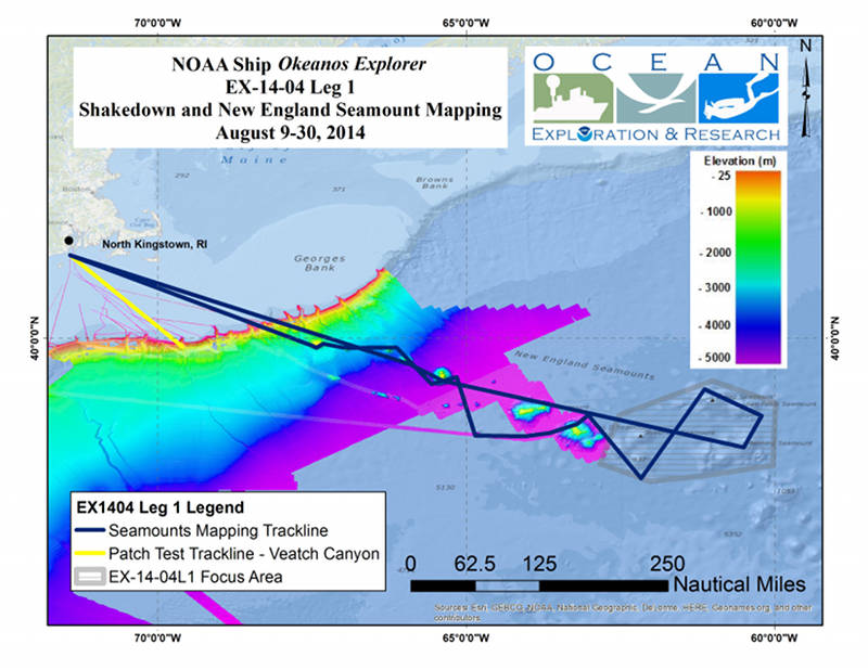
Map showing the area where the Okeanos Explorer will conduct operations during the Shakedown and Mapping New England Seamounts expedition. Color-coded bathymetry previously collected by Okeanos Explorer and by the University of New Hampshire’s Center for Coastal and Ocean Mapping UNCLOS expeditions, shown in the background of the operating area for context. Map created with ESRI ArcMap software. Download larger version (jpg, 3.0 MB).
From August 9-August 30, 2014, NOAA Ship Okeanos Explorer will conduct a 22-day expedition in the North Atlantic in Veatch Canyon and along the New England Seamount chain.
The first several days of the expedition will be dedicated to testing and calibrating mission-critical mapping and communication systems that were upgraded during a recent in-port maintenance period. The rest of the expedition will be focused on exploring and mapping undersea mountains (“seamounts”) located east of Georges Banks within the New England Seamount chain that extends for approximately 1,100 kilometers off the continental shelf into the deep waters of the North Atlantic.
The expedition will begin and end at the ship’s home port of North Kingstown, Rhode Island.
Spread across the world’s oceans, seamounts encompass about 28.8 million square kilometers of the Earth's surface – an area larger than South America. That is an area larger than deserts, tundra, or any other single land-based global habitat (Bountiful Seamounts Report). Marine scientists estimate that there a minimum of 45,000 large seamounts on Earth, with many smaller seamounts as yet undiscovered. Only about 200 of these seamounts have been biologically sampled, and few of them have been mapped in high detail.
The New England Seamount chain is the longest in the North Atlantic Ocean and is comprised of more than 30 submarine volcanic peaks that extend from east to west. These volcanoes were created by the movement of Earth’s crustal plates across a relatively stationary “hot spot” plume of magma in the Earth’s mantle. The formation of this chain of volcanoes is similar to how the Hawaiian Islands chain was formed in the Pacific Ocean.
Within the New England Seamount chain, the youngest and easternmost seamount (Nashville) formed approximately 83 million years ago and the oldest and westernmost seamount (Bear) formed approximately 100 million years ago. A detailed description of the geology of the New England Seamount Chain is available online.
The New England Seamounts are “islands” of hard rock substrate on an otherwise sediment-covered and relatively flat deep ocean plain. They are exposed to upwelling as ocean currents move over and around them. Rising up to 4,000 meters from the surrounding seafloor, the seamounts provide a steep gradient of depths and oceanographic conditions suitable for supporting unique and isolated habitats for a wide variety of marine species. Of particular note is the abundance and diversity of deep-sea corals that live on the seamounts. A previously completed NOAA-funded research expedition to the seamounts chain (“Mountains in the Sea” cruise) documented 18 species of deep-sea fish, at least 20 octocoral species, 3 stony coral species, 7 species of sponges, 20 species of polychaete worms, 18 crustaceans, 11 molluscs, 8 species of brittle stars, 5 sea stars, 5 anemones, and several other invertebrates – which is almost certainly just scratching the surface of the biological diversity present within the seamount chain.
The New England Seamount chain has been of interest to marine scientists for a long time, but much of the initial mapping and sampling work was limited to the seamounts closer to shore and used mapping systems far less advanced than those now used by the Okeanos Explorer.
Over the past decade, much of the U.S. Atlantic continental shelf margin has been mapped with modern multibeam sonar systems by the University of New Hampshire’s Center for Coastal and Ocean Mapping as part of the U.S. Extended Continental Shelf Project. This effort comprehensively mapped the western portion of the New England Seamounts chain, out to the vicinity of Balanus Seamount. In 2013, the Okeanos Explorer completed an exploration expedition to comprehensively map additional seamounts eastward along the chain, including Asterias, Kiwi, Kelvin, and Atlantis II Seamounts. This expedition also discovered and mapped a previously unknown seamount now referred to as Discovery Seamount.
The August 2014 expedition will directly build on these completed mapping efforts by mapping and exploring the seamounts located east of the portion of the chain that is already well mapped. During transit mapping operations, the Okeanos Explorer will collect limited data over Bear, Physalia, Retriever, Picket, Balanus, Panulirus, and Atlantis II seamounts, to fill minor data gaps and improve map resolution in areas that will complement the previously completed multibeam sonar mapping work.
Gosnold, Sheldrake, Gregg, San Pablo, and Manning Seamounts will be the primary focus of survey mapping operations during the current expedition. The expedition will produce high-resolution maps of the seafloor and collect acoustic backscatter data information about the seabed and water column. This information will contribute to scientists' understanding of the distribution of habitats on the seamounts and will be invaluable for the planning of future exploration and research.
The data collected by the Okeanos Explorer during this exploration will improve our understanding of the unique geology and biology of the New England Seamount Chain. Further up-close exploration of select areas within the seamount chain will be conducted in September 2014 by the Okeanos Explorer’s deep-water remotely operated vehicles, Deep Discoverer and Seirios.
All mapping data collected during these expeditions will be available in NOAA’s public data archives within 60-90 days of the conclusion of the cruise and can be accessed via the NOAA Ocean Exploration Data Atlas.
During the cruise, you can receive updates about the progress of our exploration work and view live video streams showing the multibeam sonar mapping work in action by checking our website.