By Jasper Konter, University of Hawaii

Map showing satellite-derived bathymetry of the Pacific Ocean based on gravity (color showing depth; purple to red is deep to shallow). The West Pacific has a larger number of seamounts than the rest of the ocean basin, and these are thought to be related to one of the hotspots (yellow stars) in French Polynesia. The arrows trace the volcanic chain back to currently active volcanism. Download larger version (jpg, 753 KB).
The West Pacific Ocean is underlain by some of the oldest seafloor in the world, and it hosts a large number of submarine volcanoes, referred to as seamounts. These seamounts are typically formed by small extents of melting in the Earth’s mantle, which may occur in several different geologic settings.
In one of those settings, the so-called hotspots, a chain of volcanoes forms as the Earth’s tectonic plates move over areas in the Earth’s mantle that are thought to be anomalously hot. In the hotspot model, material from deep inside the Earth moves to the bottom of the plate and melts due to its high temperature and decompression, and similarly to a flame burning a continuous hole through a passing piece of paper, the hotspot burns a chain of volcanoes into the tectonic plate. This means that the tracks of volcanoes can be used to study how the plates have moved back into Earth’s history compared to the mantle sources. For this type of work, the Hawaii chain of volcanoes, stretching all the way to the northwest Pacific through the Emperor Seamounts is the type-example.
However, the West Pacific is of particular interest due to its older age (providing a longer history than Hawaii) and the common occurrence of volcanic chains, including some far older than the oldest volcanoes related to Hawaii (providing a means to study plate motions further back in time).
Limited availability of samples from the many seamounts in the West Pacific suggest a general trend of oldest (~120 million years) in the northwest, and after a sharp bend in the chain near Wake Island around ~100 million years, progressively younger further and further to the southeast. Most of the seamounts in the West Pacific that are this age likely erupted in what is now French Polynesia, nearly 100 million years ago.

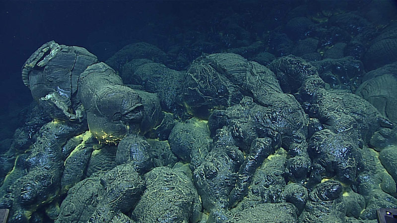
A pillow mound composed of glassy pillow lavas. Image courtesy of the NOAA Office of Ocean Exploration and Research, 2016 Deepwater Exploration of the Marianas. Download larger version (jpg, 1.2 MB).
Sparse sampling limits the precision of plate motion estimates at that time. Better age determinations and resulting plate motion models will be possible further back in time with more diverse samples, while the composition of the samples reveals the composition of the mantle sources (over time, along the chain). Besides actual ages, additional rough estimates of ages can be made based on seamount morphology and depth, since hotspot volcanoes usually follow a sequence through their lifetimes.
Submarine volcanoes start out as volcanic eruptions of basaltic rocks on the seafloor, building piles of what are known as pillow lavas (referring to their physical appearance), while lava flows are more rare. As the submarine volcano (seamount) grows near sea level, some eruptions may become explosive (from the mixing of magma with shallow water), depositing layers of volcaniclastic sediments (including hyaloclastites).
Once an island has formed, lava flows become more important in the volcano’s structure. After the volcano ceases to erupt, erosion breaks the island down in a matter of ~10 million years. At the same time, two types of covers develop: coral reefs near the surface and manganese crust at depth. Coral reefs usually develop on the flanks of these volcanoes in tropical areas, and as the volcano is eroded, the reef becomes more and more significant. As the last remnants of volcanic material are eroded by ocean waves, the reef remains near sea level, often forming ring-shaped islands known as atolls. Simultaneously, the plate underneath the chain of volcanoes is cooling down and slowly “sinking” into the mantle, which assists in the disappearance of the volcanic island, and eventually the drowning of the reef. Thus, the last stage in the volcanic chains is a drowned volcano covered with a reef structure that is flat-topped from the competition of reef building and wave action near sealevel. Such volcanoes are known as guyots, and they are a common occurrence in the West Pacific.

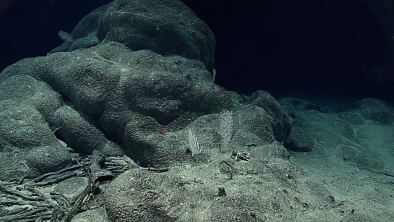
Ferromanganese crusts draping rocks (and even old sponge stalks) at Fryer Guyot in the Mariana region. Image courtesy of the NOAA Office of Ocean Exploration and Research, 2016 Deepwater Exploration of the Marianas. Download larger version (jpg, 1 MB).
The deep seamount cover, manganese crust, is a coating that is deposited on most old seamounts. Technically it is an iron-manganese (Fe-Mn) coating that precipitates from cold ocean water, which builds up at about one millimeter per million years. These crusts are rich in other metals as well and have long been considered to have potential as metal ores. In the West Pacific, the seamount surface can be covered in more than an inch of manganese crust, resulting in many underwater images showing black thickly coated surfaces that obscure the underlying materials.