NOAA Ship Okeanos Explorer
May 22 – July 2, 2018
 completed during both parts of the Windows to the Deep 2018 expedition. Map created by the NOAA Office of Ocean Exploration and Research. Service layer credits: Esri, DigitalGlobe, GeoEye, Earthstar Geographics, CNES/Airbus DS, USGS, AEX, Getmapping, Aerogrid, IGN, IGP, swisstopo, and the GIS User Community.")
Overview map showing seafloor bathymetry mapping coverage and ROV dives (white circles) completed during both parts of the Windows to the Deep 2018 expedition. Map created by the NOAA Office of Ocean Exploration and Research. Service layer credits: Esri, DigitalGlobe, GeoEye, Earthstar Geographics, CNES/Airbus DS, USGS, AEX, Getmapping, Aerogrid, IGN, IGP, swisstopo, and the GIS User Community. Download largest version (jpg, 448 KB).
Windows to the Deep 2018: Exploration of the Southeast U.S. Continental Margin was a two-part, 36-day telepresence-enabled expedition on NOAA Ship Okeanos Explorer to collect data on priority exploration areas identified by the ocean management and scientific communities. During the expedition, scientists explored a diversity of features with mapping and remotely operated vehicle (ROV) operations targeting deep-sea coral and sponge communities, maritime heritage sites, a landslide feature, and water column sonar anomalies of possible cold seeps.
Major accomplishments of this expedition are summarized below. For more information, download the summary fact sheet (pdf, 5.1 MB) or infographic (pdf, 1.4 MB).
Millions of people live along the U.S. East Coast, yet we know so very little about the deepwaters just offshore. During the Windows to the Deep 2018 expedition, we explored areas that had never been explored before, addressing the needs of the science and resource management communities, changing our expectations about what lies deep in the ocean off the coast, and helping the general public appreciate the beauty and wonder of what lies in our own deepwater backyard. Video courtesy of the NOAA Office of Ocean Exploration and Research, Windows to the Deep 2018. Download largest version (mp4, 81.9 MB).
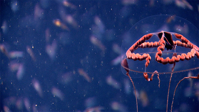
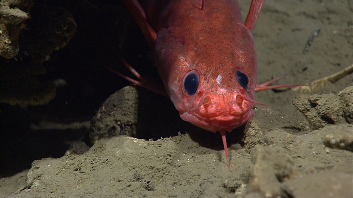
Throughout the expedition, scientists encountered coral and sponge communities in newly mapped areas, in previously unexplored areas, and in places they weren’t expecting to find such communities. Expedition ROV and mapping surveys, as well as previous Okeanos Explorer mapping in 2014, revealed one of the largest areas of deep-sea coral reef habitat ever discovered in U.S. waters, adding substantial evidence that previously mapped mounds of unknown origin are likely formed by the slow accumulation of Lophelia pertusa coral.
In fact, with the exception of one dive (which was on a suspected gas seep), deep-sea corals and sponges were observed, often at high to medium biological abundance and/or diversity, on every dive. Four of these dives were within marine protected areas (MPAs) managed by the South Atlantic Fishery Management Council, including the Stetson Miami Terrace Deep Coral Habitat Area of Particular Concern and the Cape Fear Lophelia Banks MPA.

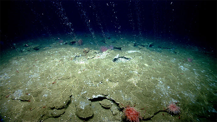
In addition to searching for coral and sponge communities, during the expedition, two dives targeted water column anomalies suspected to be cold seeps. On both of these dives, scientists saw evidence of methane seepage, such as this landscape view of the many bacterial mats seen along the seafloor during Dive 16 of the expedition. Image courtesy of the NOAA Office of Ocean Exploration and Research, Windows to the Deep 2018. Download largest version (jpg, 632 KB).
Not only do these discoveries change our expectations in terms of what lies in our own deepwater backyard, since we can’t manage and protect what we don’t know, all of these observations can help to inform management of these sensitive habitats and potential resources within the U.S. Exclusive Economic Zone.
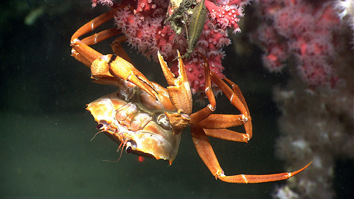
Through images shared by NOAA Ship Okeanos Explorer’s eye in the deep sea, the remotely operated vehicle Deep Discoverer, we have been treated to amazing insights into the lives and behaviors of a variety of deep-sea decapod crustaceans. Given the remoteness of their habitats, we very seldom have opportunities to see deep-sea organisms in their natural environment, so we know very little about their life history and behavior. On this particular day, we were provided a glimpse into the secret lives of two types of deep-sea crabs, Neolithodes sp. and Chaceon sp. Video courtesy of the NOAA Office of Ocean Exploration and Research, Windows to the Deep 2018. Download largest version (mp4, 53.4 MB).
During ROV dives, the team collected both biological and geological samples, adhering to the Okeanos sampling objective of acquiring the minimum number of samples needed to characterize a dive site. Of the animals collected, several are potential new species or were selected specifically to support trans-Atlantic connectivity studies. The team documented several fish and corals at greater depths and geographic ranges than ever observed before and also documented the presence of commercially important species, including red crabs, golden crabs, and wreckfish, in new areas. Additionally, the team observed several unusual predation events, including an Atlantic Midshipmen opportunistically grabbing a barracudina fish and a lithodid crab ripping a brittle star apart.
When combined with the observations of coral and sponge communities, these data will be important for increasing our ability to manage marine resources as well as increasing our understanding of deep-sea ecosystem connectivity across the Atlantic basin.
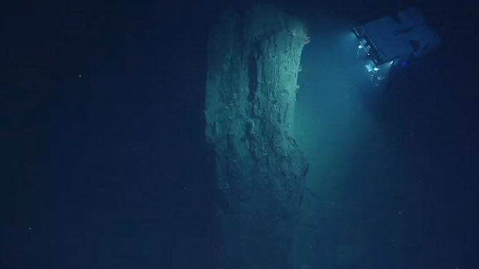
Over the course of the Windows to the Deep 2018 expedition, the Okeanos team mapped over 29,600 square kilometers, revealing several previously undetected features on our seafloor, such as intra-slope terraces and karstic features on the northern portion of the Blake Plateau, and unusually flat seafloor terrain relative to expectations from satellite altimetry data. Offshore Florida, Georgia, and South Carolina, numerous ridges and mounds, possibly of biological origin, were mapped; because of the size of these features, they were undetected from satellite data and only revealed in detail using the Okeanos Explorer’s high-resolution multibeam sonar.
 at Dive 04 on “Blake Escarpment South.” During the expedition, multibeam mapping revealed a series of terraced features (image B) and ROV exploration (at the site of the red mark) documented a highly diverse and dense community of deep-sea corals and sponges that were observed throughout the dive (image C).")
Prior to the Windows to the Deep 2018 expedition, this section of the Blake Escarpment appeared to be an area of low slope with no distinct features based on satellite altimetry. Image A shows satellite altimetry (Smith and Sandwell, 2014) at the Dive 04 site on “Blake Escarpment South.” During the expedition, multibeam mapping revealed a series of terraced features (Image B) and ROV exploration (at the site of the red mark) documented a highly diverse and dense community of deep-sea corals and sponges that were observed throughout the dive (Image C). Images courtesy of the NOAA Office of Ocean Exploration and Research, Windows to the Deep 2018. Download largest version (jpg, 1.6 MB).
During ROV dives, geological samples were collected that will help increase understanding of the geologic history of the region and to characterize habitat substrate.
Nearly every dive during the Windows to the Deep 2018 expedition took us to a place that no one had ever been before, allowing us to learn more about the different species that live in the region and how they are impacted by various environmental parameters. All of this information is crucial to managing resources in the deep ocean, as our management is only as good as our information. As humans, our reliance on resources from the deep ocean is only going to continue to grow, and with sound information such as that collected during Windows to the Deep 2018, we can develop plans to manage and use these resources in a sensible way. Video courtesy of the NOAA Office of Ocean Exploration and Research, Windows to the Deep 2018. Download largest version (mp4, 108.4 MB).
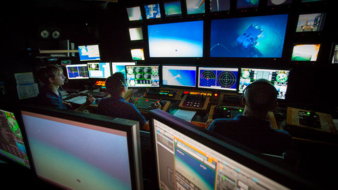
Data collected during this expedition are intended to inform initial characterization of the areas visited and includes multibeam, single beam, subbottom, ADCP, XBT, CTD and dissolved oxygen profiles; surface oceanographic and meteorological observations; video and imagery; and physical specimens. All data from this expedition will be publicly available through national archives and a direct link to expedition data will be posted on this website once available.

An octant discovered during an expedition dive on the Blake Ridge Wreck, which was originally discovered by a team from Duke University in 2015 and is likely an early 19th century wreck. Indicative artifacts imaged during the dive included an octant, bottles of wine, ceramic jugs, containers for food and other liquids, a small sewing kit with a pile of brass buttons, a slate, a vase, a tobacco pipe, and a comb. Data collected during the dive was used by the Bureau of Ocean Energy Management to develop 3D photogrammetry model of the wreck. Image courtesy of the NOAA Office of Ocean Exploration and Research, Windows to the Deep 2018. Download largest version (jpg, 2.3 MB).

Staff from Virginia Sea Grant, members of NOAA Atlantic Hydrographic Branch, and students tour NOAA Ship Okeanos Explorer at the conclusion of the expedition in Norfolk, Virginia. Image courtesy of Virginia Sea Grant, Lisa Sadler. Download largest version (jpg, 2.4 MB).
More than 140 scientists, resource managers, and students from 21 U.S. states and four international countries, including Russia, Portugal, Japan, and Norway, participated in the expedition – mostly from shore. This set a record for the number of science participants during any Okeanos expedition! Additionally, ship tours, ship-to-shore interactions, and live online streaming of ROV dives to the general public opened a window of understanding into the deep sea for audiences around the world.
Windows to the Deep 2018 was NOAA Ship Okeanos Explorer’s first expedition of the Atlantic Seafloor Partnership for Integrated Research and Exploration (ASPIRE) campaign, a major multi-year, multi-national collaborative field program focused on raising collective knowledge and understanding of the North Atlantic Ocean. Major expedition accomplishments are linked to ASPIRE goals in the summary fact sheet.