The Deep Connections 2018: Exploring Atlantic Canyons and Seamounts of the U.S. and Canada expedition on NOAA Ship Okeanos Explorer is cancelled.
by Kelley Elliott, Expedition Manager, NOAA Office of Ocean Exploration and Research
Dr. Martha Nizinski, Biology Science Lead, NOAA Fisheries National Systematics Laboratory
Dr. Jeffrey Obelcz, Geology Science Lead, Naval Research Laboratory
. The cruise will start August 10th from Norfolk, VA and end September 2, 2018 in Davisville, RI. Dives are planned from South Heyes Canyon offshore of Maryland, up to the Bonnecamps Canyon area offshore of Nova Scotia. The white lines are the boundaries of the U.S. and Canadian exclusive economic zone, and the green polygons are the Northeast Canyons and Seamounts Marine National Monument.")
Overview map showing the planned remotely operated vehicle dive sites for the expedition (white dots). The cruise will start August 10 from Norfolk, Virginia, and end September 2 in Davisville, Rhode Island. Dives are planned from South Heyes Canyon offshore of Maryland, up to the Bonnecamps Canyon area offshore of Nova Scotia. The white lines are the boundaries of the U.S. and Canadian Exclusive Economic Zones and the green polygons are the Northeast Canyons and Seamounts Marine National Monument. Image courtesy of the NOAA Office of Ocean Exploration and Research. Download image (jpg, 1.0 MB).
From August 10 through September 2, 2018, NOAA and partners will conduct a telepresence-enabled ocean exploration expedition on NOAA Ship Okeanos Explorer to collect critical baseline information of unknown and poorly understood deepwater areas of the Atlantic margin off the U.S. and Canadian east coasts. Like previous expeditions, NOAA will work with the scientific and resource management communities to characterize these areas through telepresence-based exploration. Operations will use the ship’s deepwater mapping systems and NOAA’s dual-body 6,000-meter remotely operated vehicle (ROV) Deep Discoverer (D2) and Seirios, as well as a high-bandwidth satellite connection for real-time ship-to-shore communications.
The ship will conduct 24-hour operations consisting of daytime ROV dives and overnight mapping operations. Exploration targets are expected to include undersea canyon and slope areas, seamounts, deep-sea coral and sponge habitats, chemosynthetic communities, and unmapped or poorly mapped areas. Data are expected to ground truth and inform deep-sea coral habitat suitability models and geohazards models and support science and management priorities of the U.S. and Canada. Information collected will enhance our understanding of poorly explored deepwater areas offshore of the U.S. Mid-Atlantic, New England, and Nova Scotia. Operations are planned to leverage and complement previous work in the area.
This is the third Okeanos Explorer expedition in 2018 that will contribute to NOAA’s Atlantic Seafloor Partnership for Integrated Research and Exploration (ASPIRE) campaign, a major multi-year, multi-national ocean exploration field program focused on raising collective knowledge and understanding of the North Atlantic Ocean. The campaign will provide data to inform and support research planning and management decisions in the region. ASPIRE builds on past U.S. exploration campaigns and international initiatives to support ecosystem-based management of marine resources across the North Atlantic. This cruise will also contribute to the ongoing collaborations with several NOAA offices, such as the National Marine Fisheries Deep-sea Coral Research and Technology Program.
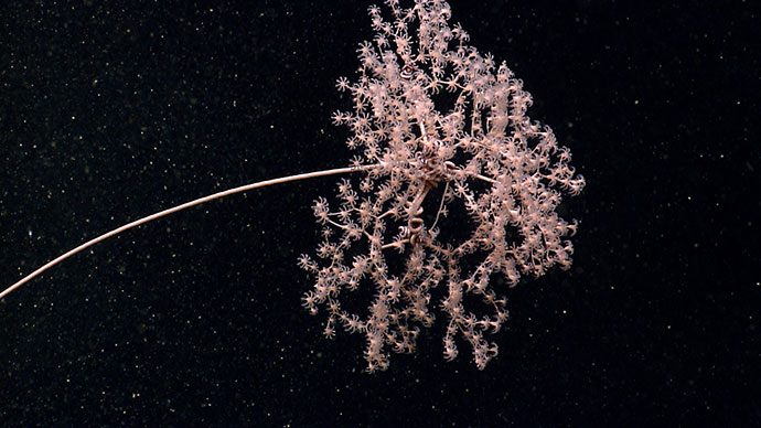
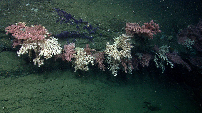
 and cup corals. Locating deep-sea coral and sponge communities, validating and improving predictive modelling capabilities, and increasing understanding of deep-sea ecosystem biogeographic patterns and connectivity across the Atlantic margin are all goals of the Deep Connections 2018 expedition.")
A rock face in Hydrographer Canyon hosts a diverse deep-sea coral habitat including octocorals (soft corals and sea fans) and cup corals. Locating deep-sea coral and sponge communities, validating and improving predictive modelling capabilities, and increasing understanding of deep-sea ecosystem biogeographic patterns and connectivity across the Atlantic margin are all goals of the Deep Connections 2018 expedition. Image courtesy of the NOAA Office of Ocean Exploration and Research. Download image (jpg, 1.4 MB).
Submarine canyons are prominent and important features along the Atlantic continental margin. They provide important connections between the shallow continental shelf and the deep sea by creating pathways for land-based sediments, organic matter, and unfortunately, marine debris. The focused water currents and steep walls of submarine canyons make them optimal habitat for deep-sea coral and sponge communities. The same steep walls that serve as settling substrate for deep-sea corals are also prone to landslides and can reveal extremely old rock layers (more than 100 million years before present) of interest to geologists.
Mapping and in situ data collected within submarine canyons and on the shelf edge between canyons is relatively sparse, making the deepwater data collected during expeditions like these important to scientists who study submarine canyons and managers responsible for resources within canyons. These data are also important for informing predictive models to better understand, for example, the spatial distribution of deep-sea corals and landslide-prone canyon walls.
Generally, canyons are biodiversity hotspots, harboring sensitive marine habitats (e.g., deep-sea coral and sponge communities and chemosynthetic habitats) and a variety of organisms, including commercially, recreationally, and ecologically important species. Thus, it is not surprising that canyons have become a priority for resource managers and scientists. Previous work suggests that canyons have their own biological and geological signature. But we can’t effectively manage and conserve what we don’t know. Filling in knowledge gaps provides us the opportunity to better understand species distributions, the processes influencing the structure of these sensitive deep-sea communities, and connectivity between canyons. We also know that organisms don’t stop at the border. By working across geopolitical boundaries, we will gain a better understanding of the western North Atlantic as a whole.
The Deep Connections 2018 expedition will address science themes and priority areas put forward by scientists and managers from the U.S. and Canada and international working groups supporting the Atlantic Ocean Research Alliance and the European Union’s Horizon 2020 program. NOAA priorities for the expedition include a combination of science, education, outreach, and open data objectives that will provide a better understanding of this important marine region.
Specific goals include:

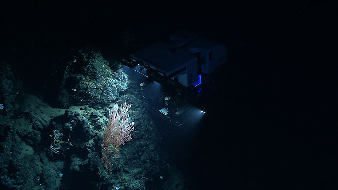
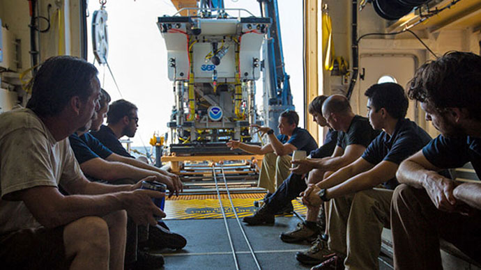
NOAA Ship Okeanos Explorer uses telepresence technology to transmit data in real time to a shore-based hub where the video is then transmitted to a number of Exploration Command Centers located around the country as well as to any Internet-enabled device. Access to the video combined with a suite of Internet-based collaboration tools allow scientists on shore to join the operation in real time and allows the general public to follow the expedition online. Image courtesy of the NOAA Office of Ocean Exploration and Research. Download image (jpg, 1.1 MB).
NOAA Ship Okeanos Explorer, the United States’ first and only federal vessel dedicated to exploration of our largely unknown ocean, conducts operations in a unique way, using telepresence to engage the majority of the science team on shore. Using telepresence, real-time video and other oceanographic data are transmitted through satellite and high-speed Internet pathways to scientists and stakeholders around the country.
Scientists access the live feed by standing watch in Exploration Command Centers (ECCs), tuning in to the high-definition video via Internet-2, or watching the live video on standard Internet from their home institutions. Shore-based scientists interact with the ship through a teleconference line and Internet collaboration tools. Using these communication tools, scientists and students can contribute expertise and help guide the at-sea operations in real time, extending the reach of ocean exploration to more scientists and students than could possibly be accommodated onboard.
Anyone with an Internet connection can follow along with the expedition as high-definition video of ROV dives streams live to shore from ROV Deep Discoverer daily from August 11 through September 1, 2018. The same technology that allows scientists around the world to participate in the expedition from land also enables interested members of the public to experience deep-sea exploration, the wonder of discovery, and the fascination of science in real time. Additionally, mission logs, daily updates, educational materials, and multimedia elements will be added to the Ocean Explorer website throughout the expedition.