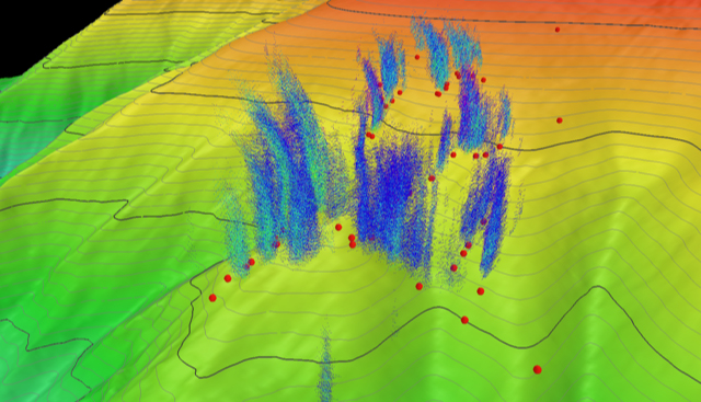
Seep Bathymetry
Upslope three-dimensional view of the Bodie Island seeps, with the upper slope bathymetry contoured at 10 meters (~39 feet). Bathymetry is shown with vertical exaggeration. Blue and green clouds in the water column were imaged by the Okeanos Explorer’s multibeam sonar and represent acoustic returns from ascending bubbles associated with methane plumes generated at seafloor gas seeps. The red circles on the seafloor are seep locations identified from previous water column imaging. Note that not every previously identified seep was associated with a methane plume during the current Okeanos Explorer expedition.
. Bathymetry is shown with vertical exaggeration. Blue and green clouds in the water column were imaged by the Okeanos Explorer’s multibeam sonar and represent acoustic returns from ascending bubbles associated with methane plumes generated at seafloor gas seeps. The red circles on the seafloor are seep locations identified from previous water column imaging. Note that not every previously identified seep was associated with a methane plume during the current Okeanos Explorer expedition.")