NOAA Ocean Exploration Announces FY23 Ocean Exploration Funding Opportunity Awards
NOAA Ocean Exploration selected nine projects for financial support through its Ocean Exploration Fiscal Year 2023 (FY23) Funding Opportunity. Totaling over $5 million, these projects will explore poorly understood U.S. waters off Alaska, Southern California, Puerto Rico, and the U.S. Virgin Islands; search for a historic shipwreck in the Olympic Coast National Marine Sanctuary off Washington; and develop tools and technologies to advance ocean exploration.
NOAA Ocean Exploration explores the ocean to help us as a society better understand what lives and lies in its great depths and how it supports and affects life on Earth. One of the tools we use to do this is an annual competitive grant program.
For the FY23 competition, we invited proposals for projects under the themes of ocean exploration and discovery, maritime heritage, and technology that support national priorities, including NOAA science and technology priorities and the Strategic Priorities for Ocean Exploration and Characterization of the United States Exclusive Economic Zone.
The supported projects are described below.
The Aleutian Arc: Integrated Exploration of Biodiversity at Priority Benthic Habitats*
Principal Investigator: Cheryl Morrison, U.S. Geological Survey
The Aleutian Arc is a volcanic arc that includes a chain of islands extending west from the Alaska Peninsula to international waters. The waters surrounding the Aleutian Islands are vast, and the biological and geological resources within them are ecologically and economically important. But, as of January 2023, only 34% of Alaska’s seafloor has been mapped, and even less has been explored. Much of the deep Aleutian Arc is virtually unknown. To advance our scientific knowledge about this region, where the potential for new discoveries is high, this research team will explore and provide initial characterization of high-priority sites in the central and western Aleutian Islands during a ship- and submersible-based expedition. Research targets for exploration and characterization include coral and sponge communities, volcanoes and other seafloor hazards, gas seeps, hydrothermal vents, and critical mineral deposits. Primary operations will include data collection (e.g., video and biological, geological, and water samples) during submersible dives and seafloor mapping. Results from this expedition will inform natural resource management, protection, and stewardship and hazard assessments, benefitting both Alaskan and national economies as well as human health and safety.
*NOAA Ocean Exploration is also supporting this expedition through the NOAA Ocean Exploration Cooperative Institute. Additional funding comes from the Bureau of Energy Management and NOAA Integrated Ocean and Coastal Mapping.
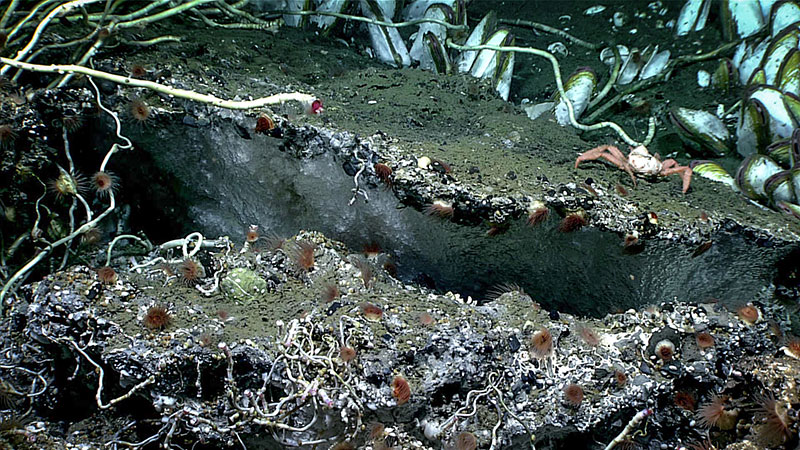
Exposed methane hydrate, a translucent white, smooth ice-like substance, attached to a carbonate overhang was seen at a depth of 2,018 meters (1.25 miles) during the fourth Seascape Alaska 3 expedition dive. The overhang was home to tubeworms, clams, anemones, and crabs. This was one of three areas where exposed hydrates were observed during the dive. Image courtesy of NOAA Ocean Exploration, Seascape Alaska. Download largest version (jpg, 1.88 MB).
Autonomous Deep-Ocean Exploration of Diverse Habitats Along the Aleutian Margin
Principal Investigator: Timothy Shank, Woods Hole Oceanographic Institution
The seafloor of the Aleutian margin hosts exotic ecosystems, including methane seeps and deepwater corals, and may also hold critical minerals. Given the importance of these natural resources, the U.S. government identified the U.S. Exclusive Economic Zone around Alaska’s Aleutian Islands as a priority for exploration and characterization. Little is known about the diverse ecosystems in these waters, so the potential for scientific discoveries is high, and the need for science to support knowledge-based policies is pressing. To further our understanding of this important region, this team will use cutting-edge tools and approaches, including two autonomous underwater vehicles with imaging and sampling capabilities (including a newly developed deep-sea methane sensor) to geologically, chemically, and biologically map the water column and seafloor along the eastern Aleutian margin. They anticipate discovering new seeps; chemosynthetic, coral, and sponge communities; seafloor minerals; and more. These findings will advance knowledge of the fundamental geological and biological features of the Aleutian margin, direct and inspire further exploration and research, and inform decision-making at the regional and national levels.
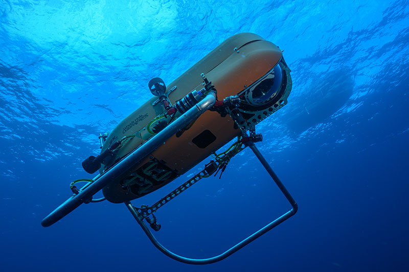
The autonomous underwater vehicle (AUV) Orpheus, the first in a new class of AUVs designed to withstand the pressure of the ocean’s greatest depths capable of working independently or as a networked fleet to explore, survey, and sample almost anywhere in the global ocean. Image courtesy of Marine Imaging Technologies, LLC, copyright Woods Hole Oceanographic Institution. Download largest version (jpg, 1.88 MB).
Autonomous, Directional Acoustic Profiling Float for Soundscape Characterization
Principal Investigator: Kaustubha Raghukumar, Integral Consulting Inc.
Sound is a crucial component of ocean science and stewardship. Deepwater soundscapes can provide insight into marine mammal distributions, seismic and volcanic activity, illegal fishing activity, other human activities, and more. Yet, collecting acoustic data in the deepest and most remote parts of our ocean has historically been difficult, largely due to the challenges of deploying and recovering traditional acoustic sensing equipment in these hard-to-reach places. To advance deepwater soundscape exploration, this research team will develop and demonstrate the first ever first autonomous, near-real-time, directional acoustic profiling float powered by marine renewable energy (ocean thermal energy conversion, OTEC). They will also develop soundscape analysis tools to provide insights into acoustic events of interest recorded by the float. The portable and low-cost float will enable sustained exploration of poorly understood deepwater soundscapes, eventually increasing the amount of global soundscape data — data that will expand the breadth of our deep-ocean knowledge, support biological and hazards monitoring, and inform management and mitigation of ocean noise to eliminate or reduce impacts on marine life.
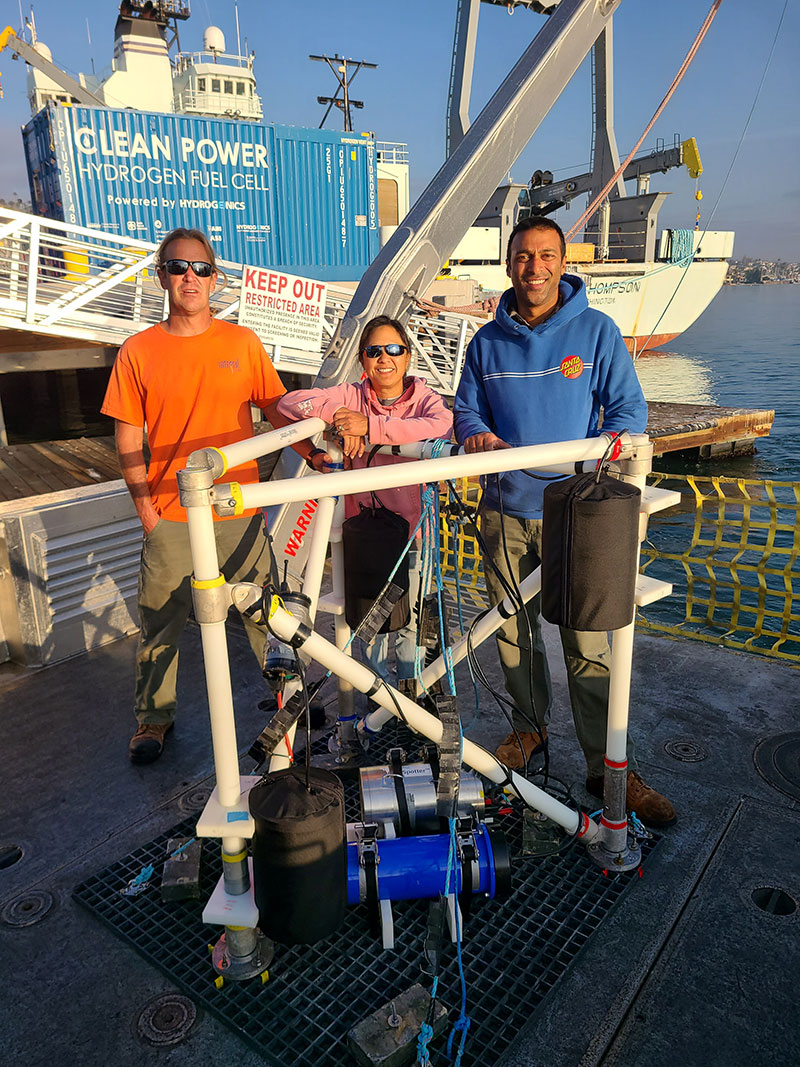
Integral Consulting team during field testing of the NoiseSpotter. Image courtesy of Garrett Staines (Pacific Northwest National Laboratory). Download largest version (jpg, 6.32 MB).
Autonomous Localization of Seafloor Fluid Flow Sources
Principal Investigator: Guangyu Xu, Applied Physics Laboratory, University of Washington
Some of Earth’s most unique habitats exist on the seafloor at sources of fluid discharge such as hydrothermal vents and cold seeps. The importance of these systems has been recognized for decades, and improvements have been made in the tools we use to search for them, such as autonomous underwater vehicles (AUVs). Nevertheless, the methods used for such exploration remain crude, and the reliance on human supervision hinders discovery. To streamline the process of locating seafloor fluid flow sites, this research team will develop a fully autonomous algorithm to enable AUVs to trace biogeochemistry signatures in the water column that are indicative of vents and seeps using real-time data recorded by onboard sensors, independent of human operators. After robust testing, they will demonstrate their approach at an active hydrothermal vent site off the Oregon/Washington coast. This new approach will improve the efficiency of AUV-based exploration and enhance the ability of scientists to conduct other operations at the same time while at sea. Ultimately, it has the potential to improve our knowledge about seafloor vents and seeps and the marine life they support.
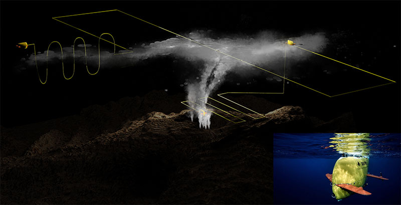
Schematic of autonomous plume tracing and source localization. Hydrothermal discharge rises above a submarine volcano then disperses laterally as a nonbuoyant plume. Yellow trace denotes a simplified autonomous underwater vehicle (AUV) survey that locates the depth of the nonbuoyant plume, maps its lateral extent, and autonomously implements a detailed deeper search that intercepts buoyant plume stems to locate vent sources. Inset: Sentry AUV. Image courtesy of Natalie Renier, Woods Hole Oceanographic Institution. Download largest version (png, 2.9 MB).
Deployable Artificial Intelligence for Exploration and Discovery in the Deep Sea
Principal Investigator: Kakani Katija (Young), MBARI (Monterey Bay Aquarium Research Institute)
We still have much to learn about our ocean and the animals that live within it. Modern robotics, low-cost observation platforms, and other emerging exploration tools are making underwater imaging easier and more accessible. However, processing all this visual data, particularly data with complex scenes and animals that require expert classifications, is quite resource intensive. This research team will use artificial intelligence (AI) to address this significant obstacle to discovery. Specifically, they will develop software for remotely operated and autonomous underwater vehicles to detect, track, and classify seafloor and water column animals in underwater video in real time. They will train this “deployable AI” using FathomNet, a publicly available underwater image training set, which they will expand and augment as part of this project, and test it in the waters of Monterey Bay National Marine Sanctuary. By automating the collection and real-time analysis of large volumes of underwater visual data by uncrewed underwater vehicles and making the imagery available in a global database, this project will enable scientists, policymakers, and the public to better, and more rapidly, understand the life that inhabits our ocean.
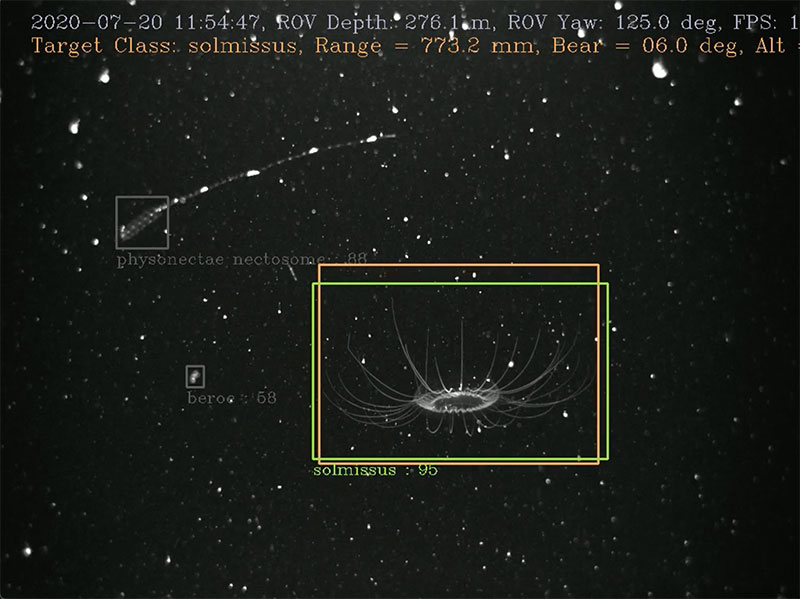
Demonstration of an artificial intelligence-assisted underwater robot during animal tracking trials. Image courtesy of MBARI's Bioinspiration Lab. Download largest version (png, 2.16 MB).
Diversity and Biopharmaceutical Assessments of Deep-Sea, Mineral-Rich Biomes off Southern California
Principal Investigator: Paul Jensen, Scripps Institution of Oceanography, University of California San Diego
Deep-ocean invertebrates and microbes hold undetermined biopharmaceutical potential that could drive innovations in biotechnology and advances for human health. Some of these organisms live on or around critical minerals that are increasingly important to modern society. To help us understand the tradeoffs associated with extraction of these minerals, this research team will assess the biodiversity and biopharmaceutical potential of benthic invertebrates and microbes at mineral-rich, deep-ocean sites within the Southern California Borderland (SCB). They will base their assessment on samples (sponges, soft corals, sediment cores, mineral rocks, and water) along with high-resolution video and still photographs collected from the SCB. Their work will establish biotic baselines for invertebrates and microbes in the SCB before any mineral extraction occurs, demonstrate the importance of biodiversity to biopharmaceutical potential, and encourage further academic and industrial biopharmaceutical research in the deep ocean. In addition, it will inform policy decisions regarding management of the SCB’s deep-ocean seafloor resources and mitigation of potential impacts and raise awareness of the potential value of deep-ocean habitats for human health.
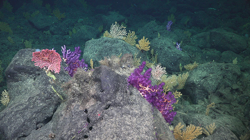
Deep-sea corals on San Juan Seamount off the coast of Southern California. Image courtesy of Schmidt Ocean Institute. Download largest version (jpg, 5.92 MB).
Early Encounters on a Western Frontier: The Search for Svyatoy Nikolai (1807-1808)
Principal Investigator: Katie Wrubel, Olympic Coast National Marine Sanctuary; Madeline Roth, NOAA Office of National Marine Sanctuaries (Cardinal Point Captains)
The Svyatoy Nikolai, a survey vessel for the Russian American Company, was lost at the turn of the 19th century in the waters of today's Olympic Coast National Marine Sanctuary (OCNMS). In 1808, the ship and crew (composed of men and women; Russian, English, and Aleut) departed Alaska to map the Pacific coastline and identify potential locations for an Oregon-based colony. The ship was driven ashore and abandoned off the coast of Washington. The stories of the crew and their subsequent interactions with Indigenous communities of the Hoh, Makah, Quinault, and Quileute tribes provide valuable insight into maritime history in the era of colonization. To better understand the region’s maritime heritage, this research team will search for the remains of Svyatoy Nikolai and other shipwrecks in OCNMS through remote sensing and targeted, noninvasive archaeological surveys. This project will result in baseline data to support monitoring and management of historic sites; develop and strengthen relationships among federal, state, and tribal heritage partners and other stakeholders; and enhance our understanding about the first interactions between Indigenous communities and settlers in the Pacific Northwest.
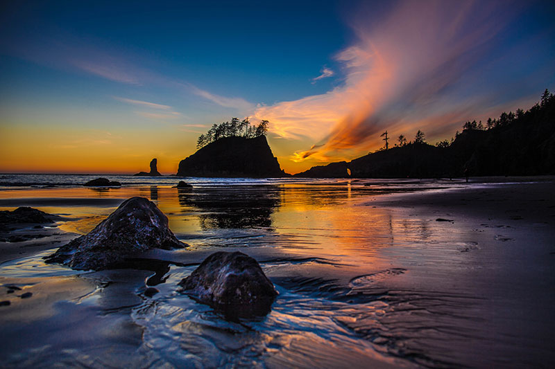
Reported loss location of Svyatoy Nikolai. Image courtesy of Matt McIntosh/NOAA Office of National Marine Sanctuaries. Download largest version (jpg, 5.58 MB).
Exploration of Deepwater Habitats off Puerto Rico and the U.S. Virgin Islands for Biotechnology Potential
Principal Investigator: Esther A. Guzman, Florida Atlantic University
Natural products produced by animals, plants, and microbes on land have long been used as sources of drugs and treatments for human illnesses and diseases. Marine natural products are also potential sources for such drugs and treatments. And now, they are having a growing impact in the field of biotechnology, and biopharmaceuticals in particular. While the potential of marine natural products may be great, access to them for preclinical and clinical investigations is not. This research team will explore and document marine habitats in deepwater areas around Puerto Rico and the U.S. Virgin Islands with the goal of collecting marine organisms (e.g., sponges, corals, and microorganisms) that may contain natural products that can be developed into useful pharmaceutical products. Collected samples and subsamples will be stored in and shared via a suite of long-term repositories that will enable future biopharmaceutical research and development. Knowledge gained during and as a result of this work will contribute to the treatment and prevention of existing and emerging illnesses and diseases.
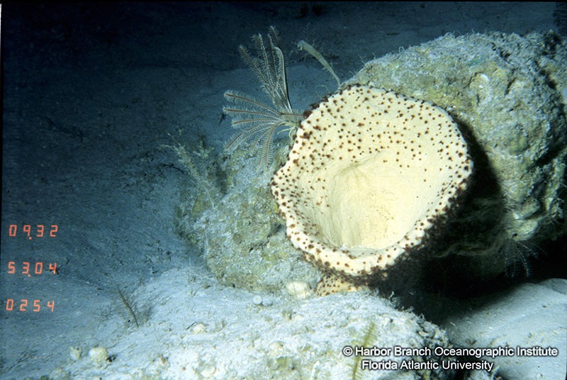
A marine sponge from a habitat off Puerto Rico. Image courtesy of Harbor Branch Oceanographic Institute, Florida Atlantic University. Download largest version (jpg, 472 KB).
Software Tools to Enable Automated Detection of Submerged Archaeological Sites From Multibeam Sonar
Principal Investigator: Katherine Skinner, University of Michigan
Recent advances in sensor technology and marine robotic systems have resulted in massive amounts of multibeam sonar data. However, finding submerged objects, like shipwrecks, within these data is time consuming and typically requires expert knowledge. This research team will address these challenges by developing a machine learning tool to automate detection and enable discovery of archaeological sites, limiting the need for human input. They will use existing data from Thunder Bay National Marine Sanctuary (TBNMS), deeper water data collected by NOAA Ocean Exploration on NOAA Ship Okeanos Explorer, and known shipwrecks to train and validate their tool. This tool will be integrated into an open-source, GIS-based toolkit. This project will reduce the time and cost required to detect archaeological sites from multibeam sonar data across the maritime heritage community — from the Great Lakes to the deep ocean — enabling discoveries to be made and shared with the scientific community and the public. TBNMS plans to use this tool to search for shipwrecks and other archaeological sites in the sanctuary, where more than 100 known wrecks have yet to be found.

Illustration of proposed system that takes input multibeam data and outputs a predicted segmentation mask that can be visualized as a GIS-compatible layer. Image courtesy of Katie Skinner and NOAA’s National Centers for Environmental Information. Download largest version (png, 76 KB).
Published August 1, 2023