


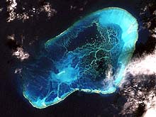
Satellite image of Pearl and Hermes Atoll, Northwestern Hawaiian Islands. Submerged banks and atolls will be mapped using multibeam sonar during the second leg of this expedition. Click image for larger view.
Northwestern Hawaiian Islands
September 18-23, and October 21 - November 15, 2002
About 70 percent of all coral reefs in U.S. waters are in the Northwestern Hawaiian Islands (NWHI), a remote chain of small islands and atolls that stretches for more than 1,000 nautical miles (nm) northwest of the main Hawaiian Islands. This fall, a team of scientists traveled there to study unexplored seamounts and map pristine coral reefs.
From September 18 to 23, scientists used the Pisces V submersible to dive on one of the region's unexplored Northampton Seamounts. These submarine features, which are over 60 nm long and reach within 180 ft of the ocean's surface, may be home to newly discovered species and a feeding stop for the Hawaiian monk seal. Between October 21 and November 15, scientists mapped submerged banks and seamounts in the NWHI Coral Reef Ecosystem Reserve. Multibeam sonar systems accomplished the mapping aboard the University of Hawai‘i's research vessel (R/V) Kilo Moana.
Follow explorers from the University of Hawai‘i's Undersea Research Laboratory and NOAA's Fisheries Service and Ocean Service as they venture to a part of the world that few have seen.
Background information for this exploration can be found on the left side of the page. Regular updates are included below. Detailed logs and summaries of exploration activities are found on the right.
Updates & Logs
Click images or links below for detailed mission logs.
 November 15 Before the era of electronic navigational aids, hydrographic surveys were conducted via lead line and sextants. With the advent of GPS and satellite imagery, scientists can use accurate data to create precise navigational charts.
  November 12 Finishing nearly a week ahead of schedule, the science team welcomes the opportunity to survey and collect more data around volcanic regions, banks, islets, and atolls.
 November 5 Halloween shrouded the scientists as they discovered seamounts, shelves, and sea stacks, while surveying the area around the Gardner Pinnacles, Laysan Island, and Lisianski Island.
 October 28 As the mapping team surveys the waters surrounding The French Frigate Shoals, they discuss the biological, ecological, and cultural roles the surrounding islands have.
 October 24 The mapping expedition has begun! During the mapping of Nihoa with multibeam sonars, several new discoveries were made.
 Summary Log A fisheries biologist recounts this expedition's fascinating finds, including a spongehead catshark, walls of gold coral, and fields of sponges.
 September 22 A bed of gold coral is found along a sheer vertical cliff. As the Pisces IV took a closer look, strong currents pinned the submersible against the cliff. Read a biologist's account of being trapped by the currents' grip.
  September 21 One fish, two fish, red fish, blue fish. A biologist discusses the differences between counting fish while SCUBA diving versus observing them from a submarine.
 September 20 Sightings of rare fish excite the science party, as the submersible dives continue around the Northampton Seamounts.
 September 19 The Pisces IV is launched, in driving rain, for the first manned submersible dive on the unexplored Northampton Seamounts.
 September 18 The exploration begins. Read about the mission and a perspective from one of the first divers.
 September 17 A member of the science team describes what they will be exploring on the seamounts of the Northwestern Hawaiian Islands.
Sign up for the Ocean Explorer E-mail Update List.