


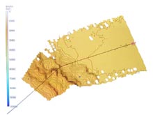
The Swan Surveyor depicting the R/V Atlantis (far right) mapping a section of the ocean floor. Click image for larger view.
Operation Orange: Expendable Bathy Thermograph (XBT) Deployment
August 4, 2004
Aurélie Shapiro
National Ocean Service
Special Projects Office
I woke up this morning at 3:21 am -- nine minutes before my alarm. The water lapping against the hull of the ship on the other side of my cabin wall sounded different than the night before. The R/V Atlantis was slowing down, preparing to Seabeam (echosound) the ocean floor to explore the topography of the seamount that was beneath us.
I stumbled into the lab to see computer screens flickering on every wall, displaying real-time latitude/longitude coordinates, sea surface temperature, wind, and boat speed. A high-pitched click -- an echosound ping, or sonar signal bouncing back from the sea floor -- sounded about every 10 seconds. On one monitor labeled Swan Surveyor, a little boat-shaped polygon moved slowly to the northeast with a 10 km swath of shaded relief in its wake, mapping the area that we’d just cruised over. (In 2002, researchers explored five seamounts on the central Gulf of Alaska Seamount Chain.)
“You better have some warm clothes,” said Dave Sims, the Atlantis SSSG (shipboard science support group). “You’re going to be launching the XBT.”
I’d heard tales of some apprehensive scientists covering their eyes and ears during their first expendable bathy thermograph (XBT) cast, because the device so closely resembles a grenade. The XBT sounds much scarier than it really is. It’s just a long black plastic tube that houses an eight-pound ball, attached to over 2,000 m of very thin copper wire.
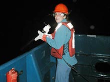
Aurélie Shapiro, color-coordinated even at 4 am, deploys the XTB. Click image for larger view.
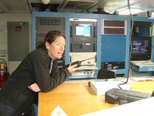
Rachel Teasdale at pre-dawn XBT data check. Click image for larger view.
I was equipped with safety goggles, thick bright-orange leather gloves, a bright-orange work vest, and a bright-orange hard hat (that I picked to match my outfit). Outside, the engine was quiet enough to hear the motion of the early morning Pacific. I held a big white gun, loaded with the XBT, over the ship’s aft deck -- well beyond the magic yellow line, where we’re usually not allowed to walk without steel-toed shoes.
Dave radioed to the bridge, inquiring about the speed.
“One-point-eight knots,” echoed from the radio.
“Speed up a bit, will ya?" Dave called back. "Let’s mosey along here . . . don’t want this wire getting caught on anything."
“Moseying, over.”
As the boat sped up, Dave pulled the grenade-like silver pin from the tube. Something plopped into the water, and the copper line started whizzing. “One-hundred meters . . . two-hundred meters . . . ” sounded the radio. It was the voice of Rachel Teasdale. She was inside the lab, reading off one of the lab computers as the XBT transmitted temperature data every quarter-second. It took at least five minutes for the readings to reach 1,800 m, and then I cut the copper line. (Hence, the "expendable" in XBT.)
Inside, Jason Chaytor was using the sound velocity profile to estimate depth by determining how fast the pings were moving through the water column. We wanted the ship to complete several passes over the seamount, overlapping on the peak, in order to make sure that areas of interest -- such as steep cliffs and rock faces -- weren’t in the center of a swath, as there is a data gap directly under the ship. We were pretty much dead on; the bubbling seamount unfolded on the screen before our eyes.
The clock ticked past 5:15 am, and we recognized a deep groove southwest of the seamount as the Tsimshian Sea Channel. By the time most everyone else on the ship was just waking up for breakfast, we had acquired enough data to make a 3-D map of the ocean floor!
Sign up for the Ocean Explorer E-mail Update List.