Celebrating 20 Years of NOAA Ocean Exploration
Deep-Ocean Mapping Highlights
The ocean impacts all of us — yet only about 20% of the global seafloor has been mapped with modern technology, and only a small percentage of the ocean has been explored. NOAA Ocean Exploration is the only federal program dedicated to exploring the ocean to fill gaps in our basic understanding of deep waters and the seafloor — and we’ve been doing it for 20 years.
The first step to building that understanding and unlocking the ocean’s potential is ocean mapping, which provides the framework for finer-scale exploration tools and techniques. Ocean mapping involves using acoustics, satellites, light and imaging, and other technologies to collect data about characteristics and resources of the ocean. NOAA Ocean Exploration mapping operations focus on the collection of seafloor, sub-bottom, and water column data for depths below 200 meters (656 feet), primarily using shipboard systems in addition to other platforms such as remotely operated or autonomous underwater vehicles.
Ocean mapping is critical to ensuring that we have the information, products, and services to prepare for and prosper in an ever-changing environment. So, as we round out 2021 and our celebration of 20 years of NOAA Ocean Exploration, here’s a look back at some of our mapping achievements from the past.
Looking Beyond: Extended Continental Shelf Mapping
In 2003, in partnership with NOAA's Office of Coast Survey and the University of New Hampshire, NOAA Ocean Exploration conducted the first expedition to map the U.S. Extended Continental Shelf (ECS) in the Arctic. This expedition set the stage for collaborative work across the federal government to determine the extent of our nation’s ECS, which is the portion of the continental shelf beyond the defined area that makes up a nation’s exclusive economic zone.
A formal task force that included NOAA and 13 other federal agencies, including the U.S. State Department, U.S. Geological Survey, and Bureau of Ocean Energy Management, was established in 2007 to manage the U.S. Extended Continental Shelf Project. NOAA Ocean Exploration was a critical partner in the project, leading or supporting multiple expeditions that contributed data to the mission of establishing the full extent of the continental shelf of the United States, consistent with international law. Through 2018, project partners worked together to gather and analyze field survey data, legal data, and seafloor samples to determine the United States' shelf outer limits, collecting over 3.3 million square kilometers (1.3 million square miles) of bathymetric data and over 27,000 linear kilometers (16,777 miles) of seismic data.
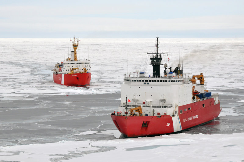
U.S. Coast Guard Cutter Healy (in the foreground) and Canadian Coast Guard Cutter Louis S. St. Laurent work together to map areas of the seafloor and to image underlying sediment layers in the Arctic. In 2010, the United States and Canada conducted a joint expedition in the Arctic to map and discover the full extent of the region’s extended continental shelf. This was the sixth in a series of U.S. expeditions to the Arctic Ocean and the third in which U.S. and Canadian scientists worked together on this mission. Image courtesy of USGS.
Learn moreRising Up: Multibeam Sonar Used to Detect Gas Seeps
In 2009, while testing a new multibeam sonar device on the recently commissioned NOAA Ship Okeanos Explorer, the NOAA Ocean Exploration team found something surprising: they began seeing readings that indicated a plume of something rising from the seafloor. That plume turned out to be a methane seep, and this marked the first time that multibeam sonar, which had been used only for seafloor mapping, was used to detect seeps of methane gas bubbling up from cracks in the seafloor. This was just the beginning. This finding led to new standards and protocols in the use of this tool for future seep detection that have benefited the broader ocean community.
In 2011 and 2012, we further refined the use of multibeam sonars for detecting gas seeps in the Gulf of Mexico. Subsequent mapping via Okeanos Explorer resulted in the discovery of nearly 600 previously unknown methane plumes along the edge of the Atlantic continental shelf.
We have and will continue to push the boundaries and applications of the science and technology needed to better explore not just the seafloor, but also the water column that lies above it.
Data from the multibeam sonar on NOAA Ship Okeanos Explorer provided a 3D image of an underwater gas plume rising 1,400 meters (4,600 feet) from the seafloor off the California coast in 2009. Video courtesy of NOAA Ocean Exploration.
Learn morePaving the Swath: Okeanos Explorer Gets an Upgraded Multibeam Sonar System
When NOAA Ship Okeanos Explorer was commissioned in 2008, the ship was equipped with an EM 302 deepwater multibeam sonar system — making it the first ship in the world to receive, what at the time, was cutting-edge mapping technology. After the ship’s commissioning, this multibeam system was operated nearly every day the ship was offshore. As with all technologies, however, systems get tired and advancements are made, and after many years of use, we decided it was time to give Okeanos Explorer’s multibeam system an upgrade.
Instead of swapping the multibeam system all at once, a phased replacement was undertaken in partnership with the NOAA Office of Marine and Aviation Operations and Kongsberg Maritime. The receive array was replaced in 2018. The topside transceiver unit was replaced with the EM 304 MK1 model in winter 2019/2020. And the transmit array was replaced during the winter dry dock of 2020/2021 to complete the upgrade to the EM 304 MKII multibeam sonar.
Once complete, Okeanos Explorer became the first ship in the world to receive this full upgrade. Successfully tested in Spring 2021 and then applied during expeditions for the remainder of 2021, the new mapping system significantly improves upon the performance of the EM 302, boosting depth range from a previous maximum of 8,000 meters (5 miles) to full ocean depth and increasing swath coverage. By enabling wider swaths of seafloor to be mapped, this upgrade of the ship’s multibeam sonar will increase the efficiency of NOAA Ocean Exploration’s mapping work.
As the only federal program dedicated to exploring the ocean, it is imperative for us to stay at the forefront of technology and standards, continuously paving the swath for others to follow.
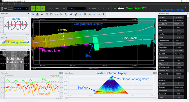
Screenshot of SIS5, the multibeam data acquisition software, while NOAA Ship Okeanos Explorer was underway and collecting data with the new multibeam system during the 2021 EM 304 Sea Acceptance Testing and Mapping Shakedown expedition. Image courtesy of NOAA Ocean Exploration.
Learn moreGoing Virtual: Telepresence and Cloud Mapping
Telepresence uses modern computer networks and a high-bandwidth satellite connection to enable remote users to participate virtually in ocean research and exploration expeditions. NOAA Ocean Exploration has been leveraging telepresence capabilities to guide exploration on NOAA Ship Okeanos Explorer since the ship was commissioned in 2008. In 2016, we began expanding the use of telepresence to mapping operations.
During “telepresence mapping” expeditions, some members of the expedition team work on shore to run mapping operations on the ship, process data, and even assist with troubleshooting issues with the sonar systems. This allows for expanded shore-based data processing of multiple sonar data streams, leading to enhanced, rapid initial site characterization and the broadening of multidisciplinary applications of ocean mapping expeditions.
Keeping with the virtual theme, in 2021, we piloted the processing of mapping data in the cloud, creating an environment where multiple experts can simultaneously work on data from anywhere in the world. In addition to broadening scientific capacity and advancing efforts to develop capabilities for ocean mapping by shore-based scientists, these technologies allowed us to host four interns who contributed to cloud-based mapping, furthering our outreach and education efforts.
The use of telepresence technology and cloud-based data processing also makes participation in ocean exploration more accessible for scientists, students, and members of the public who may have disabilities, health issues, or other commitments that would otherwise preclude them from participating.
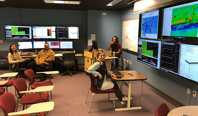
Image of the NOAA Ocean Exploration onshore mapping team at the University of New Hampshire Exploration Command Center participating through telepresence during the first part of the Windows to the Deep 2018 expedition. This image includes three of the explorers-in-training who participated in this expedition from shore. Image courtesy of NOAA Ocean Exploration.
Learn moreMajor Milestone: Two Million Square Kilometers of Seafloor Mapped
One million square kilometers. Sounds like a pretty big area, doesn’t it? But what’s even bigger? Two million square kilometers!
In early 2014, NOAA Ocean Exploration surpassed having mapped 1,000,000 square kilometers (386,102 square miles) of seafloor using the high-resolution multibeam sonar system on NOAA Ship Okeanos Explorer. On November 1, 2021, while conducting mapping operations on the Blake Plateau off the coast of the Southeast United States during the Windows to the Deep 2021 expedition, we reached the major milestone of 2,000,000 square kilometers (772,204 square miles) of seafloor mapped using Okeanos Explorer’s multibeam sonar system since the ship was commissioned in 2008.
Over the course of mapping this massive area of seafloor, Okeanos Explorer’s multibeam sonar has revealed numerous geologic features, including seamounts, trenches, ridges, wrecks, and banks that had previously been unknown or incorrectly characterized.
As excited as we are about having reached this milestone, we’re not stopping! Approximately 50% of the seafloor beneath U.S. waters remains to be mapped to modern standards, so there’s still a lot left to do. We’re up to the challenge of mapping all of our nation’s deepwater regions as we continue to evolve our operations on Okeanos Explorer and through our support for mapping efforts via other platforms.
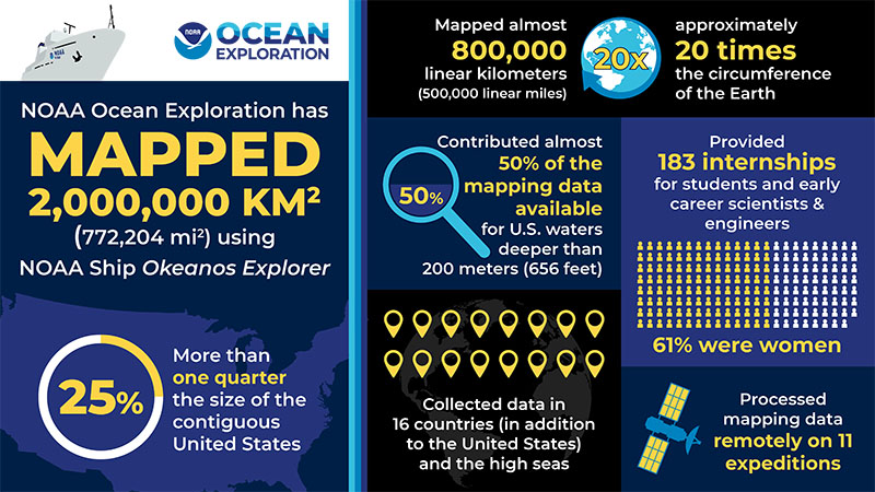
In November 2021, NOAA Ocean Exploration achieved the milestone of having mapped 2,000,000 square kilometers (772,204 square miles) of seafloor using the modern, high-resolution multibeam sonar system aboard NOAA Ship Okeanos Explorer since the ship was commissioned in 2008. Image courtesy of NOAA Ocean Exploration.
Learn more