


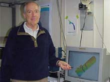
Dr. Peter Rona pointing to the latest results of the Hudson Canyon mapping, as seen on the SeaBeam viewer. Dr. Rona is the Principal Investigator (PI) for the cruise. In addition to being a professor at Rutgers University, Dr. Rona is considered the pioneer in the explorations of the deep ocean.
If you map it…They will come…
September 1, 2002
Lisa M. Weiss, Watershed Coordinator
Jacques Cousteau National Estuarine Research Reserve
“We know more about the backside of the moon than we do about the bottom of the ocean,” says Dr. Peter Rona, Professor of marine geology and geophysics at Rutgers University and chief scientist of our cruise Why is this true of a place that doesn’t even exist on our planet? According to Dr. Rona, it is because we can see the surface of the moon; we have front and back images and we have made detailed maps of the moon’s surface Mapping is the first step in exploration. So why then are only less than 5% of the world’s oceans mapped and explored in any detail?
One challenge is that the ocean’s floors are covered with about 2 miles of water. Therefore, the ocean bottom is not illuminated by sunlight like the surface of the moon. Light is absorbed too quickly into the oceans, allowing researchers to see only dimly with special underwater floodlights for about 50 yards, or half the length of a football field. This is best described as seeing the trunk of a tree, but not seeing the whole tree, and certainly not knowing that there is a whole forest there as well…using light, the seafloor can only be seen close up and the big picture remains hidden.
A common source of bioluminescence in the pelagic zone include fish, squid, shrimp and jellyfish. Click image for larger view.
Looking back at the history of oceanography, mapping of the seafloor was initially done using sounding lines. The first vessel dedicated to scientific exploration of the ocean, the British ship HMS Challenger, employed this method on a global voyage between 1872 and 1877. Sounding lines were generally made out of wire with a weight on the end that was lowered to the bottom of the ocean.. The length of the line that was reeled out was measured, and this length was recorded as the depth of the ocean. Because sounding lines could only be done point-by-point, seafloor mapping was painstaking and spotty.
Now, geological oceanographers, like Dr. Rona, use sound to help them map the physical features of the seafloor. Different from the way that it works in air, sound propagates very well in water. The mapping technique that uses sound is known as echo-sounding, and is accomplished by transmitting a pulse of sound (a high pitched ping) from an echo-sounder mounted on the hull of a ship. The ping hits the seafloor and bounces back to the ship, just like an echo. A recorder measures the time it takes for the sound to travel from the ship to the seafloor and back. The speed that sound travels along this path is known (~5,000 feet per second). Water depth is simply sound velocity multiplied by half the round-trip travel time of the pulse of sound from the ship to the seafloor and back. The recorder is calibrated to do this conversion from travel time to water depth and plots a profile of the depth and shape of the seafloor as the ship moves ahead. A limitation of the echo-sounding technique is that it only maps a narrow swath along the ship’s track. We are mapping a 60 X 100 mile stretch of the Hudson Canyon region in detail and it is going to take us about 2 weeks.
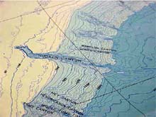
Another type of sea floor map made in 1968 by Heezan and Tharp. This map shows a rendition of the Hudson Canyon based on echo sounding. With this type of map, sea floor features appear more like 3-dimensional pictures, and are much easier to visualize than the contour line maps. Click image for larger view. .
The NOAA Ship Ron Brown has a state-of-the-art echo-sounding system that not only maps the depth and shape of the seafloor along the ship’s track, but simultaneously maps a swath of the seafloor with a total width to either side of the ship’s track up to several times the water depth. That means that we can map a swath about 5 miles wide in a water depth of 2 miles, but the swath becomes narrower as the water depth becomes shallower. If we were to map the whole ocean in detail comparable to our mapping of the Hudson Canyon area, it would take more than a century! Now you can understand why only about 5 percent of the global ocean floor has been mapped in detail.
The seafloor depth information collected with the echo-sounding technique can be represented on maps in two ways. One way is by showing depths with lines of contours. These lines connect all points that are at equal depth, forming what is known as a bathymetric contour map. The second way that the seafloor can be represented is by reconstructing 3-D images of seafloor features. In this fashion, submarine canyons like Hudson Canyon, submerged valleys and ocean ridges are not just represented by lines of equal depth, but appear as real features on the maps.
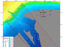
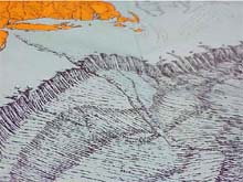
Image of tracklines and area being covered by the Hudson Canyon expedition. Each of the tracklines represent the path that the Ron Brown will follow as we continue with our swath bathymetric mapping of this 60 by 100 mile area. At our current pace of 10 knots, we are able to complete one trackline in roughly 6 hours. Click image for larger view.
Dr. Rona says he is thrilled to be exploring the Hudson Canyon because it is a true ocean wilderness right in the backyard of the largest metropolitan area on earth. But Dr. Rona is no stranger to ocean exploration. Dr. Rona has been the chief scientist on oceanographic expeditions to the most remote and inaccessible regions of all the oceans of the world. He has made many discoveries of the submerged volcanic mountain ranges that extend through the Pacific, Atlantic and Indian oceans. He led the exploration and discovery of the 1st hot springs, new life forms and giant mineral deposits in the Atlantic Ocean and the first black smoker hot springs offshore the United States. He has also dove to depths of several miles under the ocean with each of the 10 deep diving research submersibles operated by the US, France, Japan and Russia.
As Dr. Rona puts it, “Exploration of the Hudson Canyon really shows that we are in the earliest stage of exploring the ocean. The discoveries that we are making here close to home will pay off in terms of potential new resources, knowledge of undersea hazards, and understanding of climate change. The great age of ocean exploration is just beginning now with benefits to humankind.” We appreciate the support of the NOAA Office of Ocean Exploration and the opportunity to work with the NOAA Ship Ron Brown to carry out the exploration of Hudson Canyon..
Sign up for the Ocean Explorer E-mail Update List.