


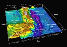
Figure 1. Bathymetry of the northeast corner of the Caribbean plate. Click image for larger view and image credit.
The Puerto Rico Trench: Implications for Plate Tectonics and Earthquake and Tsunami Hazards
Uri ten Brink, Chief Scientist
U.S. Geological Survey
The Puerto Rico Trench is the deepest part of the Atlantic Ocean, with water depths exceeding 8,400 meters (figure 1). Its depth is comparable to the deep trenches in the Pacific Ocean. Trenches in the Pacific are located in places where one tectonic plate subducts or slides under another one. The Puerto Rico Trench, in contrast, is located at a boundary between two plates that slide past each other with only a small component of subduction. The trench is less deep where the component of subduction is larger. The unusually deep sea floor is not limited to the trench, but also extends farther south toward Puerto Rico. The Puerto Rico Trench is also associated with the most negative gravity anomaly on earth, -380 milliGal, which indicates the presence of an active downward force. Finally, a thick limestone platform, which was originally deposited in flat layers near sea level, is now tilted northward at a uniform angle. Its northward edge is at a depth of 4,200 m, and its southern edge can be found on land in Puerto Rico at an elevation of a few hundred meters. Many tectonic models have been proposed to explain this geologically fascinating, tectonically active region; however, none have gained acceptance, and the region remains poorly understood, largely because its underwater location makes it difficult to study.
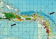
Figure 2. Location of earthquakes as a function of depth and size in the northeastern Caribbean. Click image for larger view and image credit.
Puerto Rico, the Virgin Islands to its east, and eastern Hispaniola to its west, are located on an active plate boundary zone between the North American plate and the northeast corner of the Caribbean plate (figure 1). The Caribbean plate is roughly rectangular, and it slides eastward at about 2 cm/yr relative to the North American plate. Motion along its northern boundary (in the plate boundary zone region) is dominantly strike-slip (a geological fault in which an adjacent surface moves horizontally), with a small component of shortening. In contrast, on its eastern boundary, the Caribbean overrides the North American plate, creating the island arc of the Lesser Antilles with its active volcanoes.
The geologic settings of Puerto Rico and the Virgin Islands have created or contributed to several pressing societal issues related to human safety, environmental health, and economic development. Over 4 million U.S. citizens live on these islands, mostly along the coast. Because the island lies on an active plate boundary, earthquakes are a constant threat, and the densely populated coastal areas are vulnerable to tsunamis. Erosion is a concern in many coastal areas, but is particularly serious to island economies that rely heavily on the tourist industry.
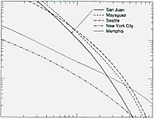
Figure 3. Probability for damaging ground motion at San Juan and Mayaguez in comparison to other seismic high-risk areas in the U.S. (e.g. Seattle). Click image for larger view and image credit.
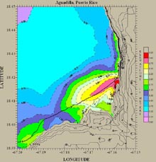
Figure 4. Numerical simulation of the 1918 Puerto Rico tsunami showing calculated inundation of the Aguadilla coast in northwest Puerto Rico. Click image for larger view and image credit.
The region has high seismicity and large earthquakes (figure 2). Examples include a magnitude 7.5 earthquake centered northwest of Puerto Rico in 1943, and magnitude 8.1 and 6.9 earthquakes north of Hispaniola in 1946 and 1953, respectively. Historically, other large earthquakes have also struck the area, such as one in 1787 (magnitude~8.1), possibly in the Puerto Rico Trench, and one in 1867 (magnitude~7.5) in the Anegada Trough (figure 1). A draft U.S. Geological Survey (USGS) hazard map places equal probability for damaging ground motion for Mayaguez in western Puerto Rico as for Seattle, Washington. Other Puerto Rican cities also have substantial risk.The hazard from tsunamis is also apparent. Immediately after the 1946 earthquake, a tsunami struck northeastern Hispaniola and moved inland for several kilometers. Some reports indicate that nearly 1,800 people drowned. A 1918 magnitude 7.5 earthquake resulted in a tsunami that killed at least 91 people in northwestern Puerto Rico (figure 4). Eyewitness reports of an 1867 Virgin Islands tsunami gave a maximum wave height of >7 m in Frederiksted, St. Croix, where a large naval vessel was left on top of a pier. Essentially, all of the known causes of tsunamis are present in the Caribbean -- earthquakes, submarine landslides, submarine volcanic eruptions, subaerial pyroclastic flows into the ocean, and major tsunamis called teletsunamis. Because of its high population density and extensive development near the coast, Puerto Rico has a significant risk for earthquakes and tsunamis.