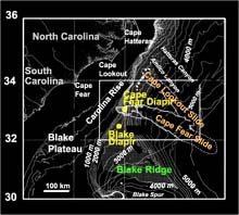
Dive sites for Windows to the Deep are the Cape Fear diapir, the Blake Ridge diapir, and the Blake Ridge depression. Click image for larger view.
Mission Plan - Windows to the Deep
Exploration of the Blake Ridge
Dr. Carolyn Ruppel, Co-Chief Scientist
Associate Professor
Georgia Institute of Technology
Background
The cold seeps on the Blake Ridge and Carolina Rise are located several hundred kilometers offshore of the Southeastern U.S. These seeps act as vents for methane that originates in the underlying gas hydrate deposits. Gas hydrates are essentially methane ice—a solid form of methane and water that is stable at the pressure and temperature conditions common in the marine sediments of continental margins.
Because these deposits concentrate large amounts of methane into a small volume, the U.S. and other countries consider them to be a possible future energy resource. Gas hydrates have also been implicated in the formation of submarine slides that not only destabilize large areas of the sea floor, but also produce tsunamis. As gas hydrates break down in response to pressure (sea level variations) or temperature disturbances caused by global climate change events, they may also release methane to the ocean and possibly even to the atmosphere. This could intensify global warming. The amount of methane trapped in sediments within the area that we will explore is estimated to be between 800,000 and 2,500,000 cubic meters per square kilometer.

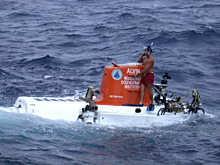
Alvin during recovery at the end of a day spent exploring the sea floor on the Blake Ridge. Click image for larger view.
Expedition Approach
In most of the study area, the top of the gas hydrate probably lies more than 100 meters below the sea floor. Under the geologic, thermal, and other conditions that prevail near cold seeps, seafloor chemosynthetic communities mark “windows” that provide unusual access to the top of the gas hydrate zone and methane venting system. At three such windows, this expedition will compile marine inventories, develop high resolution seafloor and shallow subseafloor maps, describe seep habitats, and contribute to a better understanding of gas hydrates. As we sail on the R/V Atlantis, we will conduct seven dives using the Alvin submersible. We will also use tools such as the Atlantis’s swath bathymetric system and a Chirp subbottom profiling system.

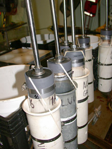
During the Windows to the Deep expedition, the scientists will extensively sample the seafloor sediments using push cores like these. Click image for larger view.
Site Descriptions
The three unique dive sites chosen for “Windows to the Deep” encompass the range of near-seafloor features considered critical for studying methane emission from the sea floor. At two of the dive sites, ancient, buoyant salt deposits (called diapirs) have risen through and pushed aside the surrounding sediments. Above these salt deposits, gas hydrate occurs very close to the sea floor. Fluid circulation in the shallow sediments carries methane, hydrogen sulfide, and other chemicals out of the sea floor. Near these, organisms such as clams, mussels, and tubeworms have established communities that rely on these flows.
At the third site, sediments have been deposited over a large area in a pattern that resembles a field of sand dunes. Previously collected seismic imaging has revealed a complex distribution of methane in the sediments beneath this area. “Windows to the Deep” will be the first mission to explore this type of feature for evidence of chemosynthetic (derives energy from chemical reactions) organisms or seafloor methane seeps.

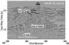
Single channel seismic data (line 23 of R/V Cape Hatteras cruise 95-18) collected by the US Geological Survey crossing the Blake Ridge Diapir from southwest (left) to northeast (right) provides an image of the subseafloor. The diapir is the pronounced concave feature in the middle of the diagram. Click image for larger view.
Expedition Objectives
During the mission, the scientists will conduct daily Alvin dives to:
• observe seafloor methane emission;
• retrieve clams, tubeworms, mussels, shrimp, and other organisms living at seep communities;
• sample bacterial mats that provide important information about the chemistry of fluids being emitted from the seafloor; and
• retrieve short sediment push cores using the Alvin manipulator arm.
Each night, the scientists will map the sea floor using a special system that measures water depth. We will use an acoustic pulse that penetrates the uppermost meters of the sediment column to look into them. By combining the biological and chemical information obtained from the Alvin samples and the geophysical data collected during the nighttime operations, scientists will develop a more complete picture of both the surface and subsurface manifestation of methane and other fluid seeps.


