


Deborah Glickson, Geologist and Ph.D Student. Image courtesy of NOAA.
Navigation
July 26, 2005
Deborah Glickson
Geologist
Ph.D Student
White towers emerge and disappear as the ROV lights land on them (Quicktime, 580 Kb)
It's several days into the expedition, and Dr. Gretchen Fruh-Green and I are watching Hercules explore the escarpment just west of the Lost City field. Our dive plan is to start at the top of the cliff and zig-zag up and down the slope, examining the carbonate cap, breccias, and deformed basement rock. All the while, we'll be moving east and then south toward the carbonate chimneys. Sounds simple enough, but how do the pilots know where Hercules is? And just as important, how do we?
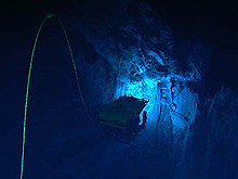
Hercules navigates among the huge white chimneys of Lost City. Many of the towers are only meters apart making it extremely important that the science team knows the ROV's exact location. Precise information is important for identifying the source of rock and water samples. Click image for larger view and image credit.
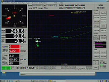
The DVLnav screen indicates the position of the NOAA ship Ronald H Brown and the IFE ROVs Argus, and Hercules. Heading and depth are shown on the left side of the screen, and X and Y coordinates are along the top. Click image for larger view and image credit.
Hercules navigates the seafloor by use of a Doppler velocity log (DVL). This instrument, mounted on the ROV, sends out a sound signal to the seafloor and measures the Doppler shift of its return. From this, the ROV's velocity is calculated and is used to determine position and depth. Accessing a program called DVLnav, Hercules pilots use the data to figure out where they are in relation to the ship, to Argus, and to the maze of tall, white spires in the field.
By contrast, for us at the science control center at the UW, the navigation is fairly simple. We get a live feed straight from the ship that tells us lots of important information, including things like the coordinates of Hercules and its depth. Using a program written by Jon Howland, a shipboard software engineer, we can continuously plot the position of Hercules and the ship on top of a map of the field. This means that we can see all of the places that Hercules has already visited on a dive and where it is right at the moment. With information that includes depth, altitude, and heading, we can precisely place ourselves on the side of a chimney and know what direction we're viewing. This stream of navigation data helps the scientists at UW plan where the vehicle should go next and relay that information to the pilots on the ship, thousands of miles away.
Most people are familiar with the geographic coordinate system, which uses latitude and longitude to determine the position of an object. Because so many of the important sampling sites at the Lost City field are only meters apart, we would need to plot latitude and longitude to the 5th or 6th decimal point to get a position, which just isn't convenient. Instead, we use a local cartesian coordinate system, where we pick an arbitrary point to be X=0, Y=0 and then navigate the field using these X,Y positions. We can always translate these positions back into latitude and longitude later, in case someone (like the ship's bridge) needs them.
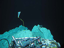
Marker 9: Markers are often used as a visual aid to navigation. This marker, 9, was placed near the IMAX flange during the 2003 cruise and is being used on this expedition to verify our position near the structure. Click image for larger view and image credit.
On the cruise in 2003, we identified some noteworthy sites - places of vigorous hydrothermal flow, interesting bacterial filaments, or particular beauty, for example. After placing a marker (a triangular piece of plastic on a string, weighted down with chain), the pilot would carefully mark the X and Y coordinates.Together, markers and coordinates allow the scientists and pilots of our expedition to easily return to important sites like the Nature Tower or the IMAX flange on Poseidon.
Well, I have to get back to X=5922, Y=10279 now.
Sign up for the Ocean Explorer E-mail Update List.