


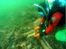
Ed Grossman holds a firebrick from the steamer CLARA NEVADA / HASSLER. Click image for larger view and image credit.
![]() Divers find the rear portion of the CLARA NEVADA's main shaft was unbolted and missing, giving testimony to a reported 1919 salvage effort which removed the propeller. This movie clip begins at the unbolted section as a diver swims forward over the engine and along the keelson. (Quicktime, 3.5 Mb.)
Divers find the rear portion of the CLARA NEVADA's main shaft was unbolted and missing, giving testimony to a reported 1919 salvage effort which removed the propeller. This movie clip begins at the unbolted section as a diver swims forward over the engine and along the keelson. (Quicktime, 3.5 Mb.)
Submerged Cultural Resource Management on the Last Frontier:
Reconnaissance, GIS Mapping, and Biotic/Geochemical Characterization of Threatened Shipwreck Sites in Southeast Alaska
April 4 – April 12, 2006
Dave McMahan, State Archaeologist
Office of History and Archaeology
Alaska Department of Natural Resources
Nearly half of the United States ocean coastline falls within the boundaries of the state of Alaska. Home for thousands of years to indigenous maritime Aleut, Eskimo, and coastal Indian cultures, Alaska and its people, past and present, have inextricable links with the sea. A longstanding source of food and clothing and, in historic times, a place of economic opportunity, Alaska’s coastal waters provide critical transportation links and function as conduits of social and cultural exchange. The state’s continental shelf is the final resting place for more than 4,000 known shipwrecks, many of which have historical or archaeological significance. In many instances, archaeologists believe that the cold North Pacific waters have contributed to an enhanced state of preservation. The wrecks are testimony to the unforgiving forces of nature: uncharted rocks, exposed headlands, crushing ice, and unpredicted or unheeded storms. High costs, vast distances, and seasonally cold violent weather have until recently precluded the systematic exploration and discovery of Alaska’s submerged cultural resources. In a sense, Alaska’s natural defenses protected and helped to preserve her sunken heritage. In recent years, however, the diffusion of new and inexpensive remote sensing and diving technologies have removed the barriers preventing exploration. Incidents involving the location and disturbance of protected submerged cultural resources have multiplied. The majority of these are located on or embedded in state submerged lands (i.e. between mean high tide and the three-mile limit). Archaeological and historical sites on state lands, including tidelands and submerged lands, are protected under state law. This allows for recreational diving on the wrecks, but not for unauthorized disturbance or collection. With a land mass of more than 586,000 square miles and pressing terrestrial cultural resources issues, the State of Alaska does not presently have the material resources nor in-house expertise to develop a marine archaeology program. As an alternative, the state is striving to build partnerships with federal agencies and academic institutions to begin generating the baseline data needed to manage and interpret its rich submerged cultural resources.
Documenting the Threatened Shipwrecks of Southeast Alaska
In April 2006, Alaska’s Office of History and Archaeology (OHA) collaborated with the University of Alaska Fairbanks (UAF), the University of Rhode Island (URI), the U.S. Minerals Management Service (MMS), and the NOAA National Marine Sanctuary Program to collect information on several historic shipwrecks in Southeast Alaska. These included the PRINCESS SOPHIA, S.S. ISLANDER, GRIFFSON, PRINCESS KATHLEEN, and CLARA NEVADA. Work was conducted off the U.S. Fish and Wildlife Service vessel CURLEW. During the project, the multi-agency dive team collected information on the condition of the shipwrecks, including digital photos and movie clips. Their information will be supplemented through interviews with recreational divers and historians familiar with the wrecks. These "snapshots in time" will allow future studies to better understand changes that are occurring due to natural and cultural processes. The divers placed small markers near the wrecks identifying their protected status, but collected no artifacts as part of the project. One aspect of the study, being undertaken by UAF, will focus on trace element analyses of surrounding sediments to better understand coldwater deterioration and effects of the wrecks on the marine environment. The UAF team also collected data on the marine biotic communities around the wreck sites and used a new multibeam high frequency sonar, DIDSON, to collect images of the Sophia and Kathleen from the surface.
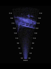
A high frequency (DIDSON) sonar image of the PRINCESS KATHLEEN. Note that the image is inverted. Click image for larger view and image credit.
Investigated Shipwrecks
The PRINCESS SOPHIA stranded on Vanderbilt Reef in October 1918 during a storm, eventually sliding into deep water and killing all of the estimated 350 persons aboard. The steamship, known as the “Titanic of the West Coast,” was loaded to capacity with folks heading south from Skagway for the winter. The passenger list included many the Yukon’s leading citizens, as well as numerous passengers from Victoria and Vancouver. Although a tremendous blow to the people of the Yukon, the wreck was overshadowed in the press by the end of the First World War. The wreck now rests on a slope in 80-150 feet of water. In April, the scientists focused efforts on imaging the wreck with high frequency (Didson) sonar rather than conducting dives.
The steamer ISLANDER and schooner barge GRIFFSON, whose histories are intertwined, are located in state tidelands south of Juneau. The ISLANDER sank in deep water after hitting an iceberg or uncharted rock in August 1901. Most of the 170 persons on board were lost. With reports of gold on board, talk of salvage began almost immediately, but the depth of the wreck exceeded the limits of contemporary diving equipment. It wasn’t until 1921 that the wreck was discovered in 300 feet of water. It was viewed from a diving bell in 1929, and in 1934 a monumental salvage attempt was undertaken by use of the GRIFFSON and another barge. By cradling the ISLANDER on cables run between the two barges and using extreme tide cycles for lifting, the vessel was moved to the beach. Not enough gold was found to pay for the massive salvage effort, and it is speculated that most of the gold was in the bow, which broke off during salvage. The wooden hull of the GRIFFSON was abandoned on the beach, where it remains today, along with remnants of the steel-hulled ISLANDER. The wrecks were documented by project scientists during a low tide cycle.
The PRINCESS KATHLEEN, a Canadian Pacific Railroad vessel built in 1925, went aground and sank northwest of Juneau in 1952 with no loss of life. The massive passenger liner now rests on a slope in around 80-140 feet of water. Due to close proximity to Juneau, it is a popular recreational dive site. The project dive team conducted a cursory examination of the wreck with scuba gear, but focused largely on obtaining images with high frequency (Didson) sonar due to poor visibility and strong currents.
The CLARA NEVADA, another Klondike gold rush era steamer, sank in 1898 off Eldred Rock as it was headed south down Lynn Canal from Skagway. Contemporary accounts of the sinking describe a bright orange fireball and burning ship near Eldred Rock. There were no reports of survivors. In later years, possibly due to speculation of Klondike gold on board, the event has become enshrouded in mystery. There have been suggestions of an illegal dynamite shipment on board, and rumors of survivors who escaped the wreck to begin new lives. The 150 foot vessel, originally powered by sail, was constructed in 1872 as a U.S. Coast and Geodetic Survey vessel. It was named for the agency’s first superintendent, Ferdinand Rudolph Hassler. The HASSLER initially served as a research vessel from which the famed naturalist Jean Louis Agassiz gathered deep sea samples in the Strait of Magellan. It later spent many years performing hydrographic survey and other government work in Alaska, where it became an important part of local culture. The HASSLER, decommissioned and purchased by the Pacific and Alaska Transportation Company, was on the return leg of its first voyage under the name CLARA NEVADA when lost.
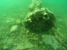
Early during the April documentation project, the team decided to focus its efforts on the CLARA NEVADA due to its shallow depth, accessibility, minimal disturbance, and unresolved questions. Scattered remnants of the historic vessel were located adjacent to rocky pinnacles just northwest of Eldred Rock, where a lighthouse now stands. The team documented frames and portions of the double-steel hull, as well as remains of the vessel’s engine, windless, and other meaningful architectural elements. The rear portion of the mainshaft was unbolted and missing, giving testimony to a reported 1919 salvage effort which removed the propeller. After several dives on the site, the scientists are only beginning to understand the site. They hope that additional investigation can eventually be undertaken to begin piecing together the CLARA NEVADA’s final story. In the meantime, they plan to compile information that will contribute to placement of the vessel on the National Register of Historic Places.
A beacon was placed on Vanderbilt Reef following the tragic wreck of the PRINCESS SOPHIA in which an estimated 350 persons died. Click image for larger view and image credit.
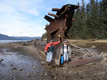
Stephan Jewett and Ed Grossman stand beside the sternpost of the salvaged ISLANDER. The GRIFFSON is visible in the background. Click image for larger view and image credit.
Public Outreach
In addition to scientific research, the project had a public component. Talks in Haines and Juneau addressed topics of recent OHA maritime collaborations, Alaska's coastal dynamics, the gold rush steamer PORTLAND, submerged resources at Pearl Harbor and the Pacific Islands, and the former Russian American Company steamer POLITKOFSY. An Alaska Magazine editor accompanied the scientists on one leg of the trip and plans to write about the findings.
Related Links
NOAA's Research website
– Featuring Southeast Alaska Historic Shipwrecks Project
Alaska Office of History and Archaeology
CanWest News Service
Shipwrecks Off Alaska’s Coast
Sign up for the Ocean Explorer E-mail Update List.