


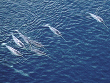
Several male narwhals in Inglefield Bredning, West Greenland, 2002. Click image for larger view and image credit.
Mission Plan
Dr. Kristin Laidre, Polar Science Center
Applied Physics Lab, University of Washington
Dr. Mads Peter Heide-Jørgensen
Greenland Institute of Natural Resources
From August 2006 to March 2007, scientists from the University of Washington and the Greenland Institute of Natural Resources will instrument 8-10 narwhals with satellite-linked time-depth-temperature recorders to track whale movements, diving behavior, and ocean temperature structure in Baffin Bay. The instruments will collect water column temperature profiles in the pack ice to >1,500 m depths when narwhals make a fall migration from north Greenland to their wintering grounds in Baffin Bay.
Baffin Bay is a large basin adjacent to the North American continent with a maximum depth of approximately 2,500 m. The bay extends northward from the Labrador Sea to the Smith Sound and is bordered on the west by Baffin Island and on the east by Greenland (approximately 66°N to 77°N and 54°W to 80°W). Baffin Bay has a broad, gently sloping shelf extending off the West Greenland coast to approximately 200 m, and a sharper, steeper shelf off the east coast of Baffin Island that drops into the deep basin in the center of the bay. Changes in the Baffin Bay ecosystem, with respect to water temperature, circulation, and sea ice, tie into both the climate of the North Atlantic and the changing global climate.
Narwhals are among the deepest diving cetaceans. Their deepest dives occur during winter in central Baffin Bay, where depths of over 1,500 m are regularly reached 10 to 25 times per day. These dives last over 25 minutes and are performed perpendicular to the bottom of the ocean to minimize the travel time needed to reach benthic prey. This behavioral feature makes the narwhal an excellent “ocean sampler”, as deep perpendicular dives are ideal for repetitive depth and temperature casts. Narwhals also have a strong affinity for the Arctic offshore pack ice, an area where few oceanographic studies have been accomplished due to inaccessibility, sea ice, and darkness. In this project the feasibility of using narwhals as oceanographic samplers for elucidating (and perhaps future monitoring) the spatial structure of the deep-water column in central Baffin Bay will be tested.
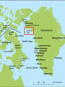
Map of West Greenland with Melville Bay shown in a red box. Click image for larger view and image credit.
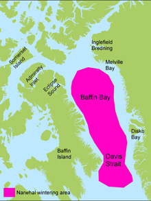
Narwhal wintering areas (pink) in Baffin Bay and Davis Strait. Click image for larger view and image credit.
The summer cruise will be conducted aboard the vessel m/v Sila a 7-person boat that often serves as a platform for coastal transportation and research in West Greenland. The study area encompasses the entire Melville Bay(76°N, 60°W), in North West Greenland. Traditional narwhal net capturing methods will be used. Nets are 50-100 m long and approximately 10 m deep. Nets will be set from shore or off the bow of the ship. Instruments (Wildlife Computers Mark 10-A) will be mounted on whales on the dorsal ridge with two 6 mm nylon pins. The transmitters are attached to the pins by 0.5-2 mm plastic coated wires secured and cut to restrict the movements of the tags. The handling procedure lasts approximately 30 minutes and is conducted with the whales held in the net between two inflatable boats. Data collected from diving narwhals will consist of point samples of time-depth- and temperature values at a resolution of 1 meter and 0.1°C. Geographic positions combined with these temperature data will be used to characterize spatial gradients in vertical water column structure based on date-time stamps, latitude and longitude, and horizontal area use.
In March 2007, field work in the Baffin Bay pack ice (71°N 60°W, 1,500 m depth) will focus on deploying sonic and satellite tags on narwhals from leads. These instrumentations will overlap with the time period tags deployed in summer stop transmitting to ensure complete coverage of the winter period. CTD (conductivity-temperature-depth) measurements (<200 m) will also be collected and used to calibrate data collected from instrumented narwhals. Pack ice work will be conducted from short-term mobile day camps, established on large (2-3 km or 5-6 mile wide) ice pans, stable in Baffin Bay until late in spring.