


Mariana Arc
Explore the volcanoes of the Submarine Ring of Fire 2006 expedition by clicking
on the thumbnails below to see a three-dimensional image or a ![]() virtual
fly-through of the Mariana arc.
Credits
virtual
fly-through of the Mariana arc.
Credits

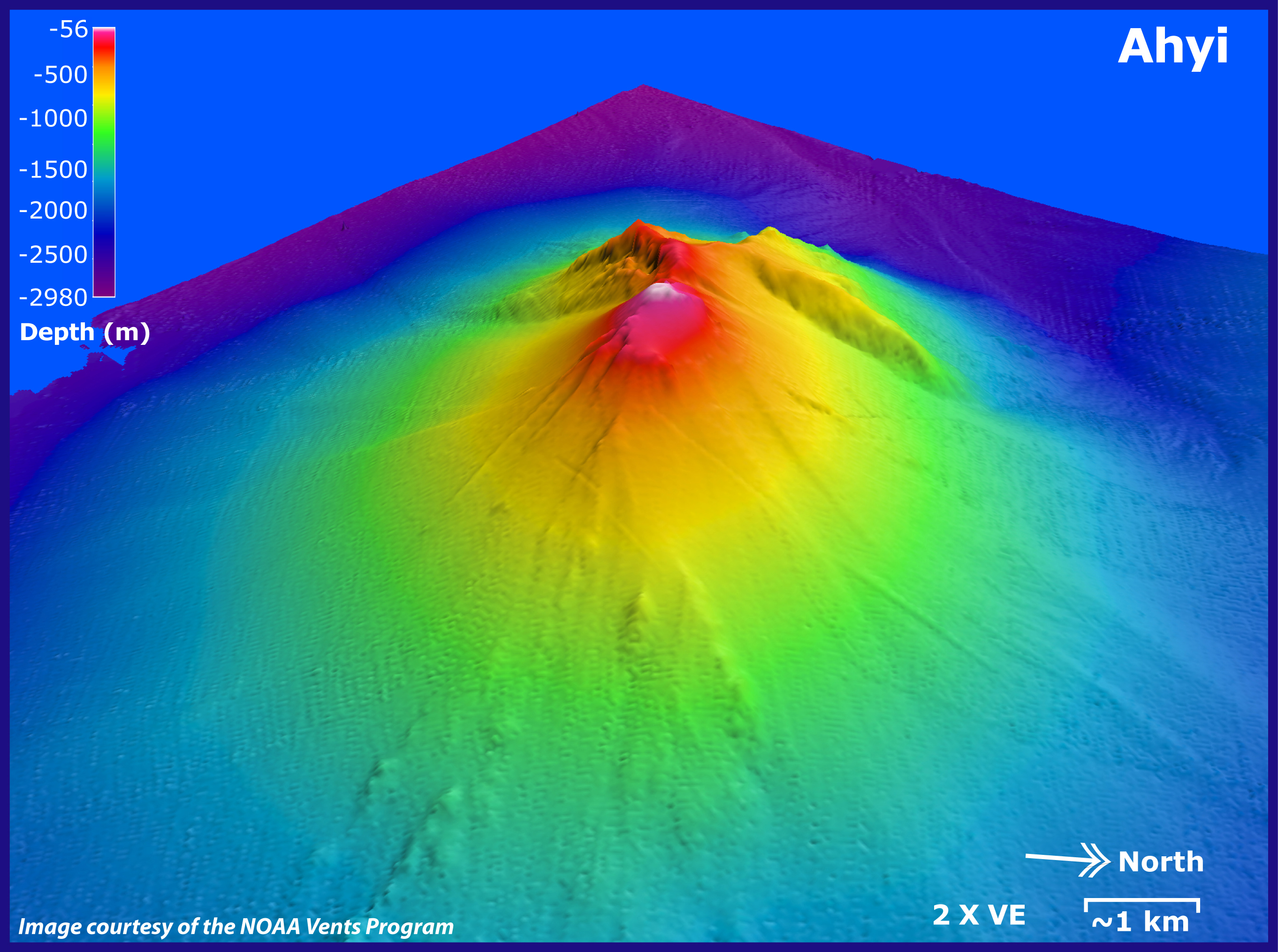
Ahyi submarine volcano, looking toward the southwest. Depths in this image range from 56 to 2,980 m (184 to 9,775 ft). Image is two times vertically exaggerated. EM300 bathymetry data resolution is about 25 m. Distance indicated is kilometers in foreground.
Download high-resolution image (jpg, 2.21 Mb)
![]() Virtual fly-through of the Ahyi submarine volcano. (Quicktime, 1 Mb.)
Virtual fly-through of the Ahyi submarine volcano. (Quicktime, 1 Mb.)

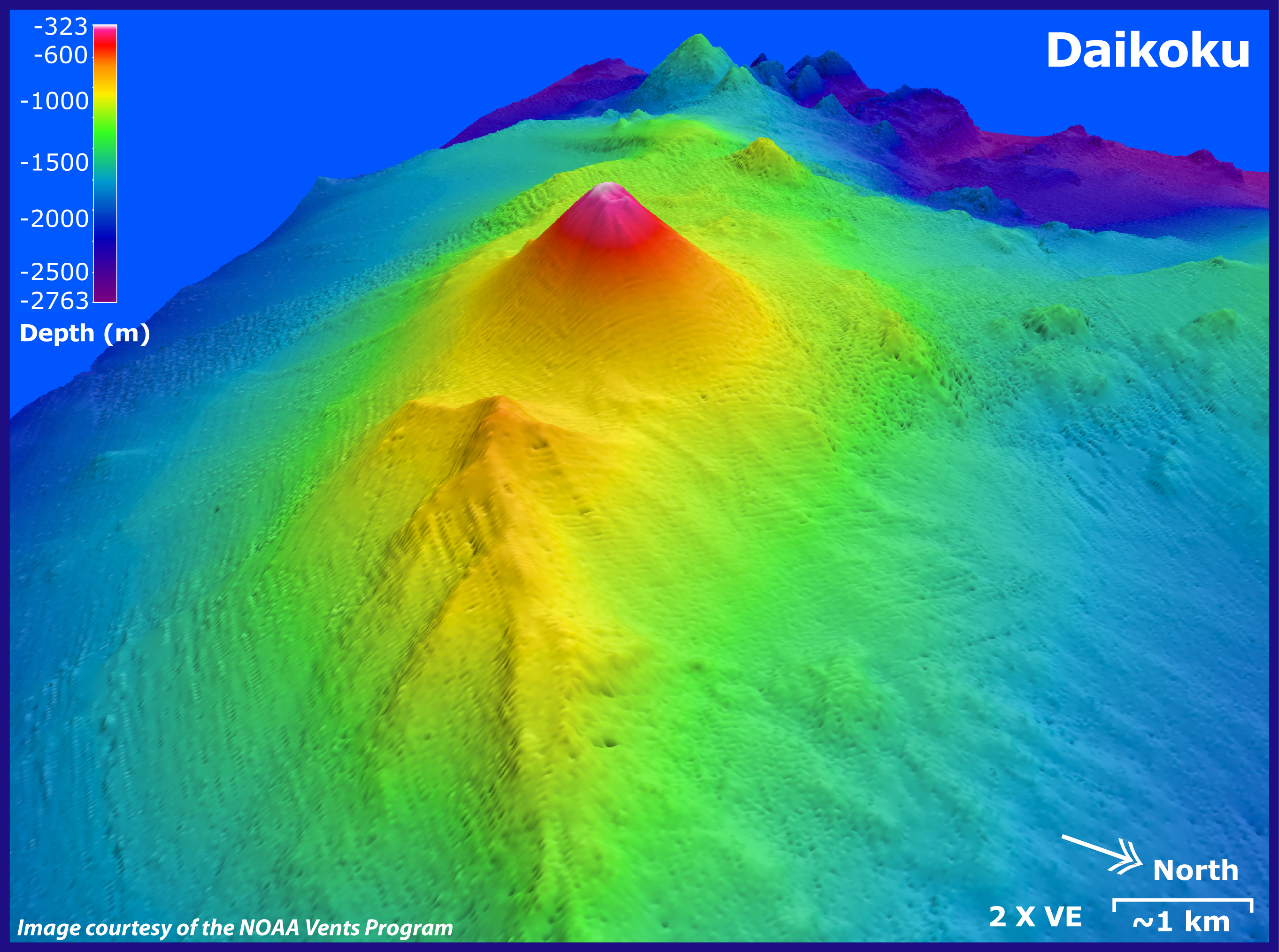
Daikoku submarine volcano, looking toward the west/southwest. Depths in this image range from 323 to 2,763 m (1,059 to 9,063 ft). Image is two times vertically exaggerated. EM300 bathymetry data resolution is about 25 m. Distance indicated is kilometers in foreground.
Download high-resolution image (jpg, 2.69 Mb)
![]() Virtual fly-through of the Daikoku submarine volcano. (Quicktime, 960 Kb.)
Virtual fly-through of the Daikoku submarine volcano. (Quicktime, 960 Kb.)

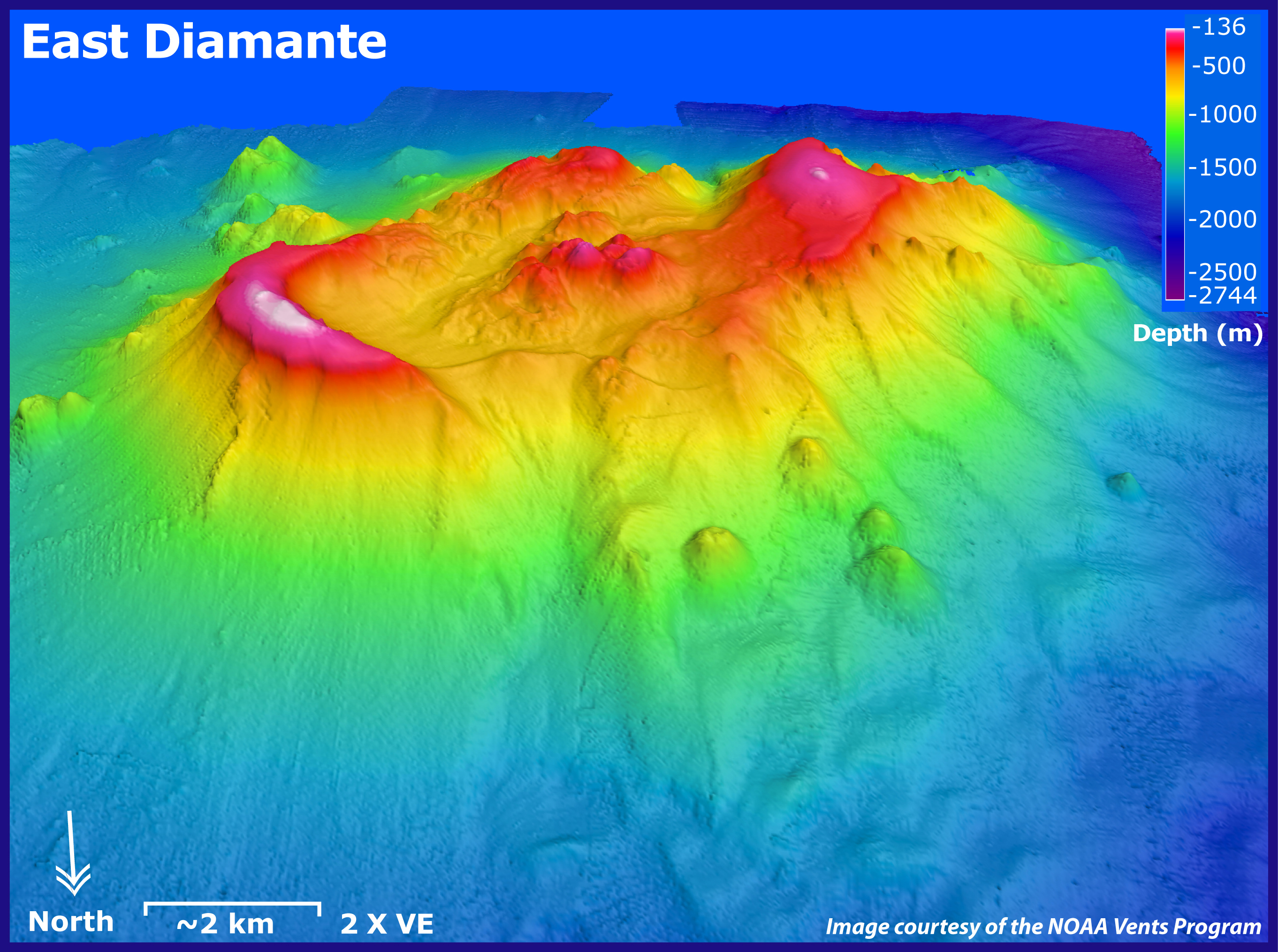
East Diamante submarine volcano, looking toward the south/southwest. Depths in this image range from 136 to 2,744 m (446 to 9,000 ft). Image is two times vertically exaggerated. EM300 bathymetry data resolution is about 25 m. Distance indicated is kilometers in foreground.
Download high-resolution image (jpg, 2.48 Mb)
![]() Virtual fly-through of the East Diamante submarine volcano. (Quicktime, 956 Kb.)
Virtual fly-through of the East Diamante submarine volcano. (Quicktime, 956 Kb.)

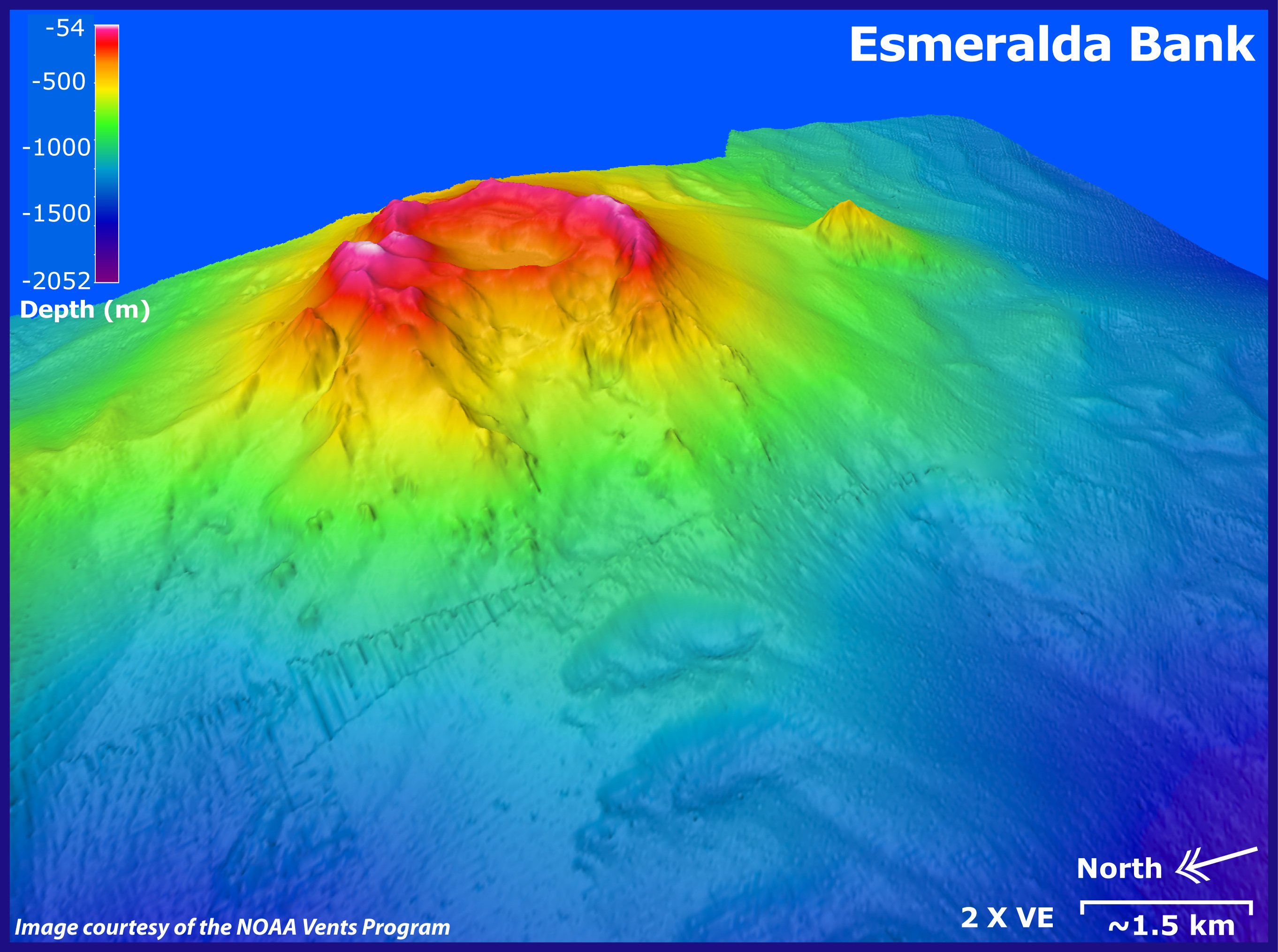
Esmeralda Bank submarine volcano, looking toward the southeast. Depths in this image range from 54 to 2,052 m (177 to 6,730 ft). Image is two times vertically exaggerated. EM300 bathymetry data (25 m resolution) overlaid on SeaBat data (50 m resolution). Distance indicated is kilometers in foreground. SeaBat data courtesy of Yoshihiko Tamura, JAMSTEC.
Download high-resolution image (jpg, 2.07 Mb)
![]() Virtual fly-through of the Esmeralda Bank submarine volcano. (Quicktime, 1.2 Mb.)
Virtual fly-through of the Esmeralda Bank submarine volcano. (Quicktime, 1.2 Mb.)

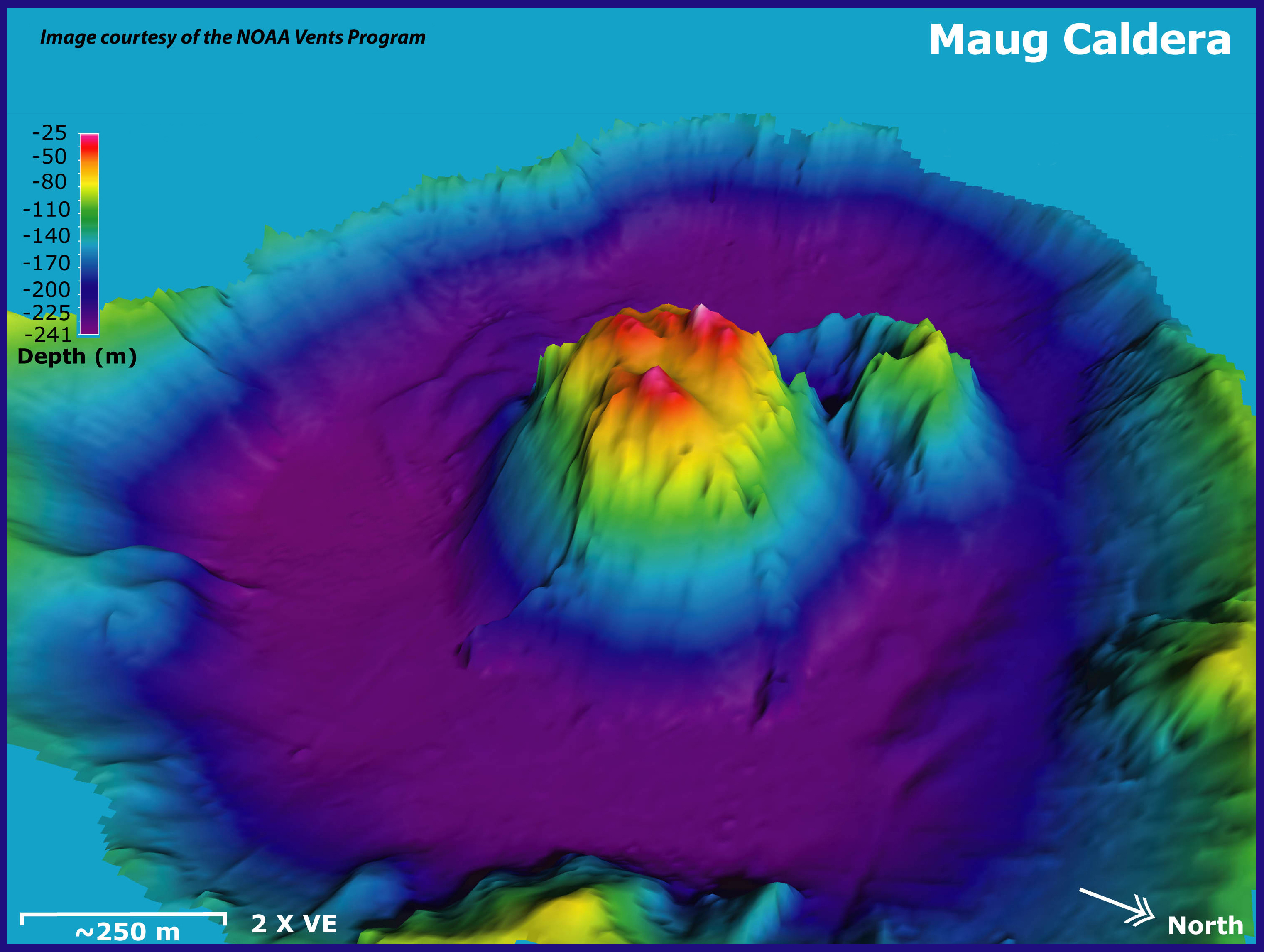
Maug submarine volcanic caldera, looking toward the west. Depths in this image range from 25 to 241 m (82 to 790 ft). Image is two times vertically exaggerated. EM300 bathymetry data resolution is 5 to 10 m at this water depth. Distance indicated is meters in foreground.
Download high-resolution image (jpg, 2.32 Mb)
![]() Virtual fly-through of the Maug submarine volcano. (Quicktime, 852 Kb.)
Virtual fly-through of the Maug submarine volcano. (Quicktime, 852 Kb.)

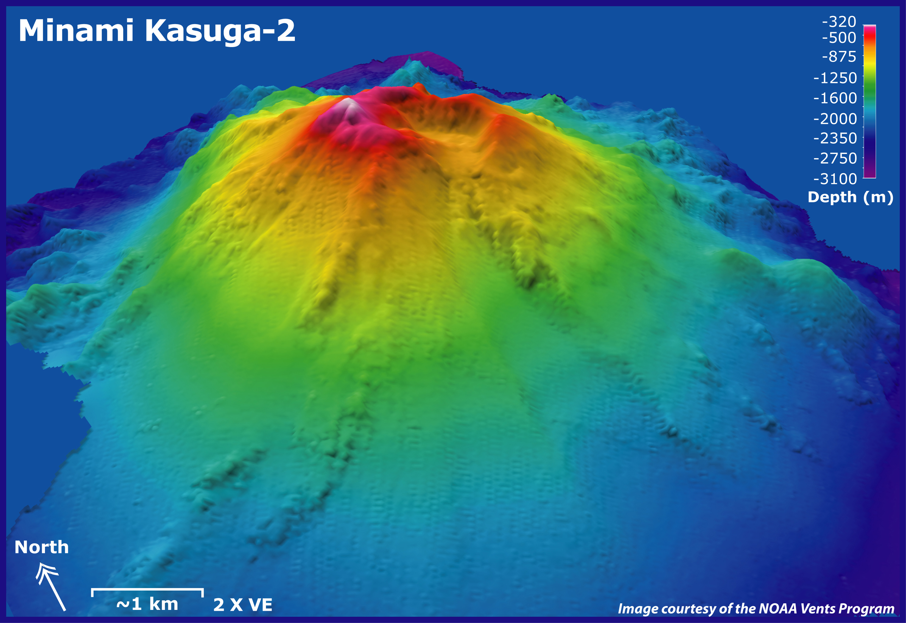
Minami Kasuga-2 submarine volcano, looking toward the northeast. Depths in this image range from 320 to 3,100 m (317 to 10,168 ft). Image is two times vertically exaggerated. EM300 bathymetry data (25 m resolution) are overlaid on SeaBat data (50 m resolution). Bathymetry data are two times vertically exaggerated. Distance indicated is kilometers in the foreground. SeaBat data are courtesy of Ko-ichi Nakamura, National Institute of Advanced Science and Technology, Japan.
Download high-resolution image (jpg, 2.08 Mb)
![]() Virtual fly-through of the Minami Kasuga-2 submarine volcano. (Quicktime, 1 Mb.)
Virtual fly-through of the Minami Kasuga-2 submarine volcano. (Quicktime, 1 Mb.)

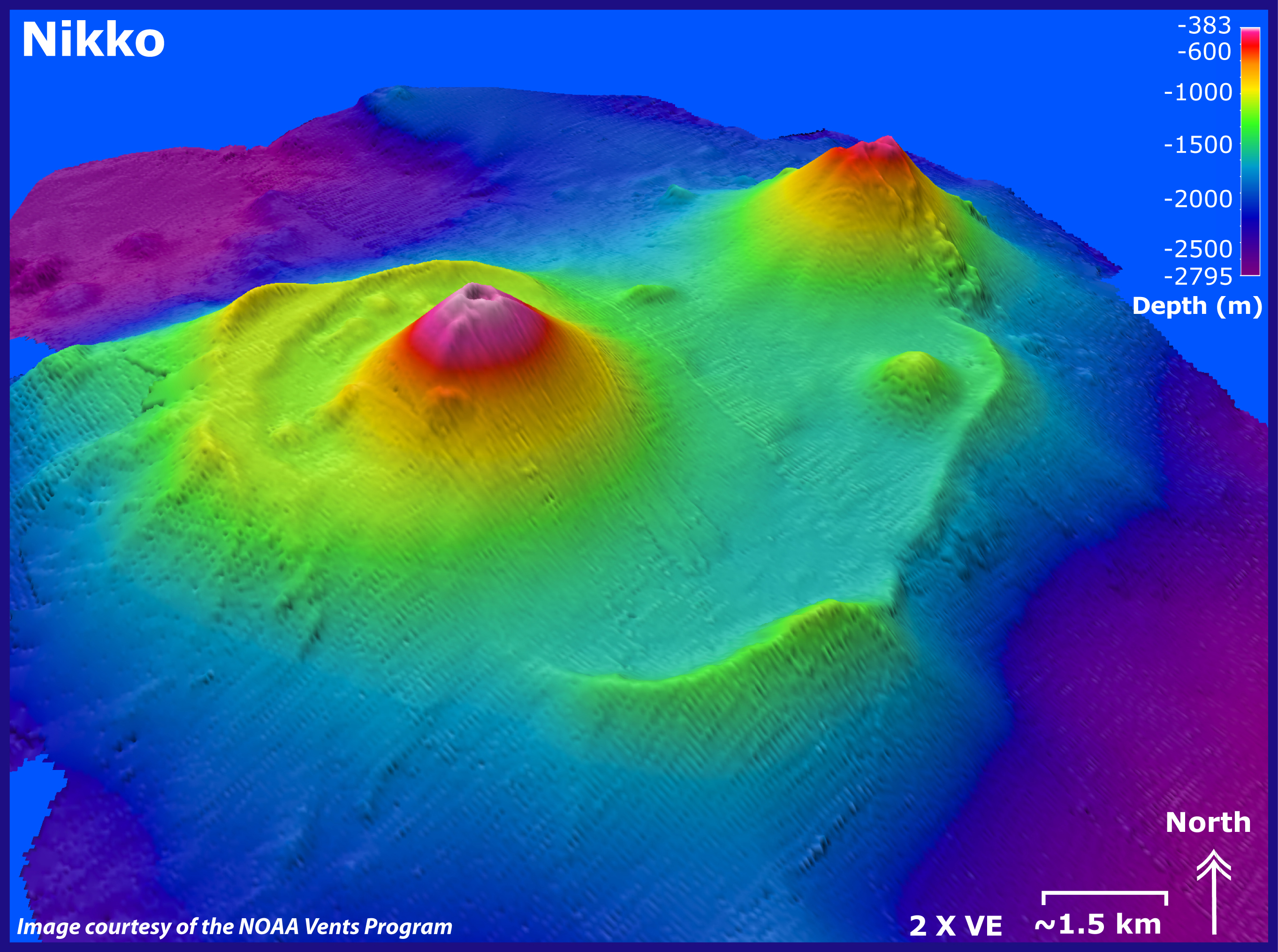
Nikko submarine volcano, looking toward the north. Depths in this image range from 383 to 2,705 m (1,256 to 8,872 ft). Image is two times vertically exaggerated. EM300 bathymetry data (25 m resolution) are overlaid on SeaBat data (50 m resolution). Bathymetry data are two times vertically exaggerated. Distance indicated is kilometers in the foreground. SeaBat data are courtesy of Ko-ichi Nakamura, National Institute of Advanced Science and Technology, Japan.
Download high-resolution image (jpg, 2.23 Mb)
![]() Virtual fly-through of the Nikko submarine volcano. (Quicktime, 1 Mb.)
Virtual fly-through of the Nikko submarine volcano. (Quicktime, 1 Mb.)

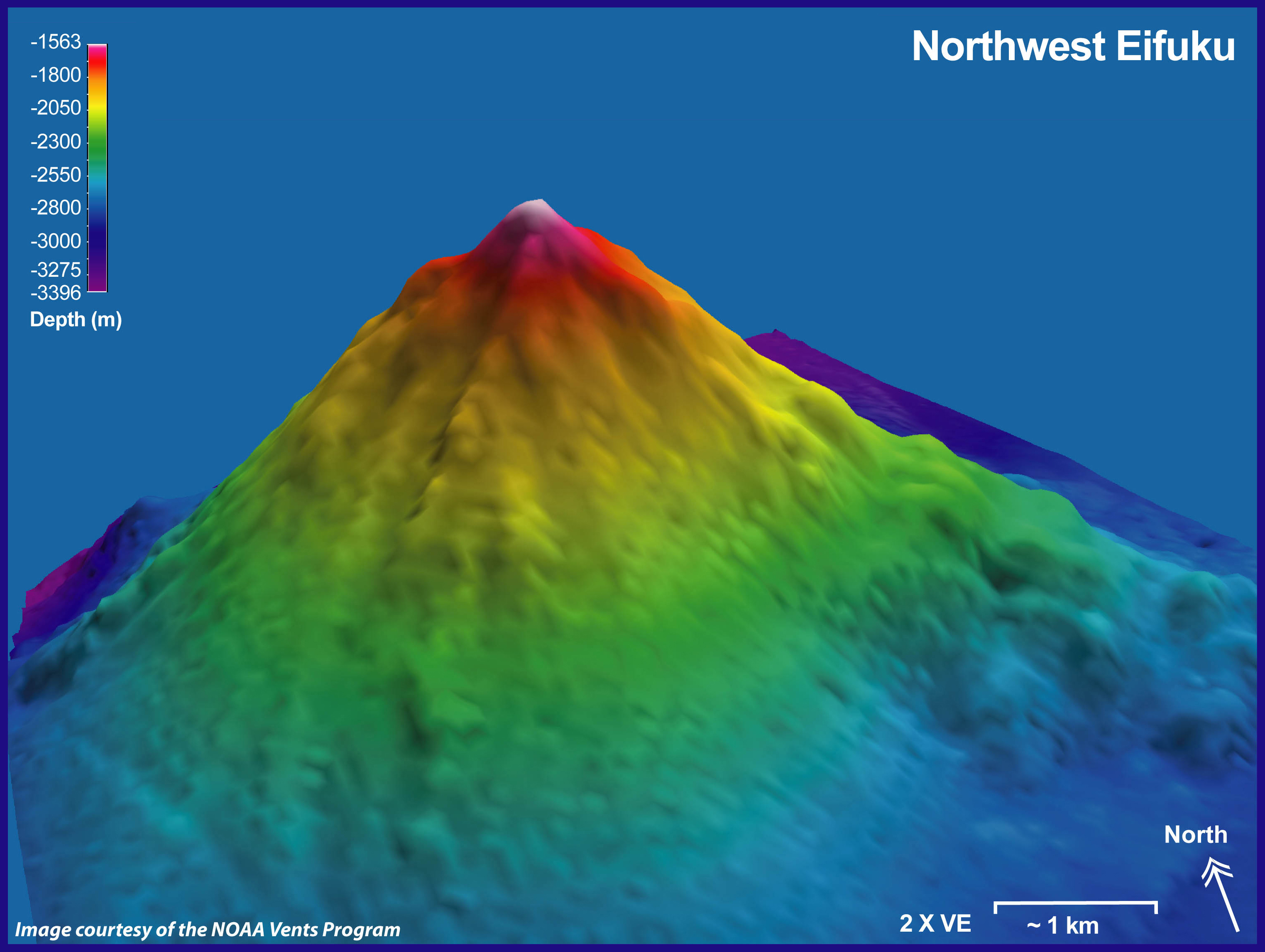
Northwest Eifuku submarine volcano, looking toward the northeast. Depths in this image range from 1,563 to 3,396 m (5,127 to 11,139 ft). Image is two times vertically exaggerated. EM300 bathymetry data resolution is about 35 m at this water depth. Distance indicated is kilometers in foreground.
Download high-resolution image (jpg, 1.87 Mb)
![]() Virtual fly-through of the Northwest Eifuku submarine volcano. (Quicktime, 704 Kb.)
Virtual fly-through of the Northwest Eifuku submarine volcano. (Quicktime, 704 Kb.)

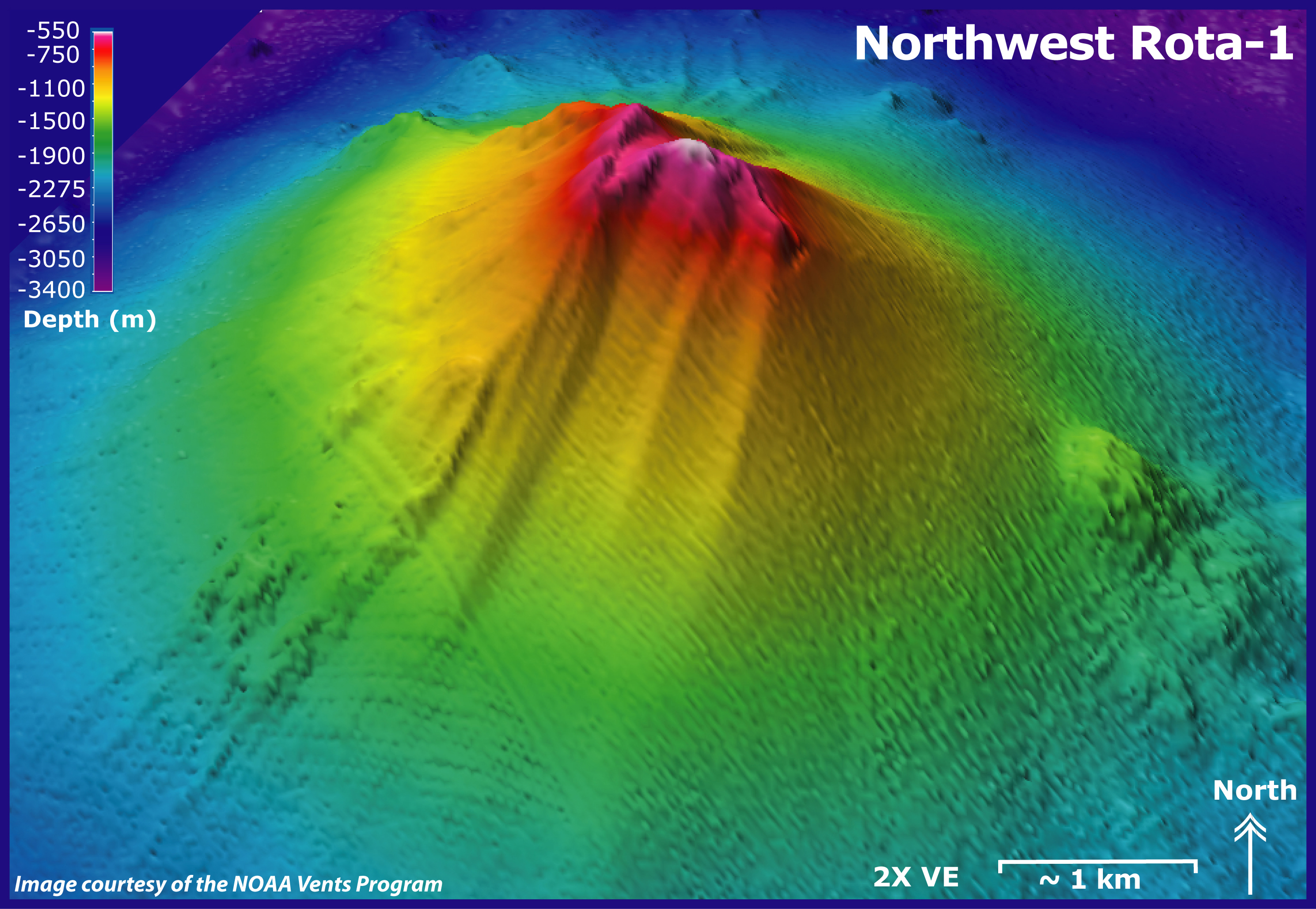
Northwest Rota-1 submarine volcano, looking toward the north. Depths in this image range from 550 to 3,400 m (1,804 to 11,152 ft). Image is two times vertically exaggerated. EM300 bathymetry data resolution is about 30 m. Distance indicated is kilometers in foreground.
Download high-resolution image (jpg, 2.64 Mb)
![]() Virtual fly-through of the Northwest Rota-1 submarine volcano. (Quicktime, 1.3 Mb.)
Virtual fly-through of the Northwest Rota-1 submarine volcano. (Quicktime, 1.3 Mb.)

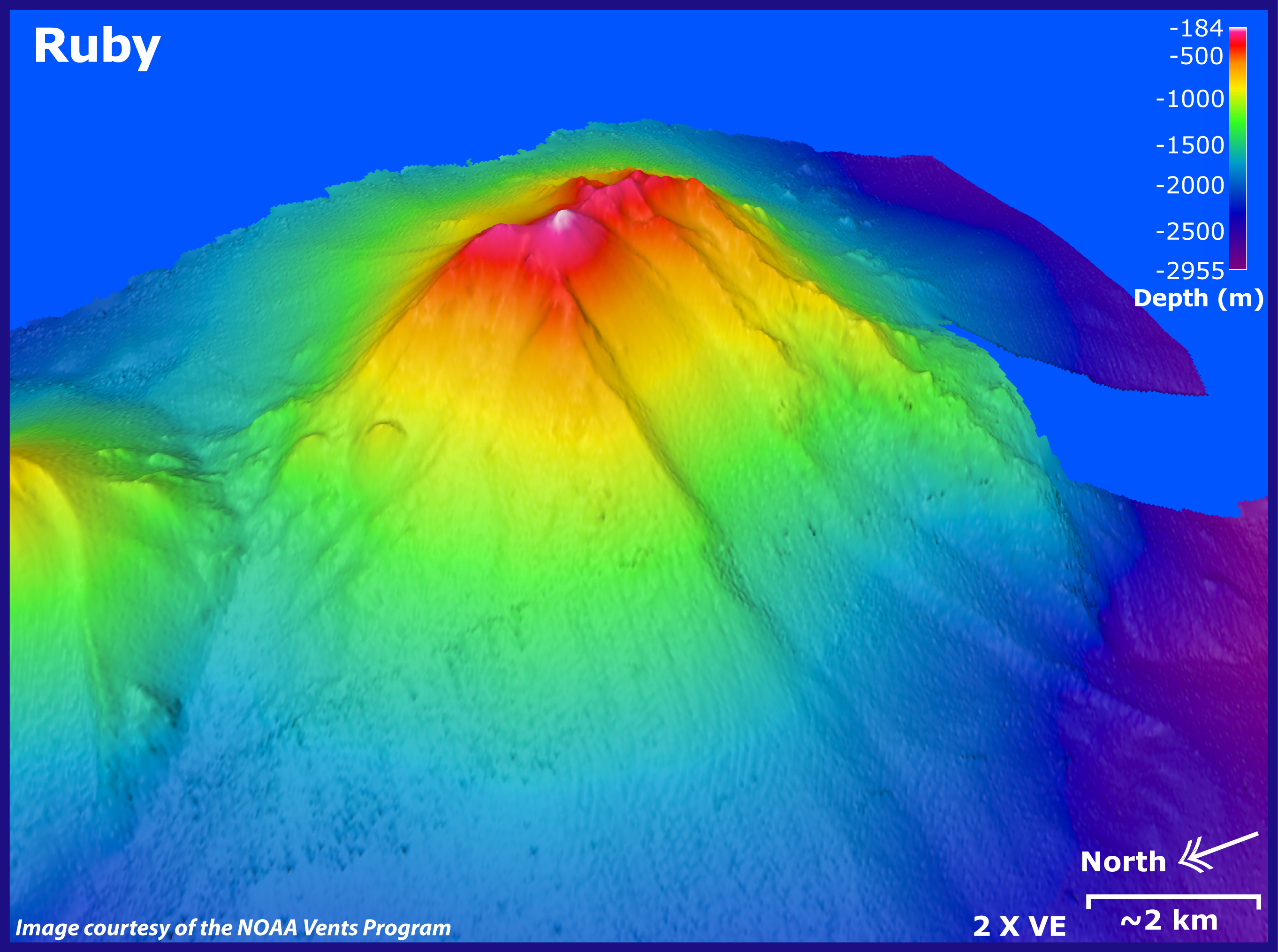
Ruby submarine volcano, looking toward the southeast. Depths in this image range from 184 to 2,955 m (604 to 9,692 ft). Image is two times vertically exaggerated. EM300 bathymetry data resolution is about 25 m. Distance indicated is kilometers in foreground.
Download high-resolution image (jpg, 1.99 Mb)
![]() Virtual fly-through of the Ruby submarine volcano. (Quicktime, 1.1 Mb.)
Virtual fly-through of the Ruby submarine volcano. (Quicktime, 1.1 Mb.)

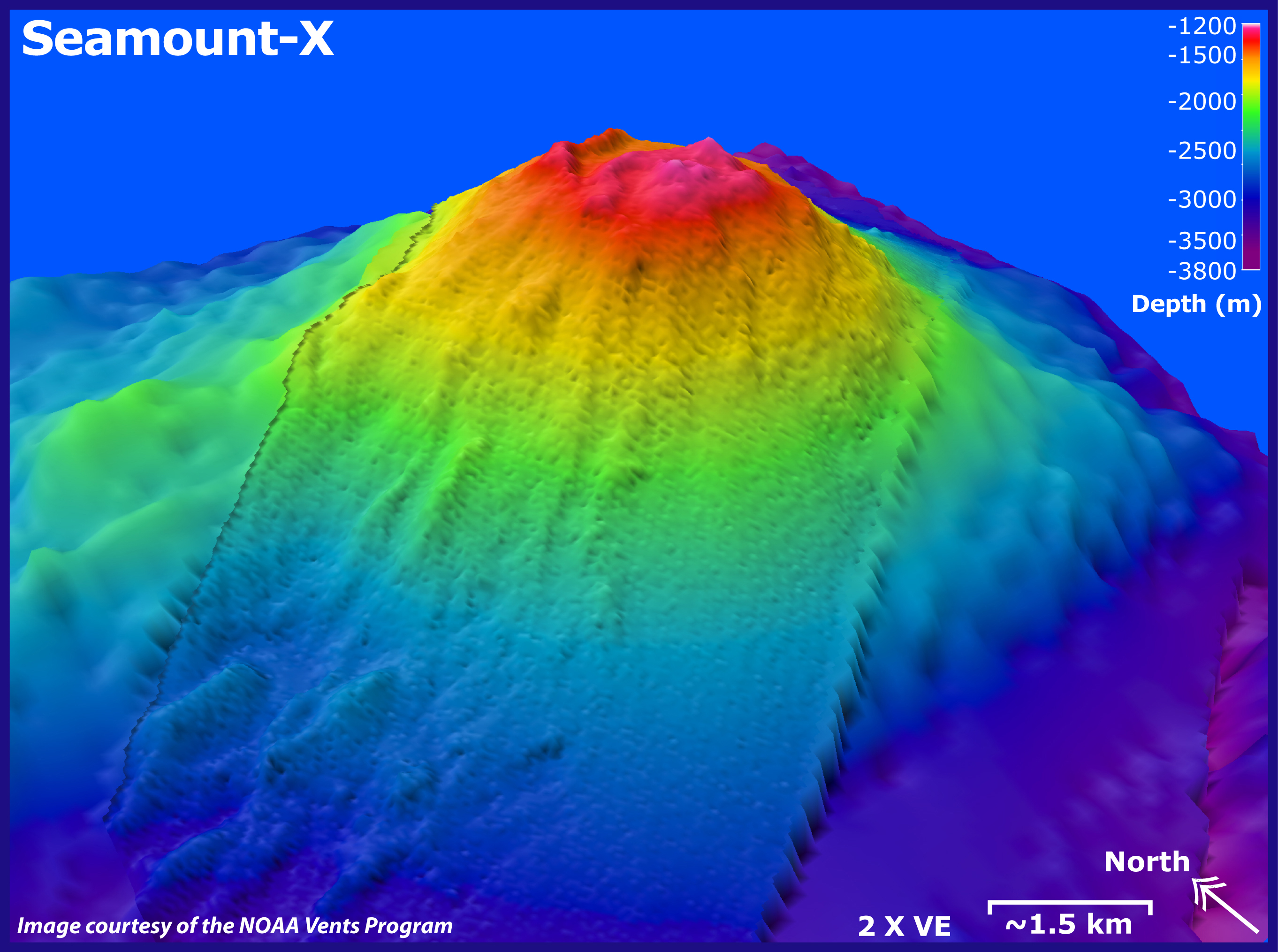
Seamount-X submarine volcano, looking toward the northeast. Depths in this image range from 1,200 to 3,800 m (3,936 to 12,464 ft). Image is two times vertically exaggerated. EM300 bathymetry data (about 35 m resolution at this water depth) overlaid on MR1 data (100-m grid-cell size). Distance indicated is kilometers in foreground. MR1 data courtesy of University of Hawaii.
Download high-resolution image (jpg, 1.8 Mb)
![]() Virtual fly-through of the Seamount-X submarine volcano. (Quicktime, 836 Kb.)
Virtual fly-through of the Seamount-X submarine volcano. (Quicktime, 836 Kb.)

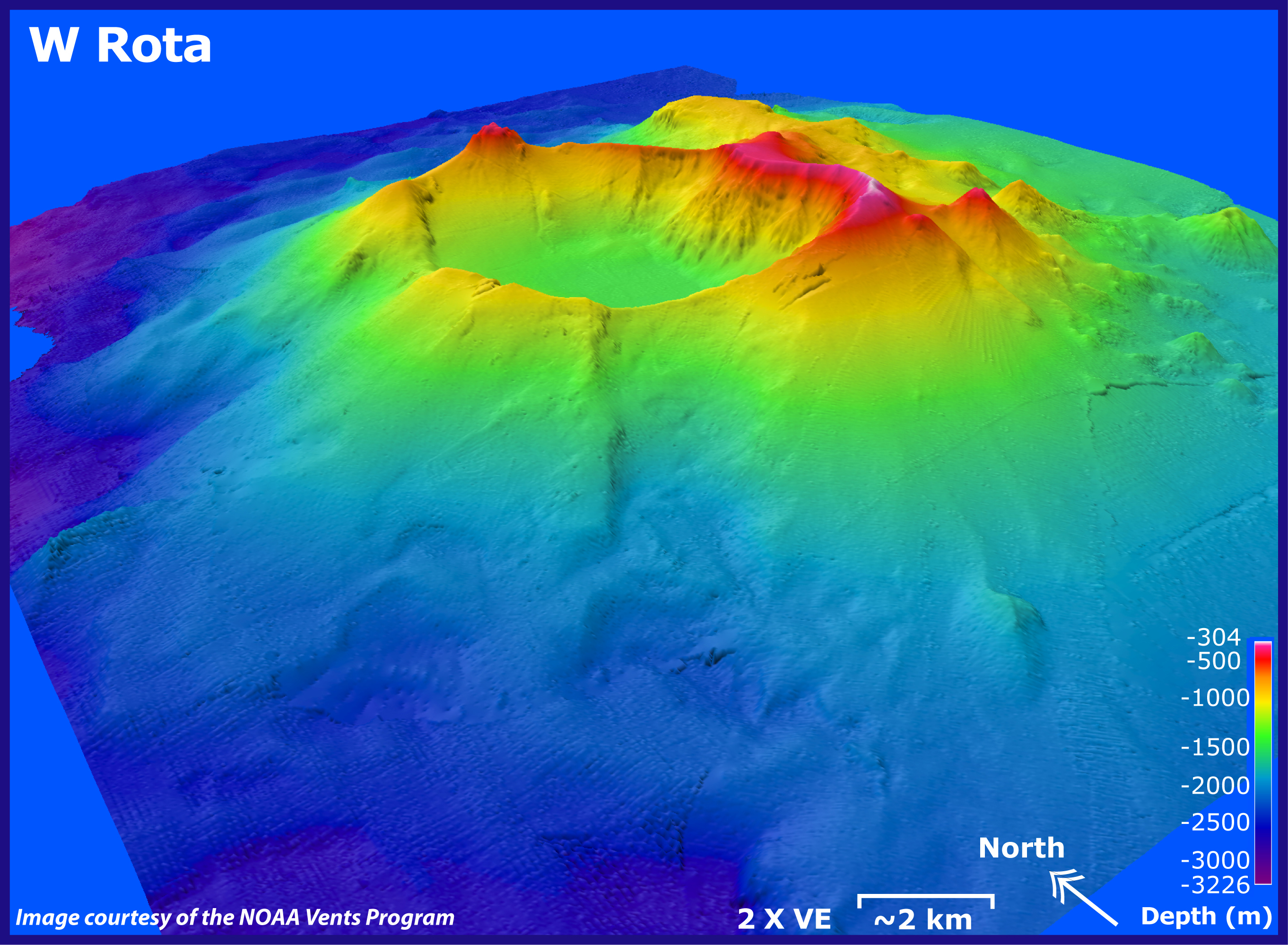
West Rota submarine volcano, looking toward the northeast. Depths in this image range from 304 to 3,226 m (997 to 10,591 ft). Image is two times vertically exaggerated. EM300 bathymetry data (about 30 m resolution at this water depth) are overlaid on SeaBat data (about 50 meter resolution at this depth). Distance indicated is kilometers in foreground. SeaBat data courtesy of Yoshihiko Tamura, JAMSTEC.
Download high-resolution image (jpg, 2.55 Mb)
![]() Virtual fly-through of the West Rota submarine volcano. (Quicktime, 660 Kb.)
Virtual fly-through of the West Rota submarine volcano. (Quicktime, 660 Kb.)

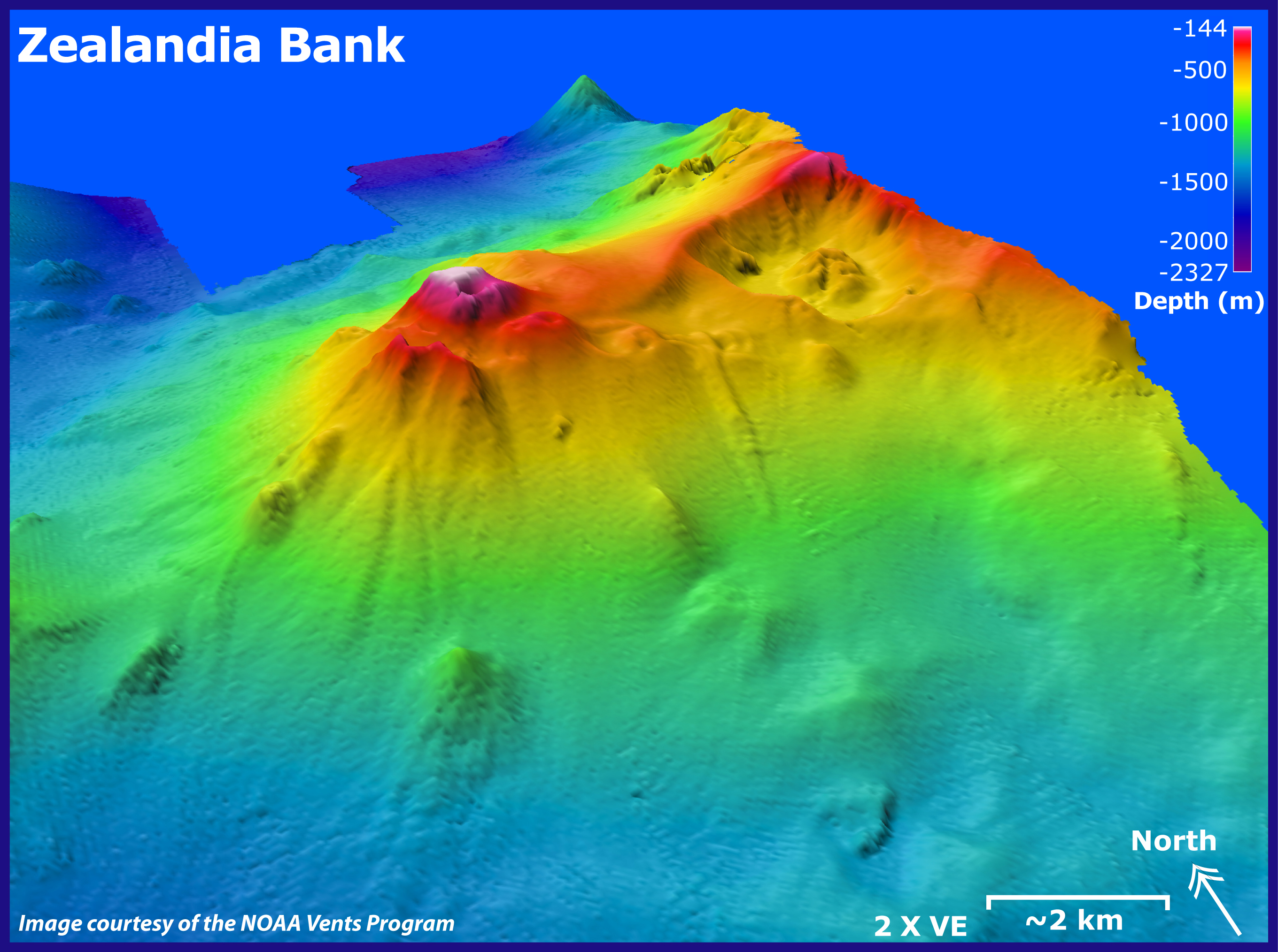
Zealandia Bank submarine volcano, looking toward the northeast. Depths in this image range from 144 to 2,327 m (472 to 7,633 ft). Image is two times vertically exaggerated. EM300 bathymetry data resolution is about 25 m. Distance indicated is kilometers in foreground.
Download high-resolution image (jpg, 1.98 Mb)
![]() Virtual fly-through of the Zealandia Bank submarine volcano. (Quicktime, 1.6 Mb.)
Virtual fly-through of the Zealandia Bank submarine volcano. (Quicktime, 1.6 Mb.)