


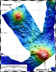
This map shows the location and topography of Seamount X and Forecast. The bathymetry data are a combination of EM300 bathymetry collected on the Submarine Ring of Fire 2004 expedition, and SeaBeam bathymetry collected on this expedition, just prior to diving on Forecast. The contour interval is 200 m; the grid cell size is 50 m. Click image for larger view and image credit.
A view from the bridge of the research vessel (R/V) Melville.
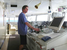
Captain Chris Curl, at the helm, skillfully commands the ship and all
operations. ![]() Click
image for larger panorama view QTVR
Click
image for larger panorama view QTVR
Our First Dives Exploring Seamounts Near Guam
April 21, 2006
Bill Chadwick
Geologist
Cooperative Institute for Marine Resources Studies Program, Oregon State University
NOAA Vents Program, Pacific Marine Environmental Laboratory — Newport,
Oregon
![]() Galatheid crabs (called squat
lobsters) in "flight" at Seamount X.
(Quicktime, 2.1 Mb.)
Galatheid crabs (called squat
lobsters) in "flight" at Seamount X.
(Quicktime, 2.1 Mb.)
![]() Intensely
shimmering water vents from the sea floor atop Forecast seamount.
(Quicktime, 2 Mb.)
Intensely
shimmering water vents from the sea floor atop Forecast seamount.
(Quicktime, 2 Mb.)
The research vessel (R/V) Melville is now our "home away from home." For the next month, the ship will be the platform that supports the exploration and science we hope to accomplish during this expedition. Our primary tools will be the remotely operated vehicle (ROV) Jason II for observing and sampling on the sea floor, the CTD (an instrument that measures conductivity, temperature, and depth) for surveying hydrothermal plumes above the sea floor, and the ship's multibeam sonar for bathymetric mapping. Our goal is to explore a group of submarine volcanoes that are likely to lead to new discoveries.
After months of preparation and days of loading in port, we departed Guam on a hot, sunny day, and only five hrs later we were at our first dive site. Our first dives with ROV Jason II were on two seamounts in the southern Mariana arc that are located near the backarc spreading center axis, are relatively deep (1,200 to 1,450 m; or 4,000 to 4,750 ft), and are hydrothermally active. Most of the submarine volcanoes on the Mariana arc are shallow and located far from the backarc. Therefore, we were anxious to visit these two seamounts to explore the effect of these differences (distance from the backarc and depth of their summits) on their hydrothermal systems.
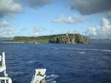
A last glimpse of the island of Guam as the R/V Melville heads out of the harbor and steams toward Seamount X, the first remotely operated vehicle (ROV) Jason II dive site on the Submarine Ring of Fire 2006 expedition. Click image for larger view
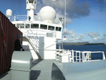
The bow of the R/V Melville as
she steams out of the harbor. ![]() Click
image for larger panorama view QTVR.
Click
image for larger panorama view QTVR.
Our first dive site was at Seamount X, where we conducted a CTD tow in 2003 and found a strong hydrothermal plume near the summit. We found thick deposits of microbial mat and diffuse venting sites colonized by shrimp, crabs, and scale worms. The highlight was near the end of the dive when we found an extraordinarily large deposit of sulfur that was covered with literally thousands of galatheid crabs (also known as "squat lobsters). It was unclear what attracted the squat lobsters to the sulfur, but we suspect that they may be feeding on microbial mats that are growing on their own bodies! The thick sulfur deposit had clearly been formed by innumerable flows of molten sulfur coming out of the hydrothermal system. It was yet another amazing setting where a submarine volcano is supporting marine life.
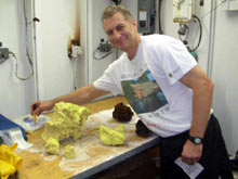
Cornel de Ronde sorts through the geological samples collected at Seamount X. Among the samples are huge pieces of sulfur (yellow, in the center foreground) and two pieces of basalt (reddish black, background). Click image for larger view and image credit.
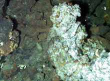
A glimpse of a biological community at a Forecast vent site. The species found here and in the Mariana backarc spreading center differ from those found on the Mariana arc seamounts to the north. Click image for larger view and image credit.
Our second dive was at Forecast seamount, located just 10 mi away. The highlight of this site was the occurrence of hydrothermal fluid temperatures up to 200°C, one of the highest-temperature vent systems known in the Mariana arc. The biological communities at these vents include shrimp, snails, limpets, crabs, sulfide worms, and scale worms. But a fascinating relationship is emerging: the species that occur here and in the Mariana backarc spreading center differ from those on the seamounts of the Mariana arc to the north. The animals we find on Forecast seamount are more similar to those at Alice Springs — several hundred kilometers to the north — than they are to Seamount X, NW Rota-1 volcano, and the rest of the arc. Further sampling will help us examine the reasons for the difference.
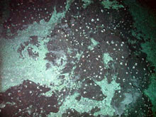
These squat lobsters at Seamount X are living upon a huge sulfur deposit at Seamount X. Click image for larger view and image credit.
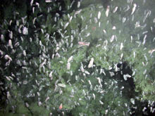
The plethora of squat lobsters at Seamount X disperse as the Jason II comes in for a closer view. Click image for larger view and image credit.
We are now headed for NW Rota-1 volcano, the site of the underwater eruption we discovered in 2004 and revisited in 2005 with the Japanese ROV Hyper-Dolphin. Is it still actively erupting ash? Standby!
Sign up for the Ocean Explorer E-mail Update List.