


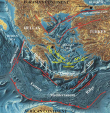
Simplified geotectonic map of Eastern Mediterranean and Aegean Sea. Click image for larger view and image credit.
Geological Frame
Dr. Dimitris Sakellariou
Chief Scientist
The Eastern Mediterranean domain is a unique environment in terms of active geodynamics and plate movements. The Eastern Mediterranean oceanic basin represents the last descendant of Tethys, a 200 million year old ocean, which disappeared due to the convergent motion of two continents: the Eurasian and the African-Indian continents. The collision of these two continents gave birth to some of the highest mountain ranges on earth, such as the Himalaya, Alps, Caucasus and others. Presently the last remnants of this ocean are being consumed by the fast (5 mm/yr) Africa – Eurasia collision, and the associated NNE-ward subduction beneath the Hellenic Orogenic Arc. Active subduction processes and ongoing migration of the continental and oceanic crustal plates led to the formation of a complicated geodynamic structure. Westward movement of the Minor Asia crustal block along the North Anatolian Fault, the one that moved during the catastrophic 1999 Istanbul earthquake, adds more complexity to the geodynamic organization of the area.
Subduction of the Eastern Mediterranean lithosphere (the earth’s crust and upper mantle) beneath the Hellenic Orogenic Arc, and the following melting of the sinking sediments and rocks resulted in the formation of spectacular volcanoes and related volcanic structures in the Southern Aegean Sea. The volcanoes are aligned along a 500km long by 40km wide concave arc, known as the Hellenic Volcanic Arc. Some of the most famous South Aegean islands, like Santorini, Nisyros, Milos, Egina and Poros, together with other minor volcanic outcrops, represent the main volcanic centers of the Hellenic Volcanic Arc.
For decades long, dozens of geologists, volcanologists, geochemists, seismologists and geophysicists have worked on the islands of Santorini and Milos, and have produced a huge amount of data on the structure, the geochemical characteristics, the seismicity and the present situation of the volcanic activity. It has only been in the last decade that systematic marine geological surveys were conducted by HCMR around Nisyros volcanic island, and very recently in the offshore area surrounding Santorini Island and the Columbo submarine volcano.
The oldest volcanic products on Milos Island are pyroclastic deposits and pillow lavas from 3.0 – 3.5 million years (Late Pliocene) ago. Northeast-Southwest to North-South trending faults may have been used as conduits for the magmatic fluids on their way to the surface. Four major phases of volcanic activity may have taken place in the Milos volcanic center since the Late Pliocene age. The youngest phase occurred in the Mid to Late Pleistocene period. Radioactive dating determined the youngest rhyolite (the volcanic form of granite) flow on the island to ages of 140 thousand years! A spectacular, 1.5km diameter tuff ring at Fyriplaka is the youngest and most hydrothermally active volcanic crater on the island. Milos is the largest source of bentonite (a light-colored, valuable clay) in Europe. Bentonites are primarily calcium and sodium chloride-rich montmorillonites (soft clay deposits) and occur in depressions filled with volcanic material. Apart from recent exploitation of volcanic deposits, there is strong evidence that obsidian from Milos Island has been used and transported to many places in the Aegean and the Mediterranean Sea since Neolithic times. Obsidian, a black colored volcanic glass, has been used by Neolithic man for the construction of various tools. It has been geochemically and isotopically proven that obsidian tools found in the Frachthi Cave, northeast Peloponese, date as far back as 7000 BC and came from Milos. This provides strong evidence that maritime transportation in the Aegean Sea occurred during Neolithic times!
Active hydrothermal venting sites have been observed on the seafloor around Milos Island. The most prominent submarine hydrothermal field occurs off the southeastern coast of the island, at depths of 100-150m. They were previously discovered by echo-soundings, and some have been visually inspected by remotely operated (ROV) or human occupied (HOV) vehicles.
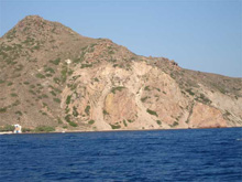
Reddish rhyolitic domes on Milos island. Click image for larger view and image credit.
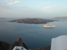
The Nea Kameni island in the middle of Santorini caldera is the summit of the presently active volcanic centre. Click image for larger view and image credit.
This particular hydrothermal field off of southeast Milos will be the first survey area during Project PHAEDRA 2006. The shallow depth of the area will allow us to set up and test all equipment mounted on HCMR’s Thetis HOV and Seabed AUV. We hope, for the first time ever, to be able to measure the concentrations of gases emitted from the vents on the seafloor by using the Gemini mass spectrometer mounted on the Thetis HOV. Niskin bottles (1lt) and push cores, carried by Thetis will collect water samples and sediment short cores from the active sites. The SeaBED AUV will perform further oceanographic measurements and micro bathymetry on sites of interest.
Santorini caldera and the submerged Columbo volcano will be the next two survey areas of this project. Santorini, the most spectacular island in the Aegean Sea owes its exceptional landscape to the Minoan eruption in the 17th century BC and the formation of the famous caldera in the middle of the island. The caldera walls rise to over 300m above sea level while maximum depth of the caldera seafloor is about 360m. The Minoan eruption is considered the second largest eruption in historical times, after the Tambora volcano eruption in Indonesia in 1815.
The oldest volcanic products of Santorini are 1.5-1.6 million years old, considerably younger than those of Milos. Several eruptive cycles are distinguishable on the island with the Minoan eruption being the most recent. Minoan ash forms a white colored cap over the island up to 50m thick. Beneath that cap are successive multicolored lava layers, pyroclastic flows, ash deposits and other volcanic formations exposed on the upright caldera walls, providing witness to the diverse volcanic history of the island.
Since the devastating Minoan eruption in the 17th century BC, many significantly weaker activity phases have occurred, and the landscape has continued to change even during very recent years. The Nea Kameni island in the centre of the caldera forms the summit of the actively growing new volcanic center. The ancient geographer Strabo was the first to record volcanic eruptions inside the Santorini caldera. He described the birth of a newly formed small island in 197 BC in the middle of caldera. Several eruptive phases followed the birth of Kameni islands in the years 46-47, 726, 1570-1573, 1707-1711, 1866-1870, 1925-1928, 1938-1941 and 1950 AD as the most recent eruption.
Hydrothermal venting and formation of carbonate mounds and bacterial communities associated with the active hydrothermal sites on the seafloor have been reported previously from several places off the coasts of Nea Kameni as well on the caldera’s seafloor.
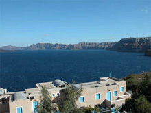
View of Santorini caldera from south. Click image for larger view and image credit.
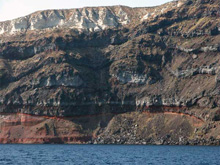
Ash layers, lava flows, pyroclastic deposits and other volcanic products exposed on the steep caldera walls of Santorini. Click image for larger view and image credit.
Columbo submarine volcano appeared first in 1650 AD some 8 km to the northeast of Cape Columbo, Santorini island. The strong sublinian eruption of Columbo lasted for 2-3 months, between September and December 1650. It produced ash and pumice fall and triggered a very strong tsunami, which devastated the coasts of the adjacent South Aegean islands. Toxic gases, emitted during the eruptive phase, was one of the reasons for the over 50 fatalities. A small island rose above the sea level at the place where the present day Columbo bank lies and disappeared shortly after. Nowadays the 18m Columbo bank represents the shallowest point of the submarine volcanic cone, on the rim which surrounds the 500m deep crater. The diameter of the crater rim is about 1.5km while the crater’s bottom is less than 500m in diameter.
Columbo submarine volcano is the biggest of several volcanic cones aligned in a northeast-southwest direction in the Anyhdros basin, to the northeast of Santorini. The Anyhdros basin is a 400-500m deep basin controlled by northeast-southwest trending faults. Steep slopes, developed along the marginal faults, bound the subsiding basin’s floor. Vertical and strike slip movements along steeply inclined fault surfaces result from the subsiding basin, and the deformation of the sedimentary deposits in it. The linear layout of the volcanic cones parallel to the main marginal faults of Anyhdros basin indicate that tectonic features may have played a main role in the spatial distribution of the submarine volcanoes.
Active venting sites have been recently discovered and visually observed in the deep bottom of Columbo crater.
All three previously described volcanic fields, namely SE Milos, Santorini caldera and Columbo volcano, will be the areas surveyed with the Thetis HOV. Each field will be investigated for their geochemical and isotopic characteristics using the Gemini mass spectrometer, mounted on Thetis. Water samples and sediment short cores will be collected, and comparative analyses will be carried out. Further on, microbathymetry of the most interesting sites will be performed with the Seabed AUV to record microstructures associated with the hydrothermal activity. Biological samples, such as bacterial mats or other benthic organisms, will be collected near the active sites.
By using new technologies such as Gemini, the expedition scientists will be able to better characterize these geochemical features, providing new insight into deep earth processes. The geochemical data gathered by these instruments will allow geologists to compare the geochemical characteristics of the Milos offshore hydrothermal field, Santorini caldera, Columbo volcano and neighbouring hydrothermal sites with other active sites in the Hellenic Volcanic Arc system, and throughout the world. These data will also indicate what types of biochemical pathways are available and if these pathways are being used, providing clues whether chemosynthetic organisms or other types of life are present.
Sign up for the Ocean Explorer E-mail Update List.