


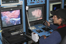
Coral colonies come into view on the pilot's monitors. A small piece of the Primnoa colony is sampled to confirm its identification. Click image for larger view and image credit.
Like Ornaments on a Christmas Tree – Diary of a Dive
June 3, 2006
Mary Sue Brancato
It was our last ROV dive of the survey and we were running out of time. The McArthur II’s captain, Greg Hubner, required that we recover the ROV no later than 1800 hrs in order to steam back to Victoria B.C. to unload the equipment and head for home.
We finally finished the transects with about one hour to spare, so Jeff Hyland and I decided to head for the next closest study area in hopes of finding rock. Off we headed at top ROV speed (~2.5 knots) sticking close to the bottom so we could still see what kind of habitat we were traveling over. We also scanned the obstacle-avoidance sonar for any signal of red, which would mean rock.
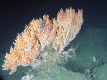
Primnoa colony with Florometra crinoids and Gorgonocephalus basket stars at its base. Click image for larger view and image credit.
I climbed the stairs to the captains’ cabin to literally beg for more time. Fortunately, Captain Hubner, was at that very moment, watching the live video feed of the dive and seeing the coral as it came into view. He granted us a 30-minute extension on the dive. And oh, what coral to find—the largest yet, over a meter tall and a meter wide Primnoa colonies. Peach-colored “foliage” surrounded by all sorts of invertebrates, Florometra crinoids and Gorgonocephalus basket stars surrounding them like Christmas presents and rockfish nestled on each of the branches, like ornaments on a tree! After exploring and photographing the scene, we raced to the next spot that the sonar was showing rock and again, more coral.
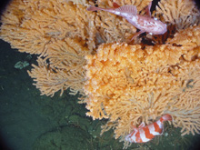
Looking down on the Primnoa colony you can see redbanded and darkblotched rockfish nestled in the branches. Click image for larger view and image credit.
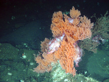
Primnoa colony “ornamented” with rock fish (Darkblotched and Sharpchin rockfish). Click image for larger view and image credit.
By now some of our fellow scientists and ROV operators had heard our excited shouts, and though not on shift, they came to join us, including co-PI Ed Bowlby. He was the next to run up to the Captain Hubner’s cabin to beg for more dive time! He granted another 10 minutes. We laughed and told Jeff Hyland he was next in line to beg. The room was filled with excitement at the find. Scientists, ROV operators and the navigation crew alike, were excited as we dashed from one spot to the next.
Finally, Keith Shepherd, the supervisor for the ROPOS ROV, said we had to come up, and alas, the dive came to an end. But what a glorious end to a successful cruise, with the memory of coral branches moving in the current with rockfish ornamenting their branches! And we vowed to return.
Last Day’s Reflection
June 3, 2006
Ed Bowlby
Olympic Coast National Marine Sanctuary
After witnessing the last hour of the last dive of the cruise where lush red tree corals (Primnoa species) were festooned with colorful rockfish in their branches (underwater equivalents of tree squirrels?), I took my adrenalin rush to the ship’s bow. While the ROV was being retrieved on the aft deck, I gazed off to the ocean horizon to reflect on the success of the cruise. I was rewarded by the sight of a humpback whale blowing in the distance and a black-footed albatross gliding nearby.
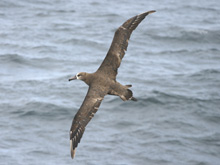
A black-footed albatross (Diomedea nigripes) glides across the ocean. Although they nest in the Hawaiian Islands, these birds are commonly seen in the offshore areas of the Olympic coast during their feeding flights. Click image for larger view.
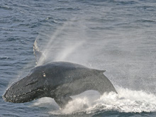
Humpback whale (Megaptera novaeangliae) breaching. Humpbacks migrate from their winter breeding areas to feed in the productive offshore waters of the sanctuary. Click image for larger view.
This was a perfect encapsulation of the biodiversity of this area. Not only had we just observed a highly diverse seafloor community of lush soft corals and rockfish, but the ocean’s surface waters teemed with a rich soup of plankton and small fish, attracting surface feeders such as seabirds and marine mammals as well as fishermen in their boats. This larger area has been called the ‘Big Eddy’ as a nickname for the Juan de Fuca eddy that spins across the boundary waters of the U.S. and Canada. Both countries consider this area important not only for its biodiversity but also for its socioeconomics, including aboriginal use by tribes in the U.S. and by First Nations in Canada. It has become a focal study area to determine its ecological role in producing seasonal harmful algal blooms.
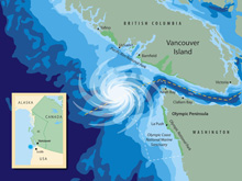
A stylized map of the ‘Big Eddy’, the seasonal eddy formation occurring within the boundary waters of the U.S. and Canada. Click image for larger view and image credit.
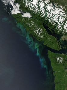
A satellite image of the northwestern tip of the Olympic Peninsula in Washington state and the southern portion of Vancouver Island, Canada. The ‘Big Eddy’ occurs seasonally in the offshore waters between the two countries, contributing to the amazing ocean productivity of the area. Click image for larger view and image credit.
After 12 days and nights of round the clock survey efforts, I was exhausted yet exuberated by the success of the cruise. Our team of scientists, ROV technicians, and ship’s crew all deserved a heartfelt thanks. The new information we returned with, both photographs and samples, will increase our knowledge of the area and help decision makers to assess overall management needs.
To read more background on the ‘Big Eddy’, click on the following website: http://www.bigeddy.net/ ![]()
To read about investigations on harmful algal blooms in the Juan de Fuca eddy (‘Big Eddy’), click on the following website:
http://www.ecohabpnw.org/ ![]()