

This mission marks the second year the United States and Canada have collaborated to collect data on the extended continental shelf in the Arctic.
![]() Click image to view a slide show.
Click image to view a slide show.
Extended Continental Shelf Project 2009
August 7 – September 16, 2009
The United States, like every coastal country, has a continental shelf that measures out to 200 nautical miles from the shore. This area is sovereign territory; in fact, the U.S. has more submerged territory than it does dry territory. Under international law, the U.S. and other coastal nations can extend their territories beyond the 200-nautical-mile limit if certain criteria, as specified in the Convention on the Law of the Sea, are met. Defining and establishing the limits of the extended continental shelf — the area beyond 200 nautical miles from shore — enables the U.S. to develop, conserve, and protect the seabed and subsoil resources found there.
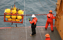
The Extended Continental Shelf Project 2009 is a joint U.S. and Canadian mission to survey the Arctic continental shelf. Two icebreakers, sturdy ships built for passage through ice, have already embarked on the 41-day project to the survey area. From August 7 to September 16, U.S. Coast Guard (USCG) cutter Healy and the Canadian Coast Guard ship Louis S. St-Laurent will collect and share data useful to both countries in defining the full extent of the Arctic continental shelf.
Chief scientist for the U.S. mission is Larry Mayer, director of the Center for Coastal and Ocean Mapping and co-director of the Joint Hydrographic Center (JHC). The co-chief scientist is NOAA's Andy Armstrong, a physical scientist who is co-director of the JHC. NOAA and the University of New Hampshire jointly operate the JHC.
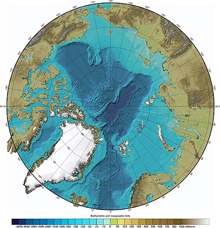
This international bathymetric (water depth) chart of the Arctic Ocean is a composite based on sparse data. Click image for larger view and image credit.
Deborah Hutchinson, a scientist from the U.S. Geological Survey, will be based on the Canadian icebreaker to coordinate seismic data collection with counterparts from the Canadian Geological Survey, Natural Resources Canada. A Canadian scientist will ride aboard the USCG Healy.
NOAA's Pablo Clemente Colón, chief scientist at the U.S. National Ice Center, will coordinate the deployment of buoys to monitor ice, atmospheric, and upper-ocean thermal conditions in the Arctic ocean as part of the International Arctic Buoy Program and the Arctic Observing Network efforts.
Christine Hedge, a school teacher from Carmel Middle School in Carmel, Indiana, will be the NOAA Teacher at Sea on board the Healy as part of the annual Arctic sea-floor mapping cruise series. Sponsored by NOAA National Marine Fisheries Service and NOAA Office of Marine and Aviation Operations, the NOAA Teacher at Sea program offers educators the opportunity to interact with scientists on vessels and to develop lesson plans and activities for implementation back in the classroom. On this mission, Hedge will learn more about hydrography (the mapping, description, and physical analysis of surface water), as well as ecosystems and resources within the North American extended continental shelf.
Members of the U.S. Extended Continental Shelf Task Force are the U.S. Department of State, National Oceanic and Atmospheric Administration, Department of the Interior, Executive Office of the President, U.S. Geological Survey, U.S. Coast Guard, National Science Foundation, Joint Chiefs of Staff, U.S. Navy, Department of Energy, Environmental Protection Agency, Minerals Management Service, and the Arctic Research Commission.
Sign up for the Ocean Explorer E-mail Update List.