Marine Archaeological Investigation and Habitat Mapping of the Paleo-Suwannee River
Past Expedition
Overview
By Vincent Lecours – University of Florida’s Institute of Food and Agricultural Sciences
This underwater archaeological investigation of the Paleo-Suwannee River channel and its surroundings is expected to yield critical new information about potential sites of cultural heritage, which might contribute to the area being considered an Underwater Archaeological Preserve.
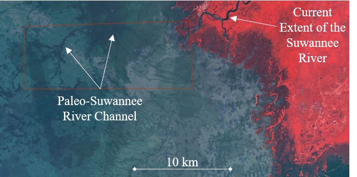
Map showing the location of the Paleo-Suwannee River channel relative to the current extent of the Suwannee River off the Gulf Coast of Florida. During the Marine Archaeological Investigation and Habitat Mapping of the Paleo-Suwannee River expedition, scientists will map a section of the Paleo-Suwannee River channel and tidal creeks to evaluate the presence or absence of submerged archaeological sites. Image courtesy of Marine Archaeological Investigation and Habitat Mapping of the Paleo-Suwannee River. Download largest version (jpg, 66 KB).
Current evidence for the earliest human presence in Florida dates back to approximately 14,550 years ago when the coastline was roughly 200 kilometers (124 miles) seaward from today’s northern Gulf Coast. Archaeological evidence from around the world suggests that humans have long benefitted from the resources the oceans offer, and past terrestrial and underwater archaeological studies confirm that this was also true in Florida.
The Suwannee River and its surroundings have been identified as among the locations with high archaeological potential in Florida. Based on what we currently know, it is likely that prehistoric people once also inhabited the shores of a segment of the Suwannee River that is now submerged beneath the Gulf due to past sea level rise. This submerged portion forms what is known as the Paleo-Suwannee River.
Map showing the location of the Paleo-Suwannee River channel and tidal creeks that will be explored during the Marine Archaeological Investigation and Habitat Mapping of the Paleo-Suwannee River expedition, relative to Florida. Image courtesy of Marine Archaeological Investigation and Habitat Mapping of the Paleo-Suwannee River. Download largest version (jpg, 580 KB).
During this expedition, the team will map a section of the Paleo-Suwannee River channel and tidal creeks to evaluate the presence or absence of submerged archaeological sites. Acoustic remote sensing technologies will be used to produce a three-dimensional model of the seafloor and a map of its acoustic reflectivity, which can inform on sediment characteristics and distribution. Each day of fieldwork will include launching an autonomous surface vehicle equipped with a multibeam echosounder sonar system that will collect data on the seafloor underneath the vehicle. The resulting data will then be used to generate geomorphological maps of the area and inform the selection of targets for underwater archaeologists to investigate in a future phase of this project.
While the autonomous surface vehicle follows the pre-defined survey lines, the team will collect video data using a small remotely operated vehicle and a GoPro HERO9 camera. These video data will be used to identify the top layer of sediments on the seafloor, in addition to providing visual evidence of which marine species live in the area. Sediment and species observations will be combined with the acoustic data to produce marine habitat maps of the study area.
Why It Matters: Florida’s coastal communities are intimately connected to the marine environment, which is a source of economic revenue, health, and identity for the people living in these communities. This project has the potential to bolster the fact that this connection has existed for thousands of years. The maps and data products that will be generated will inform safe navigation and the management, sustainable use, and conservation of marine resources in a previously unsampled area of the U.S. Exclusive Economic Zone while improving our understanding of an important ecosystem and geosystem in this region of Florida.
Features
Features provide a deeper dive into expedition-related topics.


