Interagency Public-Private Partnership Sends Uncrewed Saildrone to Explore Remote Alaskan Waters
View Update | View Project Summary
On August 11, 2022, the Saildrone Surveyor departed Dutch Harbor in Alaska’s Aleutian Islands, embarking on a multipartner project to better understand the ocean and seafloor in one of the most remote and understudied parts of the United States. NOAA Ocean Exploration and the Bureau of Ocean Energy Management (BOEM) are the primary sponsors of this work.

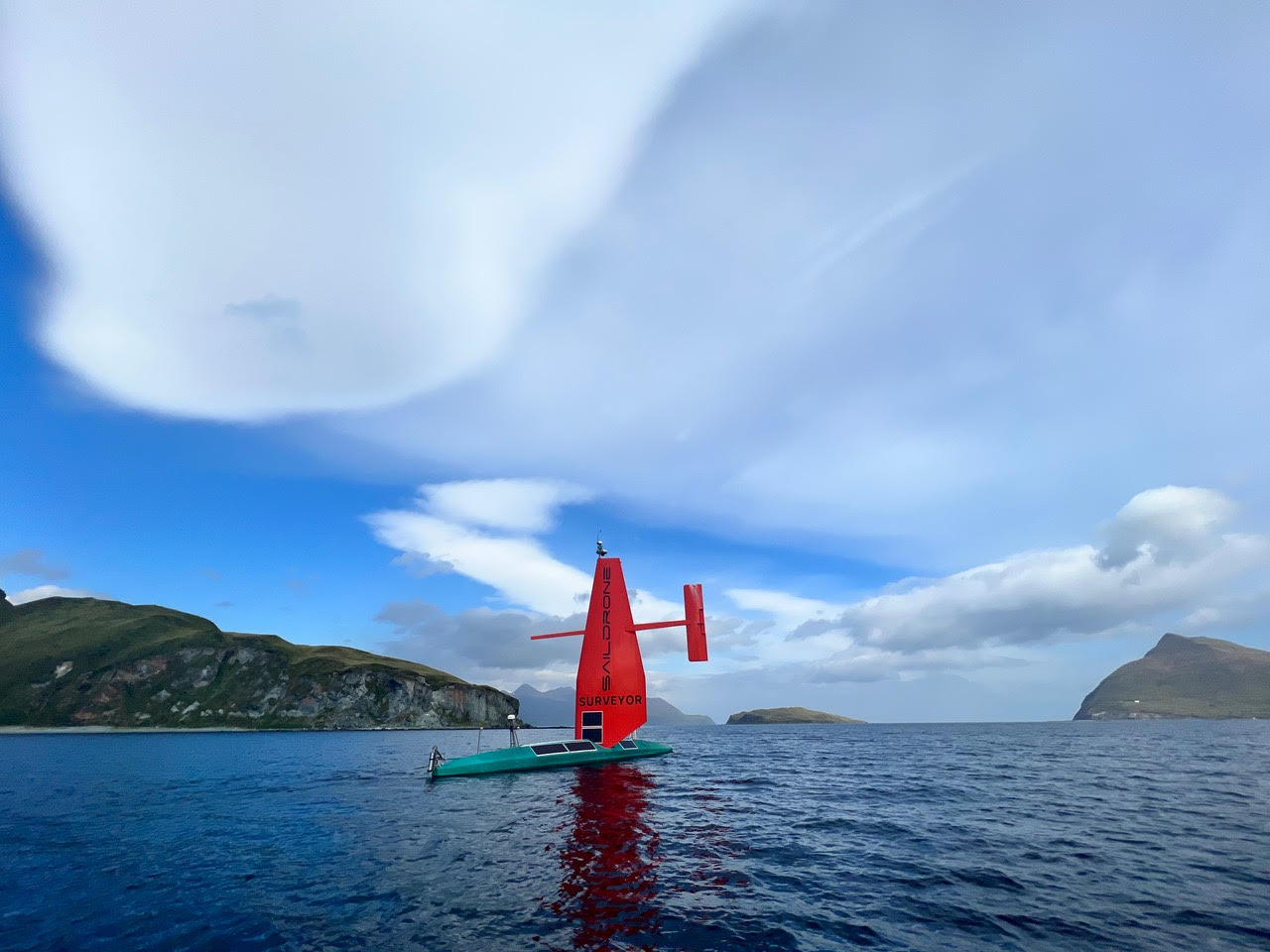
The Saildrone Surveyor in Alaska’s Dutch Harbor at the beginning of the Aleutians Uncrewed Ocean Exploration expedition. Image courtesy of Saildrone. Download largest version (3.3 MB).
The Aleutians Uncrewed Ocean Exploration expedition is a public-private partnership facilitated and led by the NOAA Ocean Exploration Cooperative Institute . The goal of the expedition is to collect ocean mapping and environmental data in unexplored waters around the Aleutian Islands identified as high priority for NOAA, BOEM, the U.S. Geological Survey, and the broader federal Interagency Working Group on Ocean Exploration and Characterization. All work conducted will contribute to the Seascape Alaska regional mapping campaign.
Data will be collected by the innovative Saildrone Surveyor , the world’s largest and most advanced uncrewed surface vessel for ocean exploration. Along with Saildrone , the University of New Hampshire’s Center for Coastal and Ocean Mapping and NOAA Ocean Exploration staff will manage at-sea operations.
The Surveyor is equipped with a suite of instruments to collect acoustic, oceanographic, and meteorological data to support a wide range of research applications. Piloted remotely from shore and powered primarily by wind and solar energy, the environmentally friendly Surveyor leverages the latest technologies. This addition to the fleet of deep-ocean exploration platforms should enable long-term missions at sea in some of the most remote corners of the ocean.
Ocean data are critical to informing our understanding of important issues such as sustainable use and stewardship of ocean resources (including fisheries, offshore energy, and seabed minerals), safe navigation, hazard assessment, national security, and climate change. But, the ocean is vast, and data gaps are significant. As of January 2022, only 31% of Alaskan waters had been mapped at high resolution (100-meter), with even less explored or characterized.
In general, seafloor mapping is difficult, time consuming, and expensive. Yet, ambitious seafloor mapping goals have been set by the U.S. National Strategy for Mapping, Exploring, and Characterizing the United States Exclusive Economic Zone and the global Seabed 2030 initiative. The Aleutians Uncrewed Ocean Exploration expedition partners are working together toward these goals by leveraging shared resources and expertise to increase the pace, efficiency, and affordability of seafloor mapping.
Beyond mapping, the Surveyor will also carry revolutionary technology from MBARI (Monterey Bay Aquarium Research Institute) to sample environmental DNA. Also known as eDNA , this genetic material can reveal important clues about marine biodiversity and, ultimately, ocean health. MBARI’s Environmental Sample Processor (ESP) is a “lab in a can” that will collect and preserve eDNA samples during the expedition. Pairing this powerful tool with uncrewed robotic technologies such as the Surveyor will enable researchers and resource managers to better understand the health of parts of the ocean that are not easily accessible with crewed research ships.
“This project is an excellent example of how federal agencies and partners from industry, academia, and research institutions can coordinate resources and leverage state-of-the-art technology to explore a remote area together,” said Jeremy Weirich, director of NOAA Ocean Exploration. “We have an opportunity to target this scientifically and strategically important part of the U.S. once, under one expedition, to acquire data that meet the needs of multiple agencies. I can’t think of a better way to maximize federal dollars to accelerate ocean mapping, exploration, and characterization for the benefit of the nation as a whole.”
Data collected during the Aleutians Uncrewed Ocean Exploration expedition will be made publicly accessible through NOAA’s National Centers for Environmental Information and will inform further exploration and characterization efforts being planned for this region. This includes NOAA Ocean Exploration’s first expeditions in Alaskan waters with NOAA Ship Okeanos Explorer. Scheduled for 2023, these expeditions will continue to fill additional seafloor mapping gaps and use remotely operated vehicles to further explore and sample features and resources of interest identified during the Aleutians Uncrewed Ocean Exploration expedition (e.g., seamounts, methane gas seeps, hydrothermal vents).
The Aleutians Uncrewed Ocean Exploration expedition is the first project to result from a January 2022 interagency agreement between NOAA and BOEM that facilitates more efficient resource sharing and supports at-sea fieldwork in areas of common mission interest.
Published August 18, 2022
Update: Aleutians Uncrewed Ocean Exploration

Saildrone field team members with the Saildrone Surveyor while in port in Dutch Harbor, Alaska. Image courtesy of Saildrone. Download largest version (527 KB).
The Saildrone Surveyor departing Dutch Harbor, Alaska, after the mid-project pit stop. Image courtesy of Saildrone. Download largest version (390 KB).
As of mid-September, the Saildrone Surveyor has been making great progress toward the interagency project team’s goal to collect ocean mapping and environmental data in unexplored waters around Alaska’s Aleutian Islands. The uncrewed surface vessel has been performing like a champ, despite some challenging weather and tidal currents (including some conditions that may have precluded data gathering on a traditional research vessel), enabling the partners to collect critical high-quality data in this remote part of the world without risk to human life and with a reduced carbon footprint.
After a successful port call in Dutch Harbor, Alaska, to refuel, download data, service the engine, and change out the sample carousel for the onboard Environmental Sample Processor for eDNA collection, the Surveyor is back at sea, heading west with more data collection adventures to come.
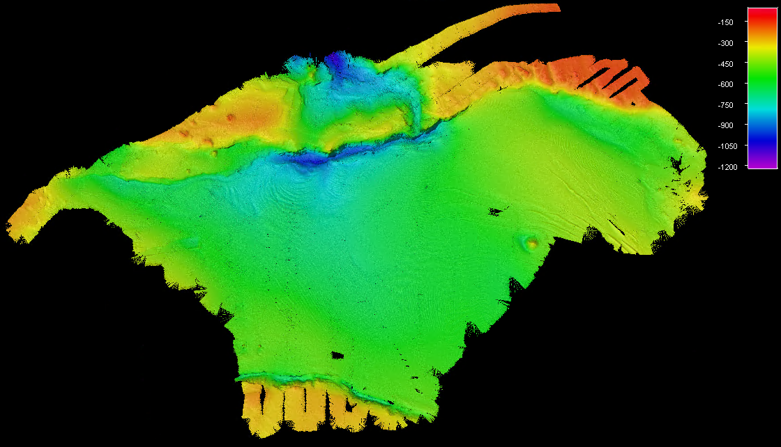
Screen capture from the Saildrone Surveyor’s onboard processing software of the unprocessed (raw) multibeam data collected in the Amukta Pass. Image courtesy of Saildrone. Download largest version (637 KB).
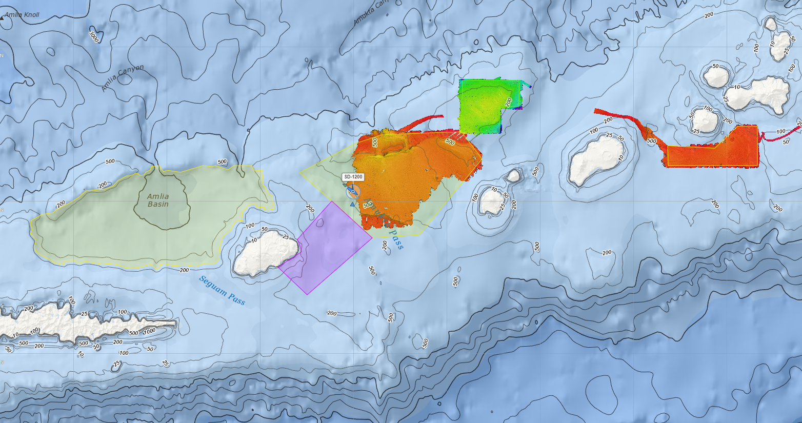
Polygons indicating some of the planned areas to be surveyed, with colored-in areas representing mapping data collected prior to the mid-project pit stop. Image courtesy of Saildrone. Download largest version (1 MB).
Published September 16, 2022
NOAA Ocean Exploration and the Bureau of Ocean Energy Management are the primary sponsors of the Aleutians Uncrewed Ocean Exploration expedition, which is being led by NOAA Ocean Exploration Cooperative Institute partners at the University of New Hampshire in active partnership with Saildrone and MBARI (Monterey Bay Aquarium Research Institute). Additional funding and support comes from the National Oceanographic Partnership Program, NOAA Research, NOAA’s Office of Coast Survey, NOAA’s Deep Sea Coral Research and Technology Program, and the U.S. Geological Survey. This project will support priorities highlighted in the National Strategy for Mapping, Exploring, and Characterizing the United States Exclusive Economic Zone.