
. Leg 2 operations focused on the Papahānaumokuākea Marine National Monument (white boundary). Leg 3 operations focused on the main Hawaiian Islands and Geologists Seamounts group.")
Summary map showing work conducted during four NOAA Ship Okeanos Explorer cruises as part of the EX-15-04 Hohonu Moana Expedition. During the course of three months, 65 days at sea were spent conducting mapping and 37 ROV dives in the Hawaiian Archipelago and offshore of Johnston Atoll. Leg 1 and 4 operations focused on the Johnston Atoll Unit of the Pacific Remote Islands Marine National Monument, now known as Pacific Islands Heritage Marine National Monument (blue boundary). Leg 2 operations focused on the Papahānaumokuākea Marine National Monument (white boundary). Leg 3 operations focused on the main Hawaiian Islands and Geologists Seamounts group. Image courtesy of the NOAA Office of Ocean Exploration and Research, 2015 Hohonu Moana. Download larger version (jpg, 1.5 MB).
After three months of operations, four cruise legs, 65 days at sea, and 37 remotely operated vehicle (ROV) dives, the 2015 Hohonu Moana: Exploring Deep Waters off Hawai’i expedition was brought to a close. This was an expedition of many firsts, including the first time NOAA Ship Okeanos Explorer conducted telepresence-enabled operations and engaged the ocean science community in the central Pacific region.
Thanks to the work of our partners at the University of Hawaii at Manoa and NOAA’s Inouye Regional Center, two new Exploration Command Centers were brought online and more than 75 scientists and students participated in the expedition from 14 U.S. states and four countries. Participants included graduate students from Harbor Branch Oceanographic Institute (HBOI) at Florida Atlantic University, who participated from the HBOI Exploration Command Center as part of an Ocean Exploration course – marking the first use of telepresence-based exploration in formal graduate curricula.
 fishery biologist Bruce Mundy gives background information about the expedition to visiting groups. Dr. Allen Andrews of PIFSC, at the upper left-center facing the audience, also gave talks to visiting groups about the biology of the deep-water corals and sponges seen during the expedition. Image courtesy of Ensign Nick Pawlenko, NOAA Commissioned Officer Corps.")
A new Exploration Command Center was brought online at NOAA’s Inouye Regional Center for the expedition. Here, NOAA Pacific Islands Fisheries Science Center (PIFSC) fishery biologist Bruce Mundy gives background information about the expedition to visiting groups. Dr. Allen Andrews of PIFSC, at the upper left-center facing the audience, also gave talks to visiting groups about the biology of the deep-water corals and sponges seen during the expedition. Image courtesy of Ensign Nick Pawlenko, NOAA Commissioned Officer Corps. Download image (jpg, 68 KB).

The University of Hawaii at Manoa brought an Exploration Command Center online this year to enable the participation of scientists and students from the University of Hawaii at Manoa and other universities in the area to participate in the Hohonu Moana Expedition via telepresence. Image courtesy of the NOAA Office of Ocean Exploration and Research, 2015 Hohonu Moana. Download larger version (jpg, 813 KB).
The expedition also marked the first time Okeanos Explorer collected physical samples with ROV Deep Discoverer. Limited rock samples were collected to provide more information about the origin and age of the seamounts and geologic features in the region. Biological sampling was limited only to potential new species or new animal records for the Hawai’i region and so all were surprised by the number of samples we collected – 70 – highlighting how much remains to be explored and discovered in our deep ocean.
 as it illuminates a ledge covered with a diverse assemblage of deep-sea corals and sponges. D2 displays its newly installed sample collection equipment – drawers, boxes, an advanced manipulator, and positionable illumination system – that have allowed us to do precision collections under direction of our science team leads.")
NOAA’s Seirios camera sled images the ROV Deep Discoverer (D2) as it illuminates a ledge covered with a diverse assemblage of deep-sea corals and sponges. D2 displays its newly installed sample collection equipment – drawers, boxes, an advanced manipulator, and positionable illumination system – that have allowed us to do precision collections under direction of our science team leads. Image courtesy of the NOAA Office of Ocean Exploration and Research, 2015 Hohonu Moana. Download image (jpg, 1.1 MB).
 Deep Discoverer places a piece of an unknown Corallium species collected at 2,078 meters depth in one of the bio boxes on the ROV.")
Remotely operated vehicle (ROV) Deep Discoverer places a piece of an unknown Corallium species collected at 2,078 meters depth in one of the bio boxes on the ROV. Image courtesy of the NOAA Office of Ocean Exploration and Research, 2015 Hohonu Moana. Download larger version (jpg, 1.2 MB).

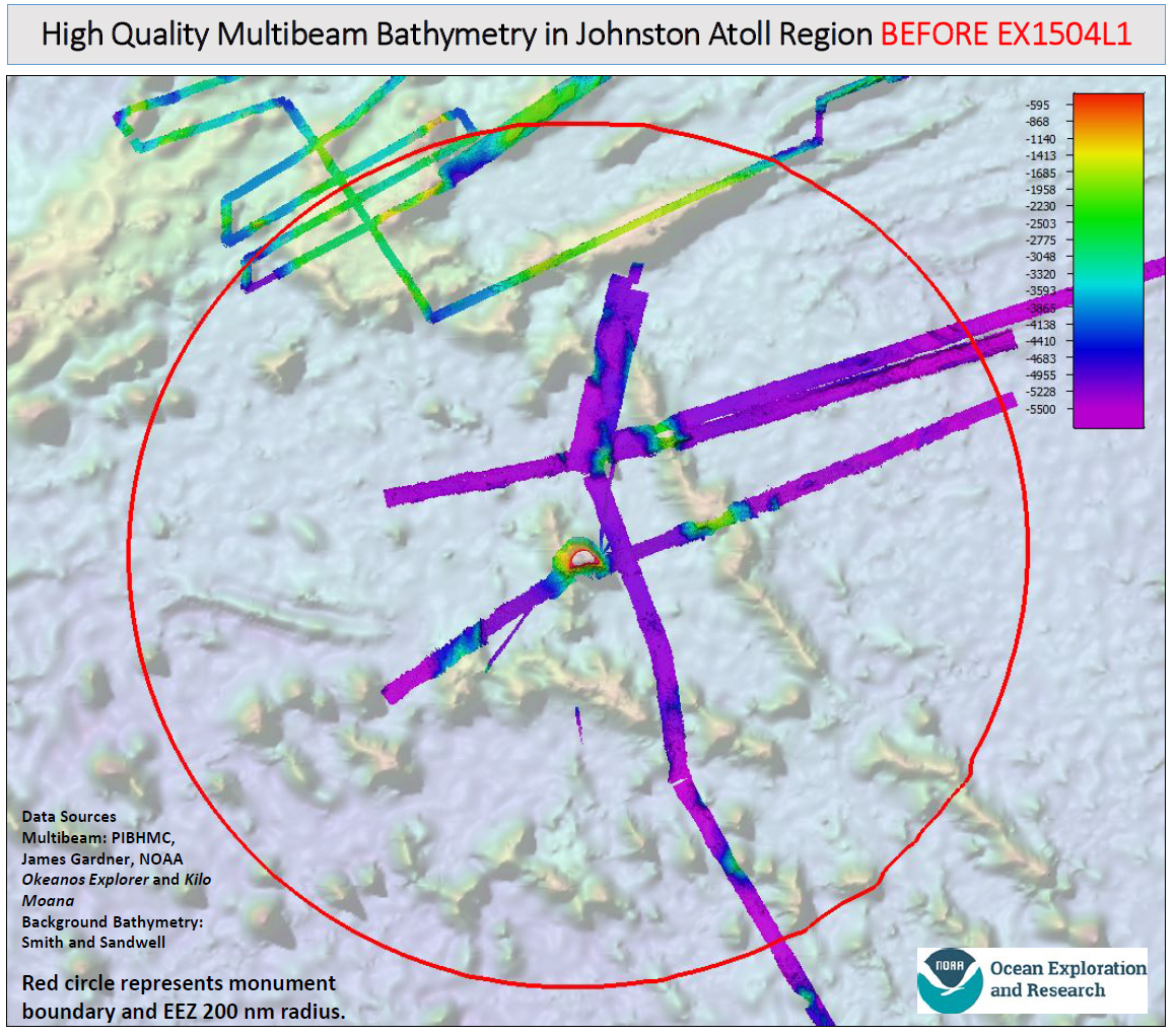
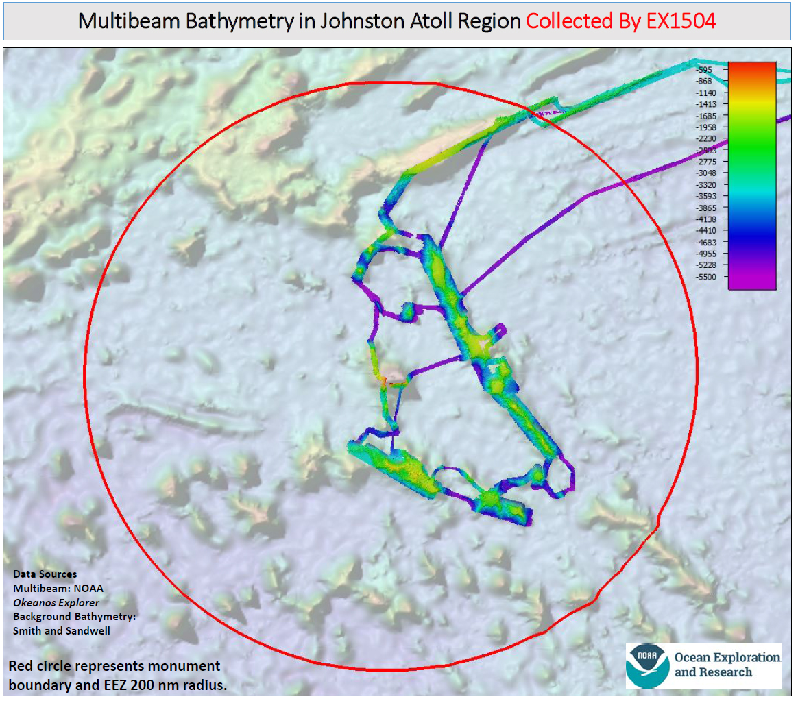
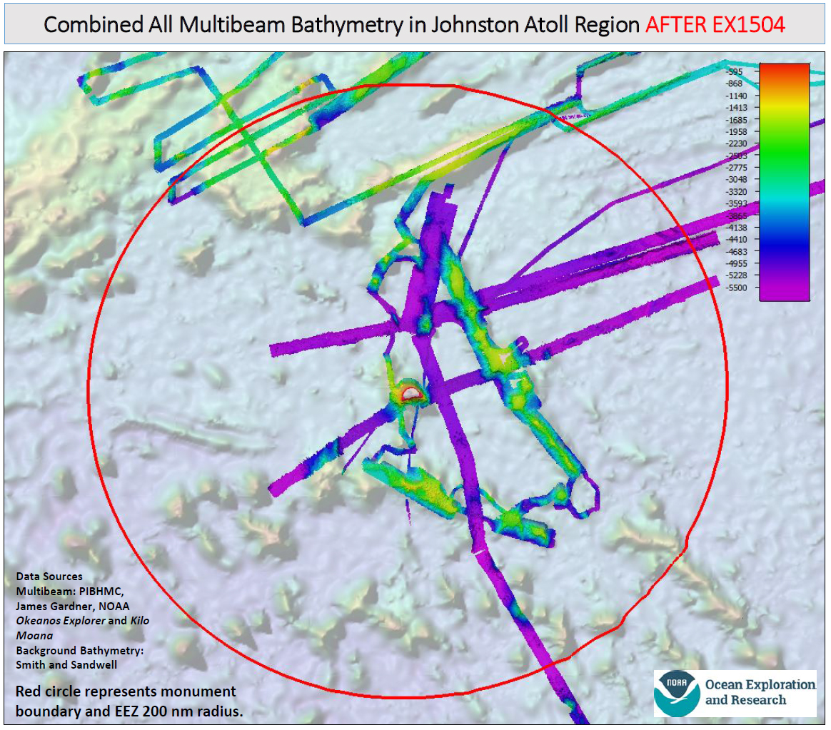
Maps showing the multibeam sonar mapping coverage in the Johnston Atoll Unit of the Pacific Remote Islands Marine National Monument, now known as Pacific Islands Heritage Marine National Monument before and after Legs 1 and 4 of the 2015 Hohonu Moana Expedition with NOAA Ship Okeanos Explorer. Image courtesy of the NOAA Office of Ocean Exploration and Research, 2015 Hohonu Moana.
Download larger version of map showing data coverage before the expedition (jpg, 827 KB).
Download larger version of map showing data collected during expedition (jpg, 769 KB).
Download larger version of map showing composite data coverage after the expedition (jpg, 896 KB).
The first and fourth cruise of the expedition focused on mapping and characterizing the recently expanded Johnston Atoll Unit of the Pacific Remote Islands Marine National Monument (PRIMNM). Previous to the Monument’s expansion, no ROV or submersible dives had been conducted deeper than 366 meters. When the PRIMNM boundaries were extended out to the U.S. Exclusive Economic Zone in 2014, they encompassed an area of the Horizon Tablemount where 10 submersible dives were conducted in 1987 using the Alvin submersible; however, the vast majority of the Monument remains largely unexplored.
Mapping operations were conducted on both cruise legs to collect high-resolution multibeam, single beam, and sub-bottom profiler data over the Horizon Tablemount, Karin Ridge, and Johnston Seamount group. Preliminary observations from the mapping data revealed that the seafloor terrain on the seamounts and guyots within the Monument is complex and fascinating. There are many flat-topped seamounts (guyots) which were likely above sea level at some point in time, and a subset of those are dotted with what appear to be volcanic domes that likely formed during a different period.
Eleven ROV dives were conducted at the Johnston and Karin seamount chains, including the first seafloor visual surveys of the Cretaceous guyots within the Monument and the deep-water volcanic cones on the Johnston Seamounts.
Two ROV dives were conducted to support other NOAA interests in the Main Hawaiian Islands during transit to and from the Monument, including a dive in an area under consideration for inclusion in the Hawaiian Islands Humpback Whale National Marine Sanctuary and a dive to recover previously deployed instruments (see Main Hawaiian Islands section below).
Several highly diverse and abundant coral and sponge gardens were discovered at depths greater than 1,800 meters during these dives, and potentially 180 different types of animals were observed during the Johnston Atoll Unit dives, including 30 that are thought to be potential new species or records for the region. Specimens of these species were collected for further analysis, along with 26 rock samples that will be analyzed to provide more information about the origin and age of the seamounts and geologic features.
 species in the anomuran family Chirostylidae. This squat lobster was seen a few times during the expedition but escaped all collection attempts.")
This distinctive-looking, spiny squat lobster, seen here perched on a black coral, Umbellapathes, at 1,493 meters depth in the Johnston Atoll Unit of the PRIMNM, is likely a new (undescribed) species in the anomuran family Chirostylidae. This squat lobster was seen a few times during the expedition but escaped all collection attempts. Image courtesy of the NOAA Office of Ocean Exploration and Research, 2015 Hohonu Moana. Download larger version (jpg, 1.3 MB).
. This fish is rarely encountered - the whole genus is known from a collection of fewer than 20 individuals. This species was previously known only from the eastern tropical Pacific. Although the eye is large, we don't think they can actually see images, as the eye does not have a fully-formed lens.")
The cusk eel, Leucicorus lusciosus (Garman, 1899). This fish is rarely encountered - the whole genus is known from a collection of fewer than 20 individuals. This species was previously known only from the eastern tropical Pacific. Although the eye is large, we don't think they can actually see images, as the eye does not have a fully formed lens. Image courtesy of the NOAA Office of Ocean Exploration and Research, 2015 Hohonu Moana. Download larger version (jpg, 1.2 MB).
The second cruise of the expedition focused on conducting ROV surveys on priority areas identified from 2014 R/V Falkor mapping data in the Papahānaumokuākea Marine National Monument (PMNM). Although considerable previous work had been conducted down to 2,000 meters with submersibles, the majority of habitat in PMNM is below 2,000 meters and as a result had never been surveyed before.
Specimen of Corallium species collected from a large high-density deep-sea coral and sponge community encountered on the ridge crest of Pioneer Bank. An ROV dive here during the cruise revealed that a known high-density community further upslope extended at least six kilometers down the ridge to where the dive was conducted. Image courtesy of the NOAA Office of Ocean Exploration and Research, 2015 Hohonu Moana. Download larger version (jpg, 1.5 MB).
ROV dives were conducted from West Nihoa to Salmon Bank and focused on conducting seafloor surveys of rift zone ridges and other types of abrupt topography likely to host high-density communities of deep-water corals and sponges. A total of 18 dives were conducted from 1,096 meters to 4,829 meters, including the deepest dives ever conducted in PMNM. Two ROV dives extended the depth range of known high-density communities of coral and sponges, and six discovered new ones. Two dives included mid-water transects to document animals living in the little known water column from 450 meters to 1,200 meters.
Overall, 334 different types of animals were identified from visual surveys of the seafloor and water column, including cnidarians, sponges, echinoderms, arthropods, mollusks, tunicates, bryozoans, ctenophores, siphonophores, fishes, and a squid. Of these, 35 were identified as potential new species or records for the region and were collected for further analysis. Additionally, 31 rock samples were collected to provide more information about the origin and age of the seamounts and geologic features of the Northwestern Hawaiian Islands.
When the ROV was not in the water, the team conducted mapping operations. During the 24-day cruise, more than 29,000 square kilometers of seafloor were mapped, including three seamounts in PMNM that were not previously mapped using multibeam sonar. This area is equivalent to nearly twice the size of the landmass of all of the Hawaiian Islands combined! Aside from transit to and from PMNM, all of the work conducted during the cruise was either inside the Monument or in support of Monument interests.

ROV Deep Discoverer recovers a current meter at a dive site just south of Oahu. Image courtesy of the NOAA Office of Ocean Exploration and Research, 2015 Hohonu Moana. Download larger version (jpg, 1.1 MB).
The third cruise of the expedition was a short seven-day contract cruise funded entirely by NOAA’s Deep Sea Coral, Research and Technology Program (DSCRTP). As such, several of the dives were conducted to meet specific DSCRTP program objectives and used a different operating mode than Okeanos Explorer’s typical community-driven exploration mode.
Two of three planned dives were conducted to retrieve instruments deployed in previous years that were collecting data on the environmental conditions of precious coral beds located offshore of Oahu and the Big Island of Hawai’i. These instruments included an acoustic current meter that provides current direction, flow rate, and an optic sensor for particle load, and a number of simpler flow meters that monitor the speed of the passing water. The instruments were successfully retrieved and the data is being downloaded for further analysis. Previously marked corals being overtaken by gold coral colonies were also examined during the dives.
One of these instrument recovery dives visited the hull of the World War I-era submarine, S-19. The vessel was intentionally scuttled by the Navy in 1938 and now serves as a relatively new feature of hard bottom habitat (~ 75 years old) for deep corals to colonize. A complete survey of the full deck area of the S-19 hull was conducted with attention to the deep coral community growing on it and looking for any evidence of recent arrival of the parasitic gold coral. Observations on the condition of the S-19 itself indicate the submarine is relatively intact, aside from features removed prior to disposal, and is resting on its midship section.

A dive during Leg 3 of the expedition visited the S-19 submarine to assess the state of the submarine and survey the settlement of a pioneer coral community covering the sub. Image courtesy of the NOAA Office of Ocean Exploration and Research, 2015 Hohonu Moana. Download larger version (jpg, 1.6 MB).

Sketch of the S-19 submarine by NOAA Maritime Archaeologist, Hans Van Tilburg, following an ROV dive on the site. Observations on the condition of the S-19 itself indicate the submarine is relatively intact, aside from features removed prior to disposal, and is resting on its midship section. Image courtesy of Hans Van Tilburg, NOAA. Download larger version (jpg, 323 KB).
Another dive on this cruise was conducted to support a study on disturbance and recovery of precious corals near South Point, Hawai’i, being conducted by Sam Kahng and Meagan Putts of Hawai’i Pacific University. In Hawai’i, lava flows on the Big Island provide a unique opportunity to examine the development of these coral communities across time. Each lava flow represents a severe disturbance event that marks the birth of a new coral community in the area where the flow occurred while inhabited areas to either side of the new flow are left undisturbed. The known dates of lava flows allow for examination of the development of these coral communities across time. A two-kilometer long transect was conducted at a consistent depth of 450 meters, applying the same survey method as conducted in previous years to extend the survey area and collect as much ecological data as possible for later analysis. This was the longest single transect conducted by the Deep Discoverer in a single dive.

Image of a high-density coral community encountered on the ridge crest of Swordfish Seamount at ~1,000 meters depth. Located in the Geologists Seamounts group, this was the first ROV dive ever conducted on Swordfish Seamount. Image courtesy of the NOAA Office of Ocean Exploration and Research, 2015 Hohonu Moana. Download larger version (jpg, 1.4 MB).
Finally, three dives were conducted in Okeanos Explorer’s typical community-driven exploration mode and were the first visual surveys conducted of McCall, Swordfish, and Ellis seamounts within the Geologists Seamounts group. High-density coral communities were found at Ellis and Swordfish seamounts, while a low density of corals were observed on the McCall Seamount dive. Some interesting geological observations were made on the Geologists Seamounts, leaving the geologists on our team with more questions than answers.
During the six dives conducted on this cruise, the science team observed at least 189 types of animals, including 16 that are potential new species or records for the region (this includes two species that were also recorded during the previous cruise leg). A number of these organisms were collected for further analysis, along with 11 rock samples that will be analyzed to provide more information about the origin and age of the seamounts, lava flows, and geologic features investigated during this cruise.
All of the ROV dives and most of the mapping operations conducted during the expedition met the primary expedition objectives of acquiring data to support priority science and management needs in the region, especially focused on two marine national monuments. Nearly all of these data will be made publically accessible in the coming months, providing a foundation of publicly accessible data and information products to spur further exploration, research, and management activities for years to come.
Perhaps most exciting is that the expedition was not limited to the operations and science team. Online coverage of the expedition, including live video feeds, were streamed to shore throughout, allowing thousands of the public to join our dives and virtually explore the ocean with us. Live video from the expedition received ~575,000 views, for a total view time of 68,890 hours of live ocean exploration footage, and the expedition web pages received another 150,000 views.
Expedition information and observations were shared through social media venues including Facebook and Twitter. The NOAA Office of Ocean Exploration and Research (OER) Twitter account gained over 3,500 new followers, and expedition tweets reached over 830,000 users. OER’s Facebook account gained over 6,300 new likes during the expedition, and posts reached over 1.6 million Facebook users.
The expedition team is truly honored to be able to engage so many of the public in real-time ocean exploration
Although the 2015 Hohonu Moana: Exploring Deep Waters off Hawai’i expedition is now over, the three-year ‘Campaign to Address Pacific monument Science, Technology, and Ocean NEeds (CAPSTONE)’ effort has just begun.
Join us next year as NOAA Ship Okeanos Explorer continues exploring deep-water U.S. marine protected areas in the central and western Pacific.


