By Daniel Wagner, Ph.D., NOAA Papahānaumokuākea Marine National Monument
March 9, 2016

Photograph of new species of squat lobster sitting on a new species of black coral taken by the Okeanos Explorer ROVs during the 2015 expedition to the Monument. Image courtesy of the NOAA Office of Ocean Exploration and Research, Hohonu Moana 2015. Download larger version (466 KB).
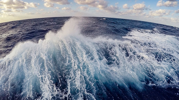
The current expedition aboard NOAA Ship Okeanos Explorer has been particularly exciting, because it represents the third successive year that I have returned to the Northwestern Hawaiian Islands to explore the deep waters of this unique region. During each one of these successive visits, we have been able to build on knowledge acquired during the previous expedition. As a result, we have been able to explore this area in a systematic manner and uncover some of the unique features that have remained hidden in the deep waters of Papahānaumokuākea Marine National Monument.
The journey started over three years ago, when we got together with a group of scientists from Hawaii and elsewhere to attempt what seemed like an overwhelmingly ambitious goal: to map the entire seafloor of the Papahānaumokuākea Marine National Monument, one of the largest marine protected areas on Earth. This goal seemed particularly daunting because at the time, less than half of the 362,000 square kilometers of the Monument had been mapped.
Motivated by this ambitious goal, in 2014 we sailed to the Northwestern Hawaiian Islands aboard the R/V Falkor operated by the Schmidt Ocean Institute. Over the course of 72 days, we mapped over 127,000 square kilometers in the Northwestern Hawaiian Islands, including nine seamounts that had not been previously mapped.
In addition to creating mapping data for a large portion of the Monument, the voyages by the R/V Falkor provided the first high-resolution maps for some spectacular underwater mountains, or seamounts. While these high-resolution maps provided some clues of what might be found on these seamounts, many of us were eager to deploy underwater vehicles and get a first look on what might be found there. Thus, we were particularly delighted to find out that NOAA Ship Okeanos Explorer would be coming to the Pacific and spend three years exploring the deep water of the region with its state-of-the-art ROVs. We were so excited about finally getting a chance to dive on the seamounts that we had just mapped the year before. I was counting down the days to finally get to see the seafloor on these places for the very first time.

Map of Academician Berg and Turnif Seamount created by high-resolution mapping data collected during the 2014 expedition to the Monument aboard the R/V Falkor. Image courtesy of Christopher Kelley, University of Hawaii. Download larger version (jpg, 538 KB).

R/V Falkor docked at Honolulu prior to mapping expedition to the Papahānaumokuākea Marine National Monument in 2014. Image courtesy of Daniel Wagner, NOAA. Download larger version (jpg, 578 KB).
In the summer of 2015, I finally boarded the Okeanos Explorer on a 24-day mission to the Papahānaumokuākea Marine National Monument, during which we dove on many of these completely unexplored seamounts. Those dives exceeded my greatest expectations, as the high-definition images captured by the remotely operated vehicles (ROVs) showed places full of life—in many cases, full of life that was new to science.

NOAA Ship Okeanos Explorer docked at Pearl Harbor prior to expedition to the Northwestern Hawaiian Islands in 2015. Image courtesy of Arthur Howard, NOAA. Download larger version (818 KB).
Over the course of three weeks, we conducted 18 ROV dives and imaged hundreds of species that were either new to science or not known to exist in Hawaii. Furthermore, we collected a total of 36 biological specimens, all of which ended up being completely new species or species we did not know existed in Hawaii.
In addition to the ROV dives, we mapped an additional 29,000 kilometers over the course of the expedition, including three brand new seamounts that had eluded our previous mapping efforts.
Despite the many findings we made on the Okeanos Explorer in 2015, I knew that we had really only scratched the surface, as the great amount of new discoveries suggested that the Monument was still largely unexplored. I was therefore thrilled to learn that the Okeanos Explorer would return to the Papahānaumokuākea Marine National Monument in 2016 to follow up on the work we started here last year.

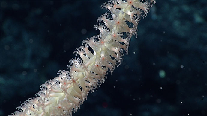
ROV Deep Discoverer imaging a high-density community that included several species that are likely new to science during the 2016 expedition to the Monument. Image courtesy of the NOAA Office of Ocean Exploration and Research, Hohonu Moana 2016. Download larger version (241 KB).
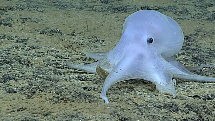
Excited, I boarded the Okeanos Explorer two weeks ago to come back to this place that seemed to harbor an endless amount of secrets. Thus far, we have once again made some remarkable discoveries, as we have imaged a myriad of species which we believe are new, including a mysterious octopus that has captivated both scientists and the general public. Additionally, we have spent some more time mapping areas that had not been previously charted, and in the process have come across four additional seamounts which are completely new.
Each one of these three successive visits to Papahānaumokuākea has been unique and rewarding in countless ways, as these voyages have revealed that the waters of the region are even more vast and full of secrets that we imagined. While it will take a long time to make sense of the great amount of data that we have collected during these three expeditions, I hope to be able to come back to this unique region and uncover more of its many secrets.