By Matt Jackson, Department of Earth Science, University of California Santa Barbara
In much the same way that plumes rise buoyantly in a lava lamp, plumes of hot mantle rock are thought to rise buoyantly from the deep mantle, originating at depths as deep as the boundary between the core and mantle (which is approximately 2,900 kilometers beneath the Earth’s surface). When a plume rises to the shallow mantle, it partially melts and the melt upwells to the surface and erupts at a hotspot volcano.
As a mantle plume upwells quasi-vertically and melts, the tectonic plate (beneath which the plumes upwell) moves laterally. As a result, a linear chain of hotspot volcanoes forms on the overriding tectonic plate and extends “downstream” of the upwelling mantle plume. The youngest, most active volcanoes are situated directly over the upwelling mantle plume, a location referred to as a "hotspot." Progressively older (extinct) volcanoes populate the surface of the tectonic plate downstream of the hotspot, in the direction of plate motion.

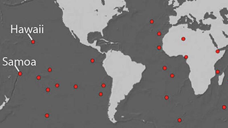
Figure 1. The global distribution of volcanic hotspots that are fed by upwelling mantle plumes, shown in red. The Hawaiian and Samoan hotspots are identified for reference. Figure made with assistance from Drew Reinhard; from French, S. W. & Romanowicz, B. Broad plumes rooted at the base of the Earth's mantle beneath major hotspots. Nature 525, 95–99 (2015). Download image (jpg, 20 KB).

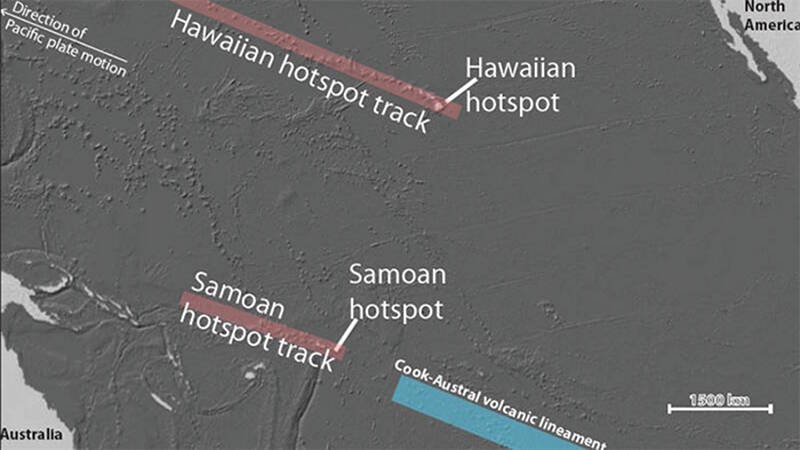
Figure 2. The Samoan and Hawaiian hotspots and their associated hotspot tracks. The Cook-Austral volcanic lineament is shown for reference. Figure made with assistance from Drew Reinhard. Download image (jpg, 42 KB).
At least 28 plume-fed volcanic hotspots are suggested to exist on the Earth’s surface (Figure 1). Two famous examples of plume-fed volcanic hotspots are Hawaii and Samoa. Both Hawaii and Samoa are composed of linear chains of volcanic islands situated atop the Pacific tectonic plate (Figure 2).
Because the Pacific plate is moving slowly (at about the same rate your fingernails grow) to the west-northwest, both volcanic hotspot tracks have age-progressive volcanic chains that extend toward the west-northwest; the volcanoes furthest to the west are the oldest, and the volcanoes furthest to the east are the youngest. Both Hawaii and Samoa have young, active volcanoes that define the location of the respective volcanic hotspot. These two hotspot volcanoes are so young that they are still just seamounts, but with continued volcanism, they will eventually grown to a size where they breach the ocean's surface and become islands.
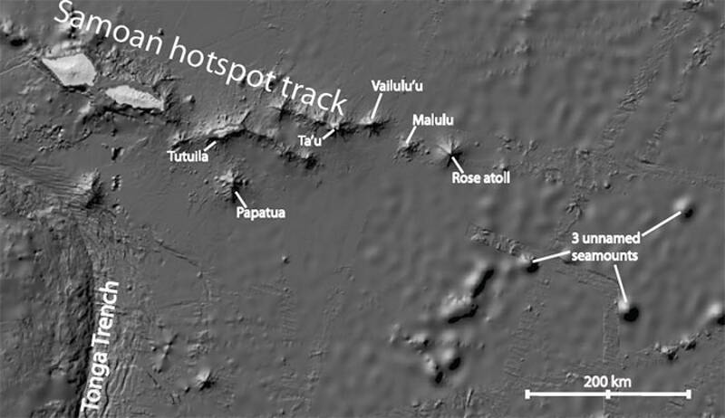
At Samoa, the young, active hotspot volcano has been named Vailulu’u (Figure 1). This volcano is undergoing rapid growth: over a period between 1999 and 2005, a volcanic cone, called Nafanua, rose 300 meters from the crater of Vailulu’u. An important goal of the expedition aboard the Okeanos Explorer will be to investigate new growth of the Nafanua volcanic cone and to find evidence for hydrothermal activity and marine life that may populate this new volcanic feature.
Older, extinct Samoan volcanoes located to the west of Vailulu’u will also be explored during the Okeanos Explorer expedition. The volcanic island of Ta’u, located just over 30 kilometers west of Vailulu’u seamount, will also be targeted. A remotely operated vehicle dive on Ta'u will focus on a buttressing ridge extending underwater to the southwest of the island. This region of the submarine flanks of Ta’u has never been sampled and may provide insights into the earlier stages of volcanism at this island.
Approximately 140 kilometers west of Ta’u, the deep submarine flanks of the volcanic island of Tutuila will also be targeted. It is thought that a Samoan volcano experiences dramatic chemical evolution over the course of its lifetime, and the lavas that outcrop on the deepest flanks of Tutuila may provide new insights into the earliest stages of volcanism—and possible new, extreme lava compositions—on this island.

Figure 3. The islands and seamounts of the Samoan region. Island and seamount targets for geological sampling by remotely operated vehicle are identified: Vailulu’u, Ta’u, Malulu, Rose, Papatua, Tutuila, and three unnamed/unexplored seamounts located in the eastern Samoan region. The Tonga Trench is shown for reference. Figure made with assistance from Drew Reinhard. Download image (jpg, 47 KB).
Papatua seamount is located just 50 kilometers south of Tutuila, but its genetic relationship with the Samoan hotspot is unclear. Two prior expeditions to Papatua recovered lavas with very different ages. Fresh lavas with glassy rinds were recovered on the northern flanks of the seamount on an earlier expedition, and a later expedition targeting the southern portion of the seamount discovered old lavas with thick ferromanganese crusts and geochemical signatures that are inconsistent with an origin at the Samoan hotspot. It is thought that the older samples provide information about the early, shield-stage of volcanism at Papatua, and the young and fresh samples provide information about a more recent, rejuvenated stage of volcanism at the seamount.
This expedition will target the shallowest portions of the seamount and may result in recovery of additional rock material that may capture the rejuvenated stage of volcanism. These new samples will provide important information about the rejuvenated stage of volcanism and whether it has chemical fingerprints that link it to the Samoan hotspot.
Finally, the Okeanos Explorer expedition will target one atoll and four seamounts located to the east of Vailulu’u. Because these five volcanic features are located to the east of the Samoan hotspot, they are unlikely to be related to melting of the upwelling Samoan plume. However, there are three volcanic hotspots in the Cook-Austral volcanic lineament that have been active for tens of millions of years. These three hotspots are situated approximately 1,000 and 3,000 kilometers to the east-southeast of the Samoan hotspot. Therefore, it is possible that extinct volcanoes related to the older portions of these hotspots may now reside in the region just to the east of the Samoan hotspot.
One hypothesis is that five volcanic features east of Vailulu’u seamount—Rose Atoll, Malulu seamount, and three unexplored and unnamed seamounts—may be ancient volcanic edifices that were generated over one of the three volcanic hotspots in the Cook-Austral region. Lavas associated with the three volcanoes in the Cook-Austral region are chemically distinct from the lavas in the Samoan hotspot, and the volcanoes associated with the Cook-Austral volcanic lineament will also have a distinct range of ages that greatly exceed the ages of Samoan lavas in the region by 10 to 30 million years. Thus, the volcanic rocks obtained from the five volcanic edifices east of Vailulu’u will allow us to determine whether these "interlopers" in the Samoan region are actually related to hotspots in the Cook-Austral region.