by Kelley Elliott, Expedition Manager, NOAA Office of Ocean Exploration and Research
Dr. Christopher Kelley, CAPSTONE Science Advisor/ Biology Co-Lead, University of Hawaii at Manoa
Dr. Christopher Mah, National Museum of Natural History, Smithsonian Institution
Mashkoor Malik, Mapping Lead, NOAA Office of Ocean Exploration and Research
July 7 - August 2, 2017

Map showing the general cruise plan for the Johnston Atoll exploration portion of the expedition. The white line is the general cruise track, and the orange dots are the locations of planned ROV dives, numbered in planned dive site order. The green boxes are the locations for targeted overnight mapping operations. Image courtesy of the NOAA Office of Ocean Exploration and Research, 2017 Laulima O Ka Moana. Download larger version (jpg, 816 KB).
From July 7 to August 2, 2017, NOAA and partners will conduct a telepresence-enabled ocean exploration expedition on NOAA Ship Okeanos Explorer to collect critical baseline information about unknown and poorly known deepwater areas near Johnston Atoll. Like previous expeditions, NOAA will work with the scientific and resource management communities to characterize these areas through telepresence-based exploration. Operations will use the ship’s deepwater mapping systems, NOAA’s dual-bodied 6,000-meter remotely operated vehicle (ROV) Deep Discoverer (D2) and Seirios, as well as a high-bandwidth satellite connection for real-time ship-to-shore communications.
The 27-day expedition is divided into two parts: the first four days of the cruise will be dedicated to shakedown operations (field tests of ship systems following a repair period) in the vicinity of Oahu, and the latter weeks will focus operations on transit to and from the Johnston Atoll Unit (JAU) of the Pacific Remote Islands Marine National Monument (PRIMNM), now known as Pacific Islands Heritage Marine National Monument, where the ship will spend the majority of the expedition conducting daily daytime ROV dives and overnight mapping operations.
ROV dives are planned to survey seamounts and deep-sea coral and sponge habitats and will include high-resolution visual surveys and limited sampling. Live video of dives in the Johnston Atoll Unit can be viewed online in real-time from July 13 or 14 to 29, 2017, typically from about 8 am to 5 pm HST.

Established in January 2009 by Presidential Proclamation 8336 and expanded in 2014 by Presidential Proclamation 9173, the Pacific Remote Islands Marine National Monument, now known as Pacific Islands Heritage Marine National Monument, consists of Wake, Baker, Howland, and Jarvis Islands; Johnston Atoll; Kingman Reef; and Palmyra Atoll, which all lie to the south and west of Hawaii. The Pacific Remote Islands Marine National Monument is one of the largest marine protected areas in the world and an important part of the most widespread collection of marine life on the planet under a single country's jurisdiction. Image courtesy of the NOAA National Marine Fisheries Service. Download larger version (jpg, 489 KB).
This expedition is part of a three-year Campaign to Address Pacific monument Science, Technology, and Ocean Needs (CAPSTONE), a major multi-year foundational science initiative to collect deepwater baseline information to support science and management decisions in and around U.S. marine protected areas in the central and western Pacific. CAPSTONE serves as an opportunity for NOAA and the nation to highlight the uniqueness and importance of these areas.
The central and western Pacific monuments and sanctuaries encompass over one million square miles of emergent land, coral reef, ocean, and maritime heritage resources, as well as harbor numerous protected species and likely an abundance of undiscovered resources. Yet most deepwater areas remain poorly known even though they are of high interest to federal and state agencies with research and management responsibilities. To address this challenge, CAPSTONE has involved a series of expeditions conducted from the NOAA Ship Okeanos Explorer and its deepwater vehicles and instrumentation.
More than 99 percent of the Johnston Atoll Unit (JAU) of the PRIMNM is deep water and despite some previous work, much remains unknown. Increasing baseline knowledge of ocean habitats is critical to the conservation of these remarkable ecosystems. Exploratory missions, such as those conducted via Okeanos Explorer, are necessary to expand our knowledge of the unknown and to provide baseline data for resource managers.
Some interesting questions about JAU are provided in one of the background essays and include how “connected” this remote atoll is to the Hawaiian Archipelago, whether it served as a gateway to species colonizing Hawaiian waters from further west, and whether the clear differences in the depth of the Oxygen Minimum Zones (OMZ) in JAU and Hawaii are reflected in differences in the composition of the communities at these two locations.

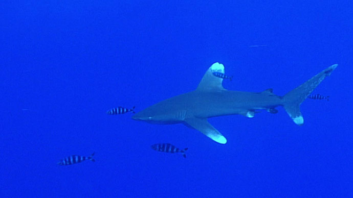
Several large deepwater corals grow in a high-density community. Image courtesy of the NOAA Office of Ocean Exploration and Research. Download larger version (jpg, 217 KB).
The 2017 Laulima O Ka Moana expedition will address science themes and priority areas put forward by scientists and managers from NOAA, management agencies in the region, and the ocean science community. Operations are planned to leverage and complement previous work in the area. NOAA priorities for the expedition include a combination of science, education, outreach, and open data objectives that will support management decisions at multiple levels:
. The green boxes are areas where we plan to conduct focused mapping operations during the expedition.")
Map showing expedition cruise plans with previous work in the region. The red dots are the locations where previous dives have been conducted using an ROV or submersible, and the orange dots are the locations of planned ROV dive sites for this expedition. The multicolored areas show publicly-available bathymetry data, color-coded by depth (yellow to purple showing shallow to deep). The green boxes are areas where we plan to conduct focused mapping operations during the expedition. Image courtesy of the NOAA Office of Ocean Exploration and Research, 2017 Laulima O Ka Moana. Download larger version (jpg, 1.2 MB).
Exploration of deep-sea habitats offshore of Johnston Atoll was conducted in the 1980s, before the 2009 establishment of PRIMNM, when the Atoll was a National Wildlife Refuge. Several dozen dives as deep as 366 meters were conducted around Johnston Atoll in 1983 using the Hawaii Undersea Research Laboratory’s Makali’i submersible to investigate fisheries resources and macroalgal habitats and conduct oceanographic studies to support the U.S. Army’s Johnston Atoll Chemical Agent Disposal System (JACADS) effort. In 1987, 10 submersible dives were conducted on Horizon Tablemount to investigate sediment transport processes and the geochemical behavior of sediment on seamounts by U.S. Geological Survey using the National Deep Submergence Facility’s Alvin submersible.
Following the 2009 establishment and 2014 expansion of the Johnston Atoll Unit of PRIMNM, NOAA and partners initiated exploration of JAU’s deepwater habitats in 2015 as part of the Hohonu Moana expedition – the first expedition in the CAPSTONE series. Eleven ROV dives explored seafloor and water column habitats in the Johnston and Karin (Sculpin) seamount chains. Mapping operations acquired high-resolution sonar data over the Horizon Tablemount, Karin Ridge, and Johnston Seamount group.
In January 2017, the Schmidt Ocean Institute’s R/V Falkor added to this coverage by mapping six more seamounts in the Johnston Seamount Group. In July 2017, NOAA and partners will continue the effort to explore and better understand the deep-sea habitats and resources within JAU, diving on many seamounts for the first time, including several mapped by Falkor earlier this year.

NOAA Ship Okeanos Explorer uses telepresence technology to transmit data in real time to a shore-based hub where the video is then transmitted to a number of Exploration Command Centers located around the country as well as to any Internet-enabled device. Access to the video combined with a suite of Internet-based collaboration tools allow scientists on shore to join the operation in real time and allows the general public to follow the expedition online. Image courtesy of the NOAA Office of Ocean Exploration and Research. Download larger version (jpg, 1.1 MB).
The majority of scientists participate in NOAA Ship Okeanos Explorer expeditions from shore using telepresence technology. Live high-definition video feeds and data are sent via satellite to shore where they are available on both standard Internet and Internet-2 pathways. Shore-based scientists view these live video feeds and interact with the ship and other scientists through a teleconference line and Internet-based collaboration tools. Using these communication tools, the scientists and students can contribute expertise and help guide the at-sea operations in real time, extending the reach of ocean exploration to more scientists and students than could possibly be accommodated onboard the ship. At the same time, the public can follow along by watching the live video feeds online.
Some scientists participate from Exploration Command Centers (ECCs) that have been set up around the country. These ECCs are Internet-2 enabled and equipped with multiple large-screen monitors and a teleconference capability – providing easy access to all three high-definition video feeds with the lowest latency (less than two seconds from the ship) and fostering collaboration and learning among other participating scientists and students. A number of ECCs will be online for the expedition, including: the University of Hawaii at Manoa and NOAA's Inouye Regional Center in Hawaii; NOAA Headquarters in Maryland; Harbor Branch Oceanographic Institution in Florida; Inner Space Center at the University of Rhode Island; Stennis Space Center in Mississippi; University of New Hampshire; and the Pacific Marine Environmental Laboratory in Washington and Oregon.
Scientists are also expected to participate from a number of other remote locations around the country and world. These scientists, and others on call if a discovery is made at sea, will contribute their expertise in real time to operations at sea.
This expedition provides extensive opportunities for the public to connect to the mission. The live video feeds are available to anyone online, providing the public with a front row seat to exploration activities and discoveries as they are made.
Web content developed for this expedition includes background content; mission logs; daily updates; videos and images; and a live video feed. Education materials allow educators and students to engage their classrooms using products tied to the expedition, including standards-based lesson plans, background information, ocean career connections, links to previous Office of Ocean Exploration and Research-sponsored expeditions, and more.