The essays below will help you to understand the goals and objectives of the mission and provide additional context and information about the places being explored and the science, tools, and technologies being used.
July 7 - August 2, 2017 | By Kelley Elliott, Christopher Kelley, Christopher Mah, and Mashkoor Malik

From July 7 to August 2, 2017, NOAA and partners will conduct a telepresence-enabled ocean exploration expedition on NOAA Ship Okeanos Explorer to collect critical baseline information about unknown and poorly known deepwater areas near Johnston Atoll. Like previous expeditions, NOAA will work with the scientific and resource management communities to characterize these areas through telepresence-based exploration. Operations will use the ship’s deepwater mapping systems, NOAA’s dual-bodied 6,000-meter remotely operated vehicle (ROV) Deep Discoverer (D2) and Seirios, as well as a high-bandwidth satellite connection for real-time ship-to-shore communications.
Read moreBy Christopher Mah

This NOAA Ship Okeanos Explorer expedition to the Johnston Atoll Unit of the Pacific Remote Islands Marine National Monument, now known as Pacific Islands Heritage Marine National Monument, will potentially provide information relevant to a number of interesting biological questions that are currently being asked by both shallow water and deepwater researchers working in this area of the Pacific. Johnston Atoll is located approximately 700 miles southwest of the Hawaiian Islands. Its proximity begs a series of important questions, outlined in this essay.
Read moreBy Jasper Konter

The central Pacific Ocean basin contains only a few islands, and they are spaced apart over large distances. These islands generally were built as volcanoes on the Pacific Ocean floor, growing from three miles deep to the ocean surface or further. Some of these islands are geologically young, such as the Hawaiian Islands, and include features such as volcanic craters and cones.
Read moreBy Christopher Kelley
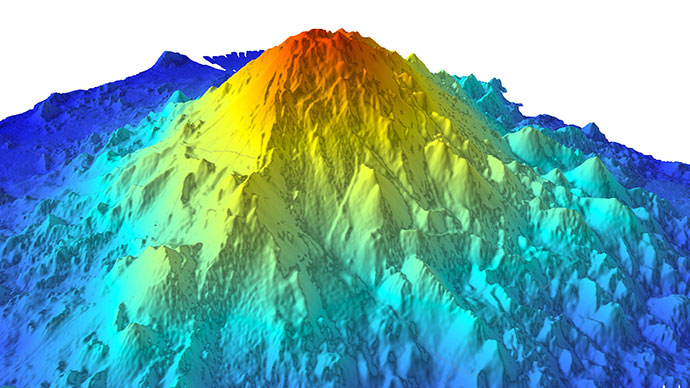
 and guyot (right), showing the difference in the summit morphology.")
Seamounts are volcanic constructs that protrude from the expansive and relatively monotonous abyssal seafloor. These oases in the deep can have a variety of shapes depending on what happened while they were forming, and this is particularly true of those found inside the Johnston Atoll Unit of the Pacific Remote Islands Marine National Monument, now known as Pacific Islands Heritage Marine National Monument.
Read moreBy Heidi Hirsh

 after a Thor missile launch failure and explosion contaminated the island with Plutonium during the Operation Bluegill Prime nuclear test, July, 1962.")
NOAA Ship Okeanos Explorer is returning to the Pacific Remote Islands Marine National Monument, now known as Pacific Islands Heritage Marine National Monument, to explore what lies in the deepwater ecosystems at Johnston Atoll. Scientists will conduct daily remotely operated vehicle operations at depths between 250 and 6,000 meters, as well as produce bathymetric and water column maps using the ship’s sonar systems. But what lies above the deep water? What is the history of Johnston Atoll and how did it get its name?
Read moreBy Charles Morgan

The Hawaiian and Johnston Island Exclusive Economic Zone seabed areas host significant deep-sea mineral deposits called ferromanganese crusts. These deposits are enriched in manganese, cobalt, and other metals of commercial interest, including rare earths. Rare earths make possible the high-tech world that we live in today, allowing for everything from miniaturization of electronics to green energy; even medical technologies and essential telecommunications. With increasing demand for high-tech devices, global commercial exploration of deep-sea minerals is accelerating.
Read more