By Michael White, Expedition Coordinator, Physical Scientist - NOAA Office of Ocean Exploration and Research

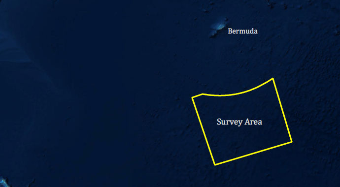
Map showing the area mapped during the Mapping Deepwater Areas Southeast of Bermuda in Support of the Galway Statement on Atlantic Ocean Cooperation, including a focused survey area south of Bermuda covering 20,500 square kilometers. Image courtesy of the NOAA Office of Ocean Exploration and Research. Download map (jpg, 5.9 MB).
Mapping Deepwater Areas Southeast of Bermuda in Support of the Galway Statement on Atlantic Ocean Cooperation was a 20-day telepresence-enabled expedition on NOAA Ship Okeanos Explorer to collect critical information and acquire data on priority exploration areas identified by the ocean management and scientific communities.
The expedition was the first government-supported, focused mapping survey in support of the Atlantic Ocean Research Alliance (AORA) Atlantic Seabed Mapping International Working Group (ASMIWG) and the Galway Statement on Atlantic Ocean Cooperation. It was the second expedition in support of the Atlantic Seafloor Partnership for Integrated Research and Exploration (ASPIRE) campaign, a major multi-year, multi-national collaborative field program focused on raising collective knowledge and understanding of the North Atlantic Ocean.
Highlights from the expedition are summarized below. For more information, download the summary fact sheet (pdf, 2.7 MB.

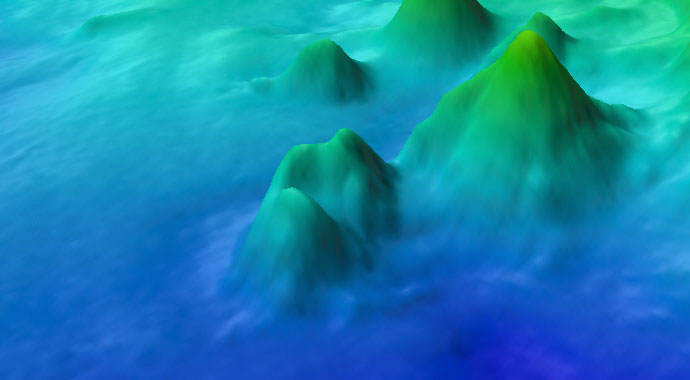
Kongsberg EM302 bathymetry data collected on NOAA Ship Okeanos Explorer during the expedition, including a focused survey area over 20,500 square kilometers, an area larger than Massachusetts. Exploration mapping revealed a complex seafloor structure, including previously undetected distinct conical features, a true seamount, and southwest-northeast trending linear ridges. Image courtesy of the NOAA Office of Ocean Exploration and Research. Download map (jpg, 8.3 MB).
During the expedition, the Okeanos team mapped a total of over 52,000 square kilometers (20,400 square miles), including targeted mapping of 20,500 square kilometers identified as a priority area using the ASMIWG suitability models. The ship traveled over 7,200 linear kilometers (4,500 miles), collecting mapping data at all times. All together, over 150 GB of mapping data was collected, including multibeam bathymetry, backscatter, and water column data; sub-bottom data; and split-beam sonar data.
These mapping efforts support the ASPIRE goal to extend seafloor mapping coverage in the U.S. Exclusive Economic Zone and international waters in support of Seabead 2030 and collected mapping data will directly contribute to the Galway Statement on Atlantic Ocean Cooperation and the Atlantic Ocean Research Alliance’s deep-sea mapping and exploration efforts.
, is topped with distinct cones arounds depths of 4,396 meters (2.7 miles) that rise over 910 meters (2,985 feet) above the seafloor. Prior to this expedition, these features were completely unexplored. The colors and units in the corresponding profile are in meters; white contour lines are 100-meter (328-foot) intervals.")
This ridge feature, extending over 30 kilometers (18.6 miles), is topped with distinct cones around depths of 4,396 meters (2.7 miles) that rise over 910 meters (2,985 feet) above the seafloor. Prior to this expedition, these features were completely unexplored. The colors and units in the corresponding profile are in meters; white contour lines are 100-meter (328-foot) intervals. Image courtesy of the NOAA Office of Ocean Exploration and Research. Download larger version (jpg, 699 KB).
 above the seafloor. Technically defined as a knoll, this distinct mound was a relatively unique feature since it was not associated with the southwest,-northeast trending linear ridges crossing the survey area. It is 11 kilometers (6.8 miles) from flank to flank and likely volcanic in origin. The colors and units in the corresponding profile are in meters; white contour lines are 100-meter (328-foot) intervals.")
Almost twice the height of the Empire State Building, this not-quite-a-seamount stands 800 meters (2,625 feet) above the seafloor. Technically defined as a knoll, this distinct mound was a relatively unique feature since it was not associated with the southwest-northeast trending linear ridges crossing the survey area. It is 11 kilometers (6.8 miles) from flank to flank and likely volcanic in origin. The colors and units in the corresponding profile are in meters; white contour lines are 100-meter (328-foot) intervals. Image courtesy of the NOAA Office of Ocean Exploration and Research. Download larger version (jpg, 1.1 MB).
Expedition highlights to support efforts to characterize water column habitats throughout the Atlantic basin using acoustics, visual observations, and emerging technologies included mapping a previously unknown seamount, collecting split-beam and multibeam data of water column habitats, and using a combination of backscatter and bathymetry to identify potential areas of younger lava flows relative to surrounding older oceanic crust. The team also completed 85 expendable thermograph (XBT) profiles to measure water column temperatures and adjust the ship’s multibeam sonar mapping system to ensure accurate data collection.
Throughout the expedition, U.S., Canadian, and European Union students and scientists participated both on the ship and remotely. The ship hosted two international visiting scientists from Memorial University of Newfoundland in Canada and the University of Kiel in Germany; these scientists are already making use of data and experiences from this expedition.
Continuing with its mission of training the next generation of ocean explorers, the NOAA Office of Ocean Exploration and Research (OER) hosted three Explorers-in-Training and one student from the NOAA Educational Partnership Program on the ship. A NOAA Teacher at Sea from the Peddie School in Highstown, New Jersey, also joined the expedition at sea, blogging and sharing her experiences throughout.
The Okeanos team also hosted five live interactions with over 85 individuals from the NOAA Seattle Science MiniROV Camp, the Engineeristas Technology Camp, and other groups visiting the University of New Hampshire.