This media resources page provides members of the media with information; resources; and broadcast-, print-, and web-quality imagery developed during the Océano Profundo 2018: Exploring Deep-sea Habitats off Puerto Rico and the U.S. Virgin Islands expedition.
From October 30 through November 20, 2018, NOAA and partners will conduct a telepresence-enabled ocean exploration expedition on NOAA Ship Okeanos Explorer to collect critical baseline information about unknown and poorly understood deepwater areas surrounding Puerto Rico and the U.S. Virgin Islands. The expedition begins and ends in San Juan, Puerto Rico.
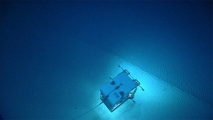
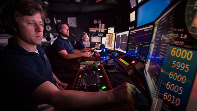
During the cruise, our at-sea and shore-based science teams will work together to map the seafloor and make deepwater scientific observations in these areas. Live video of remotely operated vehicle (ROV) dives can be viewed online in real time from October 31 - November 19.
The expedition team will conduct 24-hour operations consisting of daytime ROV dives and overnight mapping operations, including during transit. Mapping and ROV dives with high-resolution visual surveys and limited sampling activities will focus on priority deepwater areas surrounding Puerto Rico and the U.S. Virgin Islands. Dive sites are expected to include seamounts, submarine canyons, valleys, troughs and trenches, and unmapped or poorly mapped areas. This expedition will contribute to foundational information in the region to catalyze further exploration, research, and management activities.
On this page:
Why? | Who? | Highlight Videos & Images | Background Info | Contact Info
The North Atlantic, including the Caribbean Sea, plays a pivotal role to humankind, providing a myriad of ecosystem services, such as food security, protection from hazards, trade, tourism, and recreation, which collectively provide employment and livelihood opportunities for millions of people.
Despite its critical importance, we have only begun to understand the region’s deep-sea resources, oceanography, bathymetry, geology, ecosystems, and trans-Atlantic biological connectivity. The deep waters surrounding Puerto Rico and the U.S. Virgin Islands are some of the least explored in the entire U.S. Exclusive Economic Zone (EEZ) of the Atlantic Ocean, and information collected during the expedition will help fill important knowledge gaps.
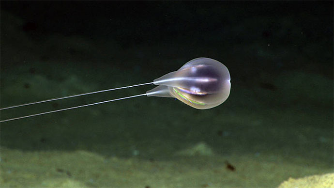
The deep waters of Puerto Rico and the U.S. Virgin Islands contain a wide diversity of deepwater habitats and geological features, including seamounts, submarine canyons, valleys, troughs, and trenches, the vast majority of which have never been explored.
This expedition will be one of several expeditions in 2018-2020 that will contribute directly to the Atlantic Seafloor Partnership for Integrated Research and Exploration (ASPIRE) campaign, a major multi-year, multi-national collaborative field program focused on raising our collective knowledge of the North Atlantic Ocean.
The Océano Profundo 2018: Exploring Deep-sea Habitats off Puerto Rico and the U.S. Virgin Islands expedition will address science and management priorities put forward by NOAA, resource managers and scientists from the region. NOAA priorities for the expedition include a combination of science, education, outreach, and open data objectives that will support management decisions at multiple levels:
The expedition involves a number of NOAA partners including the Office of Oceanic and Atmospheric Research's Office of Ocean Exploration and Research, Office of Marine and Aviation Operations; National Marine Fisheries Service; National Ocean Service; and National Environmental Satellite, Data, and Information Service’s National Centers for Environmental Information.
The individuals listed below will primarily lead activities during the expedition. They will coordinate input from multiple scientists and managers participating from shore to plan dives and are several of the voices you hear on the live video feeds and the primary participants in outreach events. For a full list of our on-ship team, please visit this page.

Steve is a PhD candidate in the Department of Biology at Temple University. He is broadly interested in the ecology of deep-sea corals. His dissertation research focuses on how deep-sea water masses and abiotic factors influence coral diversity and distribution across depth, particularly on isolated seamounts. Steve has participated as a scientist at sea as well as ashore on several expeditions aboard the E/V Nautilus and Okeanos Explorer in the Gulf of Mexico, Caribbean Sea, and central Pacific Ocean.
Steve received his B.S. in Marine Sciences at the University of Connecticut at Avery Point. He then went on to receive an M.S. in Marine Biology at the University of Maine, Darling Marine Center, where he studied biogeographic patterns on seamount communities in the Drake Passage and Southern Ocean. He is currently in the Cordes Lab at Temple University studying deep-water corals in the Caribbean Sea and equatorial Pacific Ocean.

Dr. Stacey Williams holds a Ph.D. in Biological Oceanography from the University of Puerto Rico, Mayaguez, where she studied the population dynamics of a keystone herbivore, the long-spined sea urchin, Diadema antillarum. She is a co-founder of a non-profit organization, Institute for Socio-Ecological Research, and an environmental consulting company, Coastal Survey Solutions, LLC. As a benthic ecologist, her research has been mainly based on assessing the health status of shallow-water reefs throughout the Caribbean. However, in the past 10 years, she has characterized the benthic communities of many mesophotic reefs around Puerto Rico and the U.S. Virgin Islands. In 2015 and 2017, she was part of a team to quantitatively describe the deepwater habitats at important fishing grounds for queen and silk snappers off the west coast of Puerto Rico. Her research interests have focused on examining and understanding the interactions and multiple drivers affecting sessile-benthic and fish communities at shallow to deepwater habitats.

Dr. Daniel Wagner works as an expedition coordinator for the NOAA Office of Ocean Exploration and Research. Daniel has conducted fieldwork on deep-sea ecosystems since 2006 and has since spent over 500 days at sea during 25 multi-disciplinary research expeditions that explored deep-sea habitats throughout the Indo-Pacific, Atlantic, and Southern Oceans. Daniel grew up in Ecuador, where at a young age he interned at the Galapagos National Park, an experience during which he developed a deep fascination for nature and the oceans. Daniel then moved to Hawaii, where he earned a Bachelor of Science in Biology from Hawaii Pacific University, as well as a Master of Science and Ph.D. degrees in Oceanography from the University of Hawaii at Mānoa. Daniel resides in Charleston, South Carolina.

Derek Sowers holds a B.S. in Environmental Science from the University of New Hampshire and an M.S. in Marine Resource Management from Oregon State University. He has 14 years of previous coastal research and management experience, including work for NOAA's National Estuarine Research Reserve network and the Environmental Protection Agency's National Estuary Program in both Oregon and New Hampshire. Derek has participated in ocean research expeditions in the Arctic Ocean, Gulf of Maine, Gulf of Mexico, Pacific Northwest continental shelf, North Atlantic Canyons, and New England Seamounts.
During at-sea expeditions, Derek leads sonar data collection by planning the ship's mapping routes and producing maps of seafloor and water column features to guide exploration. On shore, Derek works at the Center for Coastal and Ocean Mapping/Joint Hydrographic Center at the University of New Hampshire to coordinate future mapping expeditions, process and archive data, and collaborate with other scientists. Derek is also a part-time Oceanography Ph.D. student focused on using Extended Continental Shelf and Okeanos Explorer data to develop marine ecological classification maps.
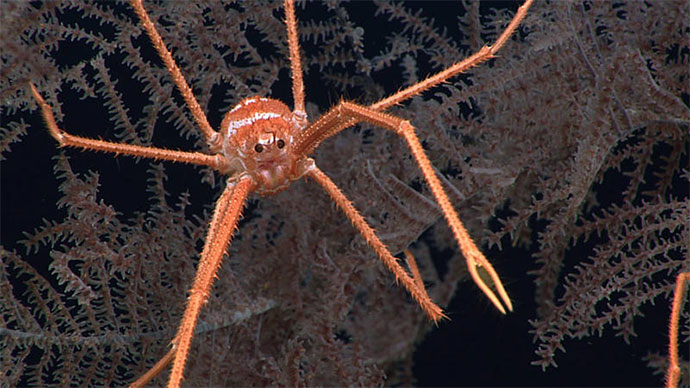
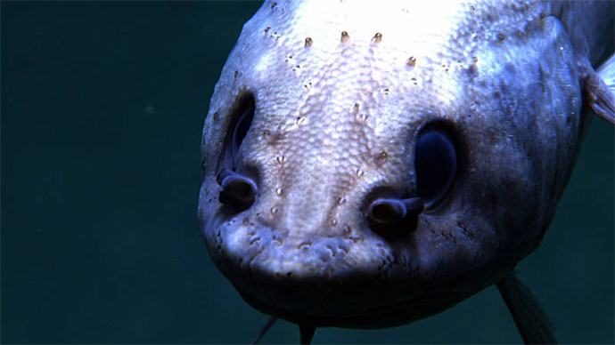
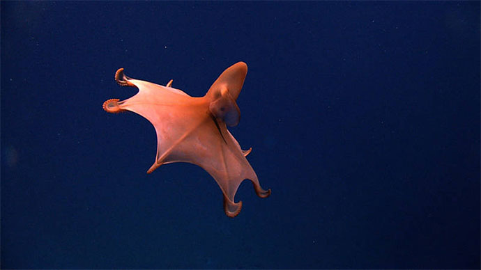
Dive highlight videos, short video clips, and photos will be posted online as they are available.
Please contact Katie Wagner for high-res footage, B-roll, and other materials at (301) 734-1008 or Katie.Wagner@noaa.gov.
Access LIVE video feeds here
Expedition home page
Please see the Contact Us page for information regarding specific media, public, and government inquiries.