by Daniel Wagner, Expedition Coordinator, NOAA Office of Ocean Exploration and Research
Stacey M. Williams, Institute for Socio-Ecological Research, Coastal Survey Solutions LLC
Steve Auscavitch, Expedition Science Co-Lead, Temple University
Derek Sowers, Expedition Mapping Lead, NOAA Office of Ocean Exploration and Research
Scott France, Okeanos Explorer Science Advisor, University of Louisiana at Lafayette
 operations to support science and management priorities of the Caribbean Region.")
Map showing the operating area of the Océano Profundo 2018 expedition to Puerto Rico and the U.S. Virgin Islands. This expedition will start and end in San Juan, Puerto Rico, and conduct mapping and remotely operated vehicle operations to support science and management priorities of the Caribbean Region. Image courtesy of the NOAA Office of Ocean Exploration and Research. Download image (jpg, 2.0 MB).
From October 30 through November 20, 2018, NOAA and partners will conduct a telepresence-enabled ocean exploration expedition on NOAA Ship Okeanos Explorer to collect critical baseline information about unknown and poorly understood deepwater areas surrounding Puerto Rico and the U.S. Virgin Islands. The deep waters of Puerto Rico and the U.S. Virgin Islands contain a wide diversity of habitats and geological features, including seamounts, submarine canyons, valleys, troughs, and trenches, the vast majority of which have never been explored in detail.
As with previous NOAA Ship Okeanos Explorer expeditions, NOAA will work closely with the science and resource management community to explore priority deepwater areas. Remotely operated vehicle (ROV) operations will use NOAA's dual-body ROV capable of diving to 6,000-meter depths to explore a diversity of poorly known deep seafloor and midwater habitats, as well as unique geological features. Mapping operations will use the Okeanos Explorer’s state-of-the-art sonar systems (Kongsberg EM302 multibeam, Simrad EK60 split-beam, Knudsen 3260 chirp sub-bottom profiler, and Teledyne Acoustic Doppler Current Profiler) and concentrate on seafloor and water column areas with little or no high-quality sonar data. Additionally, the expedition will use the ship’s high-bandwidth satellite connection to engage a broad spectrum of scientists, resource managers, and the public in telepresence-based exploration.
The Océano Profundo 2018 expedition will be one of several expeditions in 2018-2020 that will contribute directly to the Atlantic Seafloor Partnership for Integrated Research and Exploration (ASPIRE) campaign, a major multi-year, multi-national collaborative field program focused on raising our collective knowledge of the North Atlantic Ocean. The North Atlantic, including the Caribbean Sea, plays a pivotal role to humankind, providing a myriad of ecosystem services, such as food security, protection from hazards, trade, tourism, and recreation, which collectively provide employment and livelihood opportunities for millions of people.
 and grouper habitat.")
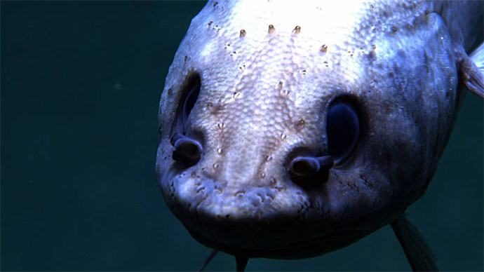
The Océano Profundo 2018 expedition will explore various deepwater areas that are of interest to resource management of the region, such as poorly known deepwater snapper (shown in image) and grouper habitat. Image courtesy of the NOAA Office of Ocean Exploration and Research, Exploring Puerto Rico’s Seamounts, Trenches, and Troughs. Download image (jpg, 1.7 MB).
Despite its critical importance, we have only begun to understand the region’s deep-sea resources, oceanography, bathymetry, geology, ecosystems, and trans-Atlantic biological connectivity. The deep waters surrounding Puerto Rico and the U.S. Virgin Islands are some of the least explored in the entire U.S. Exclusive Economic Zone of the Atlantic Ocean, and information collected during the expedition will help fill important knowledge gaps.
In addition to being largely unexplored, the deep waters of Puerto Rico and the U.S. Virgin Islands also include various areas where more information is needed to support management efforts. Specifically, deep-sea environments inhabited by commercial fishery species, particularly deepwater grouper and snapper, as well as deeper extensions of marine protected areas in this region, remain mostly unexplored. The Océano Profundo 2018 expedition will involve mapping and ROV operations in several of these areas and thereby provide critical baseline information to support the science and management needs of the region. Furthermore, the Caribbean Sea is an area of active tectonic activity, which is subject to earthquakes, landslides, and other geohazards. During this expedition, we will explore several such geological areas of interest, providing important insights into past, present, and future geohazards of the Caribbean.
The Océano Profundo 2018 expedition will address science and management priorities put forward by NOAA, resource managers, and scientists from the region. NOAA priorities for the expedition include a combination of science, education, outreach, and open data objectives that will provide a better understanding of this important, yet mostly unexplored, marine region. These objectives include:

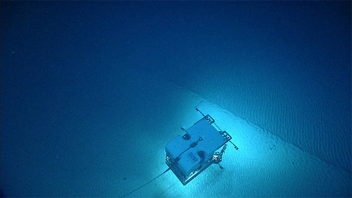
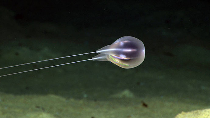
During the Océano Profundo 2018 expedition, ROV Deep Discoverer will be used to acquire high-definition visual data and collect limited physical samples in poorly explored areas off Puerto Rico and the U.S. Virgin Islands. Image courtesy of the NOAA Office of Ocean Exploration and Research, Exploring Puerto Rico’s Seamounts, Trenches, and Troughs. Download image (jpg, 1.3 MB).
This 22-day expedition will start in San Juan, Puerto Rico, on October 30, 2018, and end in San Juan, Puerto Rico, on November 20, 2018. During the expedition, we will conduct 24-hour operations, including daytime ROV dives to depths ranging between 250-6,000 meters (820 - 19,685 feet) and overnight mapping operations to depths of 6,000 meters, as well as continuous shore-side participation via telepresence technology.
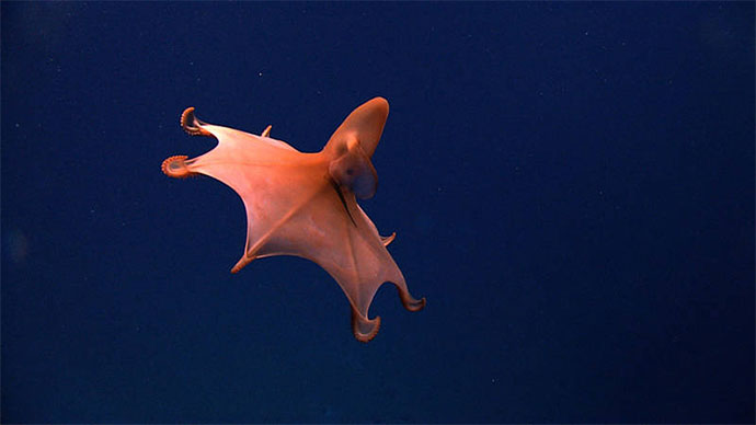
ROV dives will focus on exploring deep-sea coral and fish habitats, midwater habitats, submarine canyons, seamounts, trenches, unique geological features, and other poorly known deep-sea habitats. Mapping operations will concentrate on seafloor and water column areas with little or no high-quality sonar data, as well as to support ROV operations and identify potential maritime heritage sites. Furthermore, the expedition will include a limited number of CTD casts in order to collect additional environmental information about poorly studied midwater habitats.
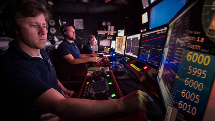
NOAA uses telepresence technology to transmit data in real time to a shore-based science team who actively participate in expeditions. These shore-based scientists interact with the ship through a teleconference line and a series of Internet-based collaboration tools. Using these communication tools, shore-based scientists help guide at-sea operations in real time, extending the reach of ocean exploration to a much larger group than could possibly be accommodated onboard a single research vessel.
During the Océano Profundo 2018 expedition, scientists will also work together and stand watches at several Exploration Command Centers (ECCs) around the country. When Okeanos Explorer expeditions first started over 10 years ago, ECCs were the only way that scientists could engage with the ship. With advancing technologies, scientists can now participate in expeditions from any place with an Internet connection. However, EECs still provide highly effective science collaboration centers, as they allow many scientists to come together and focus in a single location to share their expertise. Close to a dozen ECCs will be active throughout the country during this expedition, providing invaluable mission support from shore.

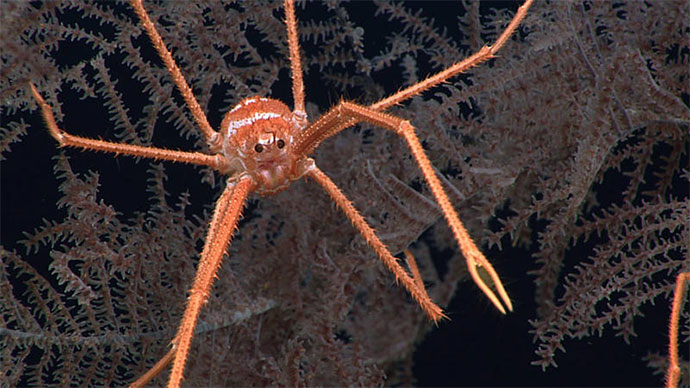
The Océano Profundo 2018 expedition will explore vulnerable habitats of interest to resource managers and scientists such as deep-sea coral and sponge habitats off Puerto Rico and the U.S. Virgin Islands, which are some of the least known in U.S. waters of the Atlantic Ocean. Image courtesy of the NOAA Office of Ocean Exploration and Research, Exploring Puerto Rico’s Seamounts, Trenches, and Troughs. Download image (jpg, 1.5 MB).
Anyone with an Internet connection can follow along with the expedition, as high-definition video of dives will be streamed live over the Internet from October 31 through November 19, 2018. The same telepresence technology that allows scientists from around the world to participate in the expedition from land will also enable interested members of the public to experience deep-sea exploration, the wonder of discovery, and the fascination of science in real time. Additionally, mission logs, daily updates, educational materials, and multimedia elements will be added to this website throughout the expedition.