by Jason Chaytor, U.S. Geological Survey
Michael Rasser, Bureau of Ocean Energy Management
Mark Mueller, Bureau of Ocean Energy Management
Alden Denny, Bureau of Ocean Energy Management
Amy Gartman, U.S. Geological Survey
Amanda Demopoulos, U.S. Geological Survey
November 7, 2019

Most of the seafloor explored during Dive 07 of the 2019 Southeastern U.S. Deep-sea Exploration was covered with these manganese nodules, the subject of the Deep Sea Ventures pilot test nearly five decades ago. Image courtesy of the NOAA Office of Ocean Exploration and Research, 2019 Southeastern U.S. Deep-sea Exploration. Download larger version (jpg, 1.7 MB).
Fifty years ago, the company Deep Sea Ventures Inc. performed extensive exploration and a pilot test of deep-sea mining technology on the Blake Plateau, deploying a system to collect seafloor sediment and manganese nodules by airlift pumping through a pipe to the surface. The mining activities at this site were never intended for commercial mining, but rather to test mining equipment in a shallower and more accessible environment than proposed mine sites in the central Pacific. In 1982, the U.S. Geological Survey revisited the site as part of a larger effort to understand the distribution of mineral deposits on the Blake Plateau and the nature of the seafloor environments in which they were located. Physical samples, geophysical data, and bottom photographs were all collected in support of this research.
Continuing on past efforts to survey the Blake Plateau, the 2019 Southeastern U.S. Deep-sea Exploration team will conduct mapping and remotely operated vehicle operations in order to gather baseline data on the deep-sea benthic environment of the area. Dives at the Deep Sea Ventures site will inform scientific understanding about whether signs of disturbance can still be observed long after deep-sea mining activities occurred.

This map shows the Deep Sea Ventures site with bathymetry data from the NOAA Ship Okeanos Explorer 2019 Windows to the Deep expedition. This area was visited during the 2019 Southeastern U.S. Deep-sea Exploration. Image courtesy of Jason Chaytor, U.S. Geological Survey. Download larger version (jpg, 2.4 MB).
The Blake Plateau is composed of a variety of substrates, including crusts and nodules that support distinct benthic communities. Currently, our understanding of the potential ecological impacts that affect these environments and the time required to recover, if recovery is possible at all, is extremely limited. This is because there have been very few mining-related activities in the deep sea and even less observational data to examine the potential impacts. Long-term observation opportunities are particularly rare. A history of deep-sea mining related disturbance and subsequent time series of observations spanning decades make this proposed site unique. It is hoped that new observations of the area will provide insight into how, and whether, undersea environments recover from disturbance from mining-related activities.

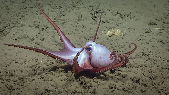
A cusk eel swims along the seafloor in the area of the Deep Sea Ventures site during Dive 07 of the 2019 Southeastern U.S. Deep-sea Exploration. Image courtesy of the NOAA Office of Ocean Exploration and Research, 2019 Southeastern U.S. Deep-sea Exploration. Download larger version (jpg, 1.7 MB).
The data collected here can help develop objective environmental and ecological baselines that can inform reviews, future decisions, and mitigation measures related to deep-sea mining in other areas. As with all NOAA Ship Okeanos Explorer missions, data collected during this expedition will be publicly available following the cruise.

In the 1980s, the U.S. Geological Survey marked the Deep Sea Ventures site with approximately 100 concrete “patio blocks” to help them evaluate the environmental conditions in the area. One of these blocks was seen during Dive 07 of the 2019 Southeastern U.S. Deep-sea Exploration. Image courtesy of the NOAA Office of Ocean Exploration and Research, 2019 Southeastern U.S. Deep-sea Exploration. Download larger version (jpg, 1.3 MB).