Windows to the Deep 2021: Southeast U.S. ROV and Mapping
October 26 - November 15, 2021
Expedition Plan
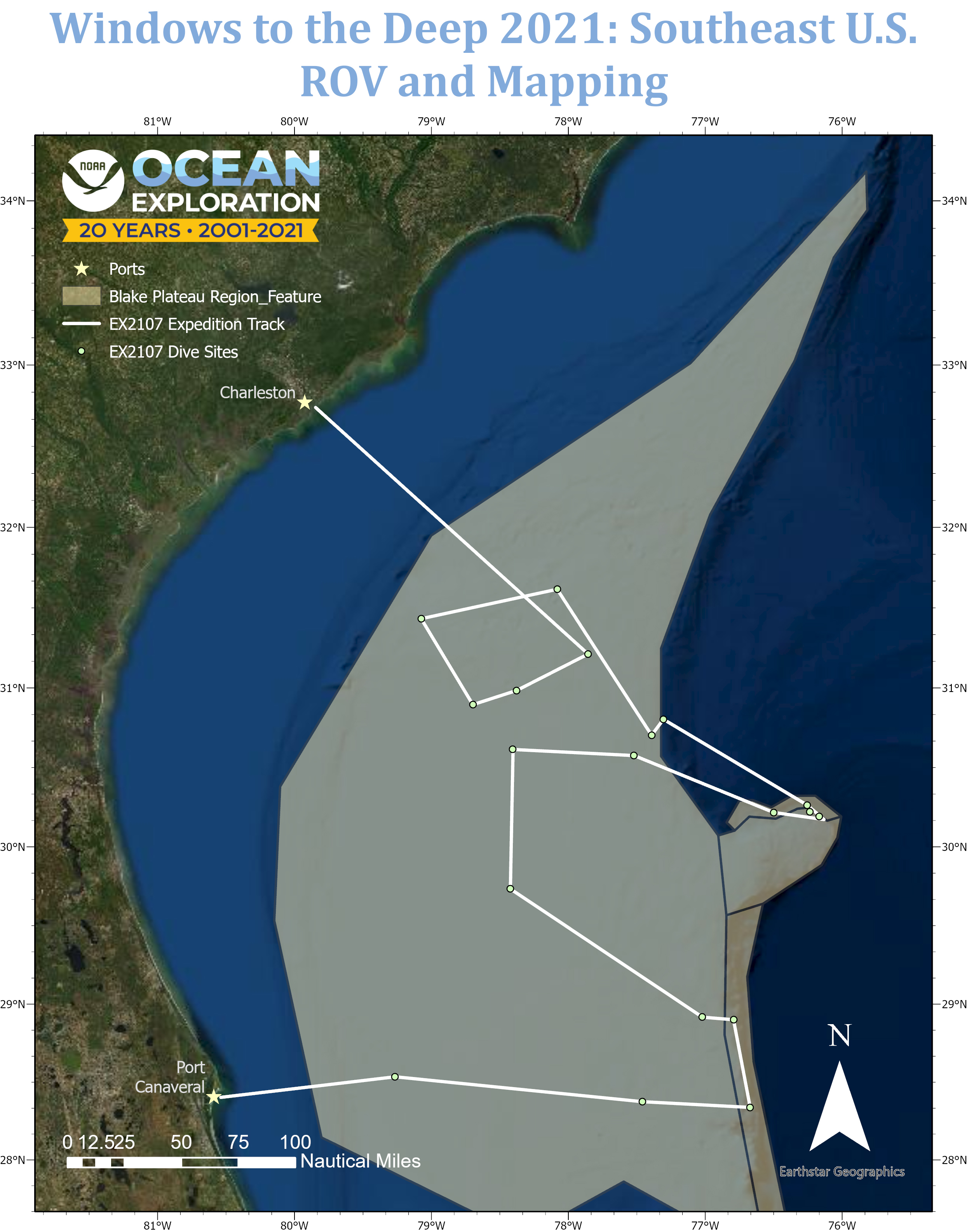
From October 26 to November 15, NOAA Ocean Exploration and partners will conduct a telepresence-enabled ocean exploration expedition on NOAA Ship Okeanos Explorer. The Windows to the Deep 2021: Southeast ROV and Mapping expedition will collect critical information about unexplored and poorly understood deepwater areas of the Blake Plateau region of the North Atlantic Ocean. This foundational information will encourage further exploration and research and inform resource management decisions and activities in the region.
This expedition will build on previous expeditions in the region, including the 2003 Windows to the Deep expedition, Windows to the Deep 2018, Windows to the Deep 2019, the 2019 Southeastern U.S. Deep-Sea Exploration, and the DEEP SEARCH (DEEP Sea Exploration to Advance Research on Coral/Canyon/Cold seep Habitats) expeditions. These expeditions have contributed greatly to what we now know about environments along the edge of the southeastern U.S. continental margin.
Expedition Goals
Our priorities for Windows to the Deep 2021: Southeast U.S. ROV and Mapping include a combination of science, education, outreach, and open-data objectives that will provide a better understanding of this important marine region. Specific expedition goals are:
- Acquire data on deepwater benthic and water column habitats of the southeastern U.S. continental margin to support priority science and management needs
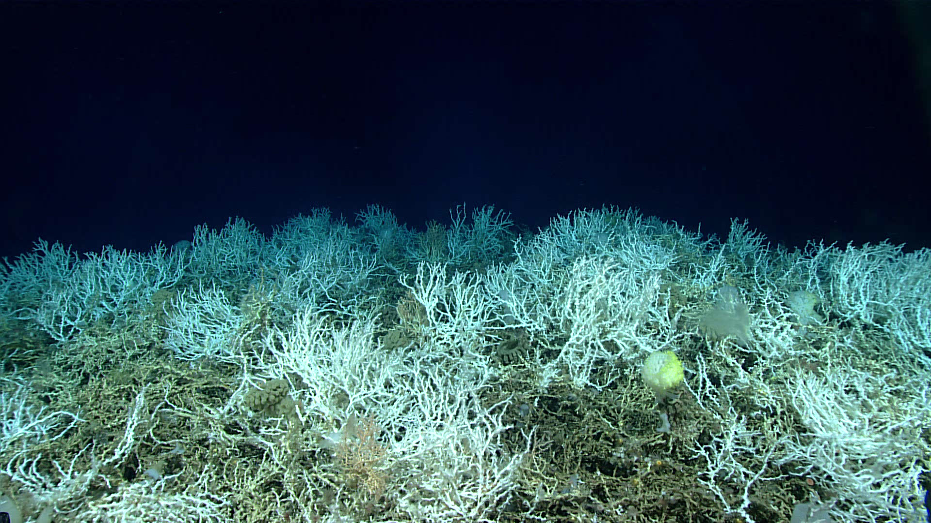
- Identify, map, and explore the diversity and distribution of benthic habitats, including fish habitats and deep-sea coral and sponge communities
- Explore U.S. maritime heritage by identifying and investigating sonar anomalies
- Investigate biogeographic patterns of deep-sea ecosystems and connectivity across the southeastern U.S. continental margin for use in broader comparisons of deepwater habitats throughout the Atlantic basin
- Collect and document samples for NOAA's Ocean Exploration Collection at the Smithsonian’s National Museum of Natural History (biological) and at Oregon State University Geological Repository (geological) so that they are available for detailed study
- Map, survey, and sample geological features of the southeastern U.S. continental margin to better understand the geological context of the region and improve knowledge of past and potential future geohazards
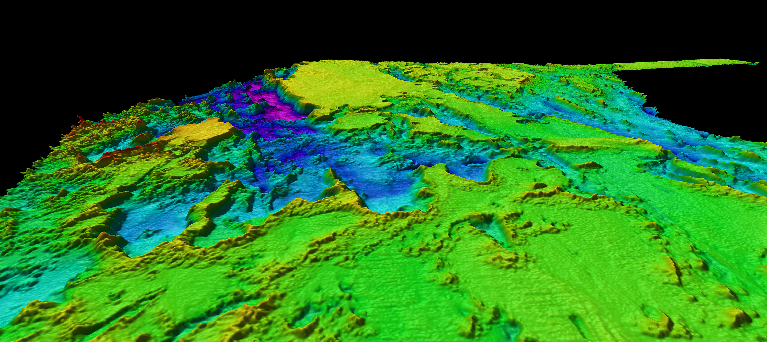
- Collect high-resolution bathymetry in areas with no or low-quality sonar data
- Acquire a foundation of remotely operated vehicle (ROV), sonar, and oceanographic data to better understand the characteristics of the water column and the fauna that live there
- Engage a broad spectrum of the scientific community and public in telepresence-enabled exploration, and provide publicly accessible data and information products to spur further exploration, research, and management activities
This expedition supports the National Strategy for Mapping, Exploring and Characterizing the United States Exclusive Economic Zone (pdf) and Seabed 2030 and will contribute to the Atlantic Seafloor Partnership for Integrated Research and Exploration (ASPIRE) in support of the Galway Statement on Atlantic Ocean Cooperation (pdf).
Operations
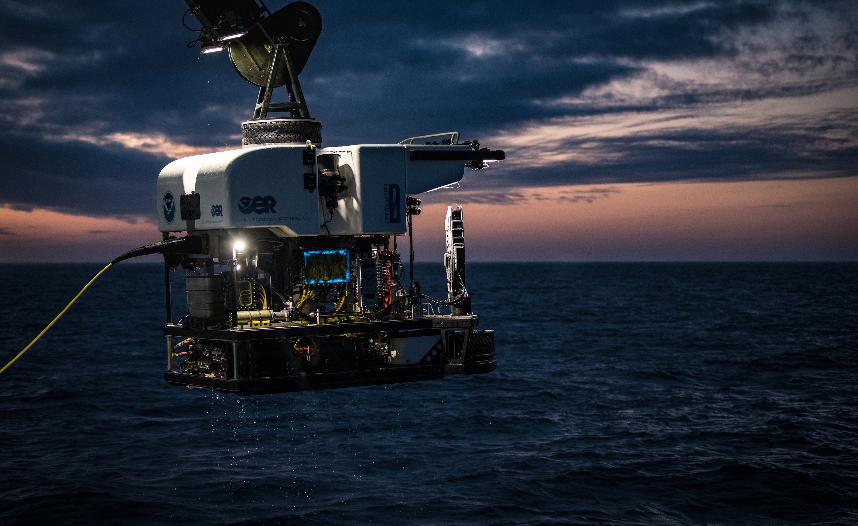
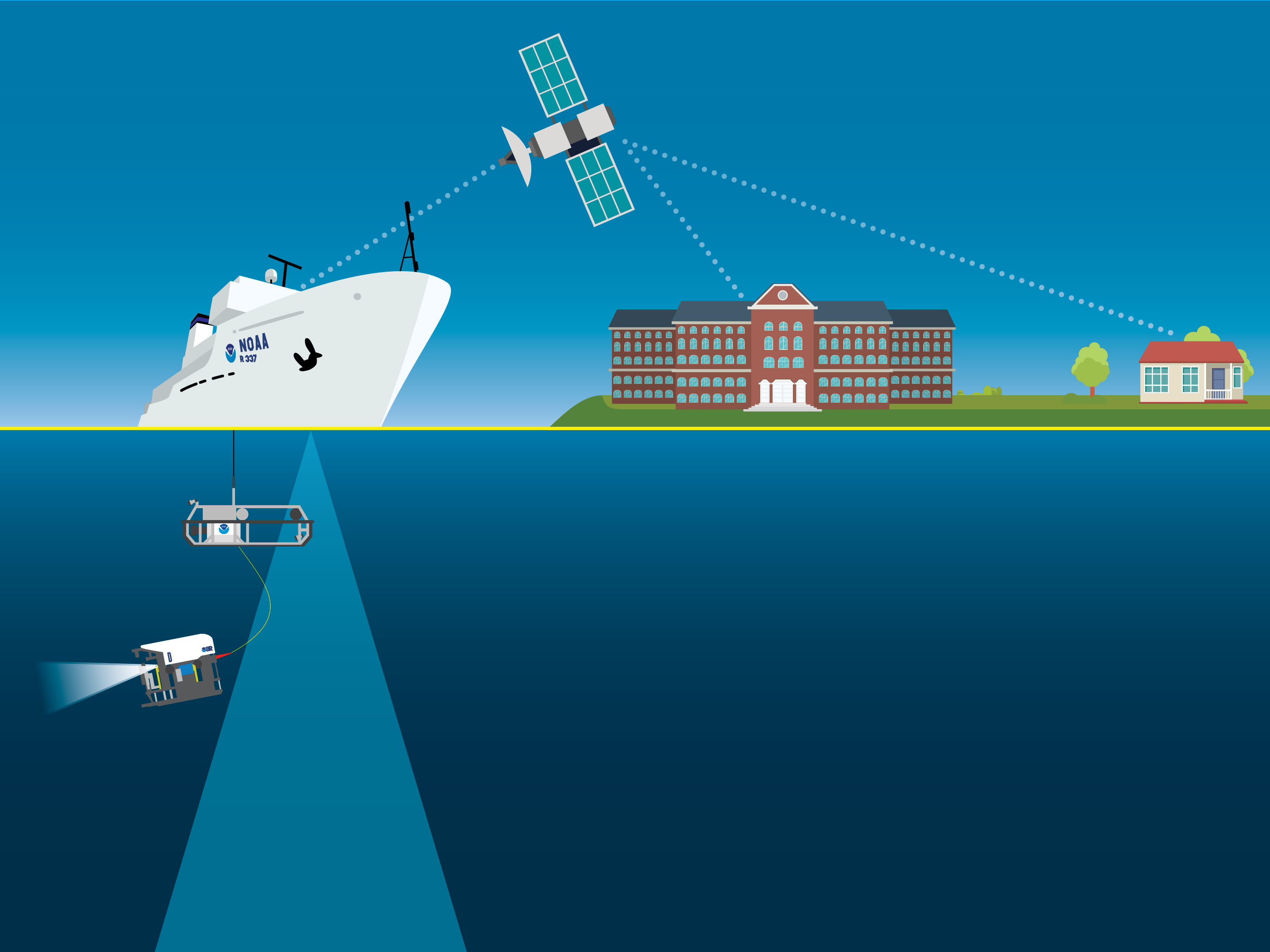
During Windows to the Deep 2021, at-sea and shore-based science teams will work together to explore and map the seafloor and the water column. Our 24-hour operations will include ROV dives during the day and mapping operations at night. We will use the state-of-the-art deepwater mapping systems on Okeanos Explorer, our dual-bodied ROV system that can dive to depths of 6,000 meters (3.7 miles), and a high-bandwidth satellite connection for real-time ship-to-shore communications.
During the ROV dives, we will collect high-resolution visual surveys (video) of water column and seafloor habitats and a limited number of biological and geological samples. We expect the dives to feature deep-sea coral and sponge habitats, biogenic (coral) mounds, interesting geological features, and more. We will stream live video of the dives online from October 27 to November 14.
Telepresence-Enabled Exploration
NOAA Ocean Exploration uses telepresence technology to transmit data in real time. A high-bandwidth satellite connection, teleconference line, and online collaboration tools enable the majority of an expedition’s science team to remain on shore. Thus, scientists can join an expedition from land, from anywhere in the world, and contribute their expertise to at-sea operations as they are happening. By extending the reach of ocean exploration, these communications tools allow us to engage more scientists than could possibly be accommodated aboard any single ship.
Exploration for All
Using telepresence, NOAA Ocean Exploration also invites the public to explore the deep ocean and experience the wonder of discovery and the fascination of science along with us, LIVE. The live video is available to anyone online, giving the public a front row seat to discoveries as they are made.
We have developed web content specifically for this expedition that includes a video and image gallery, expedition updates, dive information, and explorer biographies. In addition, our educator resources are designed to help educators and students engage with the expedition through related products, including standards-based lesson plans, background information, ocean career connections, links to previous NOAA Ocean Exploration-sponsored expeditions, and more.
Published October 20, 2021
Expedition Coordinator
NOAA Ocean Exploration

Mapping Lead
NOAA Ocean Exploration
Biology Science Lead
Florida Atlantic University, Harbor Branch Oceanographic Institute
Biology Science Lead
NOAA Fisheries National Systematics Laboratory and Smithsonian National Museum of Natural History
Scott France
Okeanos Explorer Science Advisor
University of Louisiana at Lafayette