


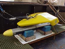
Multibeam towfish for the Klein 5000 side scan sonar resting on deck in its cradle. The unit is approximately 2 meters (long) by 0.2 meters (diameter) and weighs 70 kg (155 lb). The towfish uses 5 beams each on its port and starboard sides to map the seafloor using high frequency (455 kHz) sound pulses. This system is designed so that each swath of sound energy overlaps with the adjacent swaths giving 100% coverage of the seafloor, even at relatively high tow speeds. Click image for larger view.
Klein 5000 Side Scan Sonar
Dr. Bob McConnaughey, Research Fishery Biologist and Project Chief Scientist
RACE Division, NMFS Alaska Fisheries Science Center, Seattle, WA
Side scan sonars use sound to produce images of the seafloor. Such a system consists of three basic components: the towfish, the transmission cable and the topside processing unit. The towfish is dragged near the seafloor where it emits sound pulses and receives echos from the surrounding seabed. Data on seabed composition and form are collected parallel to the path of the towfish, covering a swath extending from below the towfish to some predetermined distance on either side of the tow path. A reinforced cable transmits data from the towfish to a topside processing unit, which stores incoming data and displays an image. Images contain information about the sediment type and general roughness of the seabed. For example, hard areas reflect more energy and are represented as dark areas on the image, while softer areas do not reflect energy as well and are represented with lighter shades. This “backscatter” is absent behind objects or features that rise above the seafloor, and are represented as white shadows in the sonar image. The dimensions of the shadow can be used to infer the size of the target. This technology is commonly used to map seabed features and characterize seafloor habitat complexity.
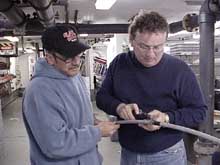
Navy technicians preparing the sonar cable for attachment to the towfish. Although the cable they are holding looks rather ordinary, it is double armored for towing strength yet is also capable of high speed transmission of digital data. Click image for larger view.
Fully digital multibeam side scan sonars are the state of the art for seafloor mapping. Older analog systems are very susceptible to electronic noise which can obscure important seabed features. This may occur as a result of faulty cables, connectors and power supplies. Digital multibeam systems also represent a significant improvement over the previous generation of digital “single beam” systems. These units require relatively slow towing speeds so that the towfish does not “outrun” the returning echos (much the way a boomerang would be lost if thrown from a speeding train). The end result of excessive tow speeds is regular gaps in the seabed coverage. In our simple example, multibeam systems “lengthen the train” by adding additional transducers (which transmit and receive the sound pulses). To accommodate the extra transducers, the multibeam towfish typically are longer (and heavier) than less costly single beam systems. Operating speeds can be as high as 20 knots (in some military systems), compared with 2-3 knot speeds for typical single beam systems, saving both time and money as a result.
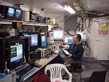
Topside electronic systems for the multibeam side scan sonar system. At lower left are the topside processing units (TPUs) receiving real-time imagery and swath bathymetry data from the towfish. The four navigation system monitors located to the right track vessel and towfish position during survey operations. The closed circuit television at upper left monitors the winch containing the tow/transmission cable, which can be remotely controlled from this location. This control center was created from an empty space on the fish processing deck of the F/V Ocean Explorer. Click image for larger view.
At this time, the Klein 5000 is the only commercially-available digital multibeam side scan sonar system. In addition to the general advantages discussed above, these systems use advanced acoustic processing to produce very high resolution images of the seabed. This capability is particularly important to the Next Generation Tools expedition that is investigating relationships between small-scale geological features and even smaller benthic organisms in Alaskan waters. Each pixel in a typical Klein 5000 image covers an area of the seafloor as small as 7.5 cm by 20 cm (or about the size of a 1 qt container of milk or a can of spray paint). The system can survey swaths of seafloor ranging from 100-300 meters wide, with only minor losses in resolution at the larger swath sizes. Additionally, a swath bathymetry option enables direct measurements of small vertical features on the seabed, such as sand waves, using a process called “interferometry”. Both swath bathymetry data and side scan imagery are generated simultaneously, thus interferometric side scan sonars are very efficient mapping tools. So much so that over a 1,000 MB of data are collected every 19 minutes the Klein system is in use!!
This high level of resolution exceeds what is possible with the most advanced multibeam echosounding sonars that are increasingly used to survey the seabed and collect information for nautical charts. In contrast with a side scan towfish which is deployed a few meters above the seabed and transmits laterally, these “multibeams” (confusing, I know) attach to the vessel and transmit sound downward from the surface. For a number of reasons related to the behavior of sound in water and simple geometry, proximity to the seabed is advantageous if the risk of collision with hard objects or the seabed itself is low. Valued at more than $160,000 apiece, loss or damage to the towfish, not to mention any lost survey time, can be extremely costly.
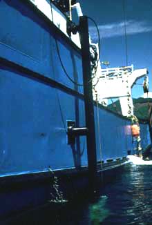
USBL hydrophone that receives acoustic signals from the “transponder” attached to an object being towed behind the survey vessel. The hydrophone is connected to a computer on the vessel and regularly sends a sound pulse to determine the location of the transponder. When not in use, the hydrophone pole is raised out of the water for maximum cruising speed. Click image for larger view.
Other high-tech equipment is required for effective use of a side scan sonar system. In order to assemble (or “mosaic”) a series of images, knowledge of the towfish location is required. To determine the range (distance) and bearing (direction) of the towfish from the vessel, an acoustic beacon is attached to the cable near the towfish and communicates with an underwater listening device (or “hydrophone”) that is attached to a pole extending below the hull of the vessel. Each second, towfish position is calculated and then displayed on computerized navigation charts used by the helmsman. These acoustic positioning systems are known in the offshore survey business as ultra-short baseline (USBL) systems. Accurate information from a USBL system is very dependent on a careful installation and calibration process. Additional information from sensors in the towfish itself and on the vessel improve the overall accuracy of this method. When all this information is combined with the known position of the vessel (using GPS satellite data, for example), the exact location of the towfish is determined and high quality maps of seabed complexity are possible.
Sign up for the Ocean Explorer E-mail Update List.