

Innovative Technology and Partnership Leads to New EEZ Mapping
Completed
Overview
In the fall of 2019, capitalizing on existing hydrographic survey contract mechanisms through NOAA’s Office of Coast Survey, the NOAA Office of Ocean Exploration and Research (OER) and the National Oceanographic Partnership Program funded the geodata specialist company Fugro to conduct a survey in the Blake Plateau region off the coasts of Georgia and Florida. With less than 45 percent of the nation’s U.S. Exclusive Economic Zone (EEZ) mapped to modern standards and even less of it characterized, the work to map previously unmapped areas of the U.S. EEZ will help to close known gaps in ocean data, allowing a more effective balance of the sustainable use of ocean resources with conservation and management efforts.

Figure 1. Locations of Fugro surveys in Area 1A, Area 1B and backscatter normalization. Image courtesy of Fugro. Download image (jpg, 224 KB).
How it Works
OER teamed with Fugro to develop a new approach to mapping deepwater areas of the EEZ. Fugro has developed remote surveying and data compression capabilities that make it possible to conduct high-resolution seafloor mapping surveys with minimal staff onboard the survey vessel. Two key Fugro capabilities that support this approach include:
- OARS®: Short for Office Assisted Remote Services, this cloud-based system, developed by Fugro, enables qualified surveyors to control operations remotely via command centers, strategically located around the globe. Communication between vessel and survey staff is available 24 hours a day, 7 days a week, allowing for real-time collaboration on project planning, status, and amendments. Additionally, clients (such as NOAA) can monitor survey activities through a secure web browser interface.
- Back2Base™: Back2Base is a set of technologies and processes that enable survey data to be reliably and securely transferred between Fugro survey vessels and shore-based Fugro processing offices. Data are organized and packaged into highly compressible formats and queued for automatic transmission on a line-by-line basis or timed interval. Once received by office staff, information is decompressed, unpackaged, and made available for processing or quality control.
These technologies result in improved communications and transparency of surveying activities in near real time, while allowing additional EEZ survey data to be collected.
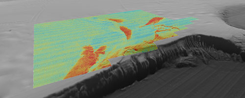
 show where the seafloor is soft and/or smooth. Coral mounds, exposed carbonate, and sand drifts can be interpreted from these high backscatter anomalies.")
Figure 2. Multibeam backscatter data draped on bathymetry from the southern portion of the Blake Plateau survey. Warm colors are high intensity backscatter anomalies that show where the seafloor is hard and/or coarse. Low backscatter (cool colors) show where the seafloor is soft and/or smooth. Coral mounds, exposed carbonate, and sand drifts can be interpreted from these high backscatter anomalies. Image courtesy of Fugro. Download image (jpg, 152 KB).
Meeting Presidential Directives and Supporting Global Initiatives
As a result of this first “proof-of-concept” Fugro survey, NOAA received more than 28,000 square kilometers of new EEZ mapping in February 2020. While initiated before the Presidential Memorandum on Ocean Mapping of the United States Exclusive Economic Zone and the Shoreline and Nearshore of Alaska was issued in November 2019, the project fully aligns with the goals and objectives of the directive. Specifically, the Presidential Memorandum instructs the nation to “act boldly” and “harness cutting-edge science, new technologies, and partnerships to unlock the potential of our oceans through increased ocean mapping.”
Concurrent to the bathymetric survey, sub-bottom profiler, seafloor, and water column backscatter were also collected. OER and Fugro also collaborated to collect data in support of establishing shallow and deepwater backscatter reference areas that can be used in the future by NOAA Ship Okeanos Explorer and other vessels to cross calibrate their multibeam sonars to provide consistent seafloor backscatter data.
The U.S. emphasis on ocean mapping complements global initiatives such as The Nippon Foundation-GEBCO Seabed 2030 Project , and the upcoming United Nations Decade of Ocean Science for Sustainable Development which encourages collaboration of government agencies, non-governmental organizations, academia, and industry to map, explore and characterize the world’s oceans. The new Blake Plateau mapping data will benefit these efforts. Additionally, Fugro will contribute mapping data collected while transiting to and from the project site as part of its ongoing crowdsourced bathymetry program related to Seabed 2030.
Education
Ocean Science for Educators provides the best of what the NOAA Ocean Exploration website has to offer to support educators in the classroom. Each theme page includes lessons, fact sheets, ocean facts, exploration notes, multimedia, and related past expeditions and projects. Below are the top education themes related to this expedition.