


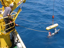
The autonomous underwater vehicle (AUV) SeaBED is deployed over the research vessel Aegaeo's port side! SeaBED is equipped with a high resolution multibeam sonar system that can provide centimeter-scale information about the sea floor. This technology allows researchers to map the sea floor quickly, and to document the distribution and physical characteristics of shipwrecks and geologic features. Click image for larger view and image credit.
Using Multibeam Systems for Mapping
July 2, 2006
37 N, 25 E
Vicki Verrini
Research Associate
Woods Hole Oceanographic Institution
I am interested in using sonar systems to study the physical processes that shape the sea floor. During this cruise, I have been fortunate to collaborate with Greek colleagues who have similar technical and research interests, and have helped with multibeam sonar mapping efforts conducted with the research vessel (R/V) Aegaeo’s hull-mounted system. Together we have documented very interesting sea-floor features that are related to the geologic and volcanic setting of the areas we have visited.
Multibeam sonar systems not only provide information about the depth and shape of the sea floor, they can also be used to identify and describe shipwrecks. The autonomous underwater vehicle (AUV) SeaBED is equipped with a high resolution multibeam sonar system that can provide centimeter-scale information about the sea floor. This technology allows us to map the sea floor quickly, and to document the distribution and physical characteristics of shipwrecks.
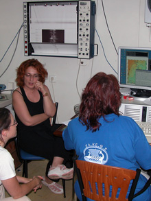
Hellenic Center for Marine Research multibeam specialist Martina Alexandri processes data collected from the R/V Aegaeo's multibeam system. During Project PHAEDRA 2006, researchers will use two different multibeam systems to acquire sea-floor data at different resolutions. Click image for larger view and image credit.
Precise vehicle navigation is critical to a successful multibeam sonar survey. This is straightforward with a ship that uses satellite-based DGPS (Differential Global Positioning System), but it is more complex with underwater vehicles which rely upon acoustic navigation. The AUV SeaBED is equipped with a high-precision navigational system that will ensure high quality data. In addition to navigation, it is important that we monitor the motion of the survey platform to ensure that the data are properly positioned on the sea floor.
High resolution multibeam sonar data provide valuable information to a variety of scientists and archaeologists. By using sonar systems to map the sea floor, we can effectively see its shape as we would if the water were removed. New computer visualization techniques allow us to display and navigate through the three-dimensional representations of these datasets, and to overlay bottom photographs, photomosaics, and sample locations. In this way, we gain a more complete understanding of the complex sea floor.Sign up for the Ocean Explorer E-mail Update List.